4.5, 4.11 - Maps and scale drawings
A map or plan shrinks real lengths by one consistent scale. Use construction skills from 4.5 to make accurate plans, and the map skills in 4.11 to convert distances and compare routes. You will work with ratio scales, scale bars and labelled lengths.
Scale and common units
A map route measures at scale . Is that a short walk or a long journey? The scale turns a paper measurement into a real distance, but the units must agree first.
You already know
A ratio compares quantities in the same unit. Use and . Measure paper lengths carefully with a ruler.
At this scale, one centimetre represents . A map centimetre does not represent metres.
Ratio scale
A scale means one unit on the drawing represents of the same unit in reality. The ratio compares lengths. For example, means represents .
Multiplication enlarges a drawing length to its real length. Division shrinks a real length to fit the drawing. The unit stays the same during that multiplication or division; convert afterwards if helpful.
Scale conversion
For lengths in the same unit,
These are linear lengths, not areas. Not in the formulae sheet at either tier: learn it.
Start with the opening map measurement and keep track of the unit at each line.
Worked example 1: map to reality
Question. Find the real distance in kilometres represented by at .
Plan. Multiply to find real centimetres, then convert to kilometres.
Why multiply? The real route is times the drawing length.
Answer. .
Check. Each map centimetre means , and .
Change only the map measurement. The conversion per centimetre stays fixed.
Worked example 2: a longer map distance
Question. Find the real distance in kilometres represented by at .
Plan. Use the same scale and unit conversion.
Why divide by last? There are that many centimetres in one kilometre.
Answer. .
Check. The extra represents ; .
For planning, the real distance may be known instead. Convert it to centimetres before dividing by the scale denominator.
Worked example 3: reality to map
Question. How many centimetres represent at ?
Plan. Express the real distance in centimetres, then shrink it.
Why divide? We need the small drawing length rather than its much larger real counterpart.
Answer. .
Check. .
Change only the real distance. Use the same denominator and the same unit conversion.
Worked example 4: a different real distance
Question. How many centimetres represent at ?
Plan. Convert, then divide.
Why use centimetres? The requested map length is in centimetres, so the real length must use the same unit before division.
Answer. .
Check. .
A smaller denominator gives a larger drawing of the same object: shows it larger than . Use this direction check when choosing whether to multiply or divide.
Watch out
Wrong: gives the map length in centimetres for . The units do not match. Correct: .
Keep the scale fixed and change the real distance again.
Routes and scale bars
A route follows its actual path; a straight line joins only the endpoints. Those lengths can differ even when both measurements are accurate.
Scale bar
A drawn segment labelled with the real distance it represents. Compare a map length with the bar using the same ruler or the same grid intervals.
A scale bar has a useful advantage: if a map and its bar are enlarged together, they still give the correct real distance. Both measured lengths multiply by the same factor, so their ratio is unchanged. For example, . A printed ratio such as assumes the intended printing size; doubling that size changes the physical scale to .
[DIAGRAM: asset_slug: m064_map_routes; caption: The route A–B–C is seven intervals and the shortcut A–C is five; description: AB is four grid intervals and BC is three; the scale bar spans two intervals and represents 500 m; screen centimetres are not a physical map scale; file: map_routes.png; recommended_method: matplotlib]
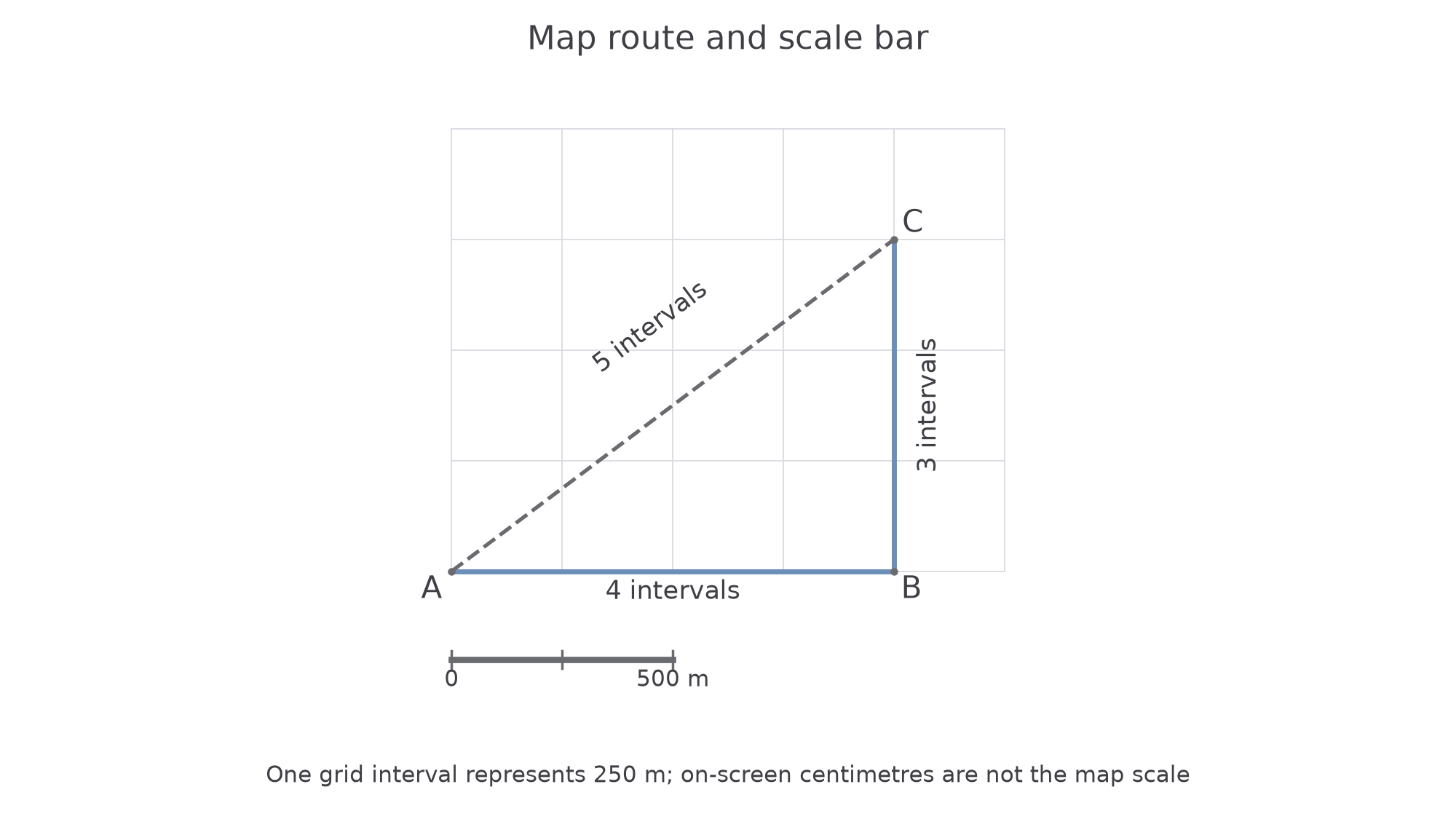
Count the labelled intervals here. Do not put a ruler against the screen and treat screen centimetres as map centimetres.
Worked example 5: route and shortcut
Question. On the map, is four intervals, is three and the supplied straight distance is five. Each interval represents . How much distance does the shortcut save?
Plan. Add the route pieces, convert both paths and subtract.
Why add before converting? Every route piece uses the same scale, so their sum can be scaled in one step.
Answer. The shortcut saves .
Check. It removes two intervals: .
Continue this lesson.
You’re previewing NovaLearn without an account. Create a free account to read the rest.
Create free account