3.3.2, 3.3.4.2 - Fieldwork design, sampling and method justification
Learn how 3.3.2 connects a geographical question to feasible evidence, and how 3.3.4.2 values justified field methods. Use the original fictional designs to practise method decisions without developing a plan for an assessed investigation.
From the question to a feasible method
A method is useful when it produces evidence that can address the geographical question under the actual field conditions.
Start with the concept or process, identify an observable indicator, and decide how to measure or record it. An indicator is an observable measure used to represent a broader characteristic. A pedestrian count indicates movement during a stated window; it does not directly measure residents' satisfaction. An environmental quality score records the features in its scoring criteria; it does not automatically measure an entire community's quality of life.
In an original fictional methods exercise, trainees compare infiltration across surface-cover types. They would need infiltration readings with consistent units and a record of cover, soil conditions and location. Repeating the same procedure matters: changing both the cover and the measurement duration makes the results difficult to compare. A human-geography exercise about experiences of place might need open questions or interviews, because a traffic count cannot reveal what a place means to someone.
Justification explains why a method fits the evidence need. “It is easy” identifies convenience, not geographical suitability. A better reason connects method and question: an interview allows participants to explain contrasting experiences that a fixed numerical score may conceal. It also recognises feasibility: safe access, permissions, equipment, time and ethical participation constrain what can be collected.
A pilot is a small trial used to check that the method can produce the required evidence. It can expose an unclear questionnaire question, an unusable recording category or an unsafe site. Modify the method before the main collection and record the reason. Generic tuition can teach this decision; the candidate must make the relevant choices for their independent enquiry.
Sampling space and time
Sampling makes a large population manageable, but the selection method affects which places, people or times the findings represent.
The population is the full set relevant to the question; the sampling frame identifies the units available for selection. A unit might be a soil point, street segment or person. Define it before deciding how many to select.
| Strategy | Selection rule | Geographical use and limitation |
|---|---|---|
| Simple random | Select by a genuine random process from a defined frame | Reduces deliberate selection bias; a small sample can still miss a part of the area by chance. |
| Systematic | Use a fixed interval in an ordered frame, with the start specified | Useful for consistent coverage along a gradient; periodic patterns can coincide with the interval and bias results. |
| Stratified | Divide the population into relevant groups, then sample within each | Ensures those groups are represented; strata and their proportions must fit the question. |
| Opportunistic | Use available or conveniently accessible units | Practical but may overrepresent easy-to-access sites or willing participants; it is not random merely because no named people were chosen in advance. |
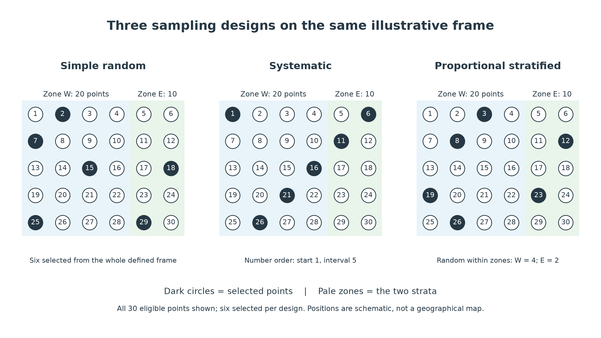
Original illustrative site frame: 30 numbered candidate points, with 20 in Zone W and 10 in Zone E. Each panel selects six points. The stratified example allocates four to W and two to E to reflect those proportions; points are selected randomly within each zone. The systematic example takes every fifth numbered point from a stated start. These are controlled training coordinates, not a real map or observed fieldwork.
Representativeness also has a temporal dimension. A lunchtime pedestrian sample may describe lunchtime well but miss commuting or evening activity. A beach measurement after a storm may differ from one in calm conditions. Select frequency and timing to address the question and record conditions. Repeated times and spatially distributed sites can improve coverage, but more readings do not repair a biased frame. There is no universal number of sites, questionnaires or methods that guarantees quality.
Continue this lesson.
You’re previewing NovaLearn without an account. Create a free account to read the rest.
Create free account