3.1.5.5 - Tropical storms and hazard patterns
Tropical storms draw energy and moisture from warm oceans, but their hazards can extend far inland. This lesson connects formation to wind, coastal and catchment processes, then shows how distribution, frequency and forecasts should be interpreted.
Formation and ocean energy
A tropical cyclone is an organised low-pressure system with rotating winds and deep convection, sustained by heat and moisture from the ocean.
Warm surface water, commonly around 27°C or above, encourages evaporation. Rising moist air cools and condenses; latent heat released during condensation helps maintain buoyant rising air and low surface pressure. More air converges towards the low pressure, supplying moisture. Sufficient Coriolis deflection helps organise rotation, while weak vertical wind shear allows the circulation and convection to remain aligned. A pre-existing disturbance and moist, unstable air also matter. Warm water alone does not guarantee formation. NOAA's formation explanation describes these interacting conditions.
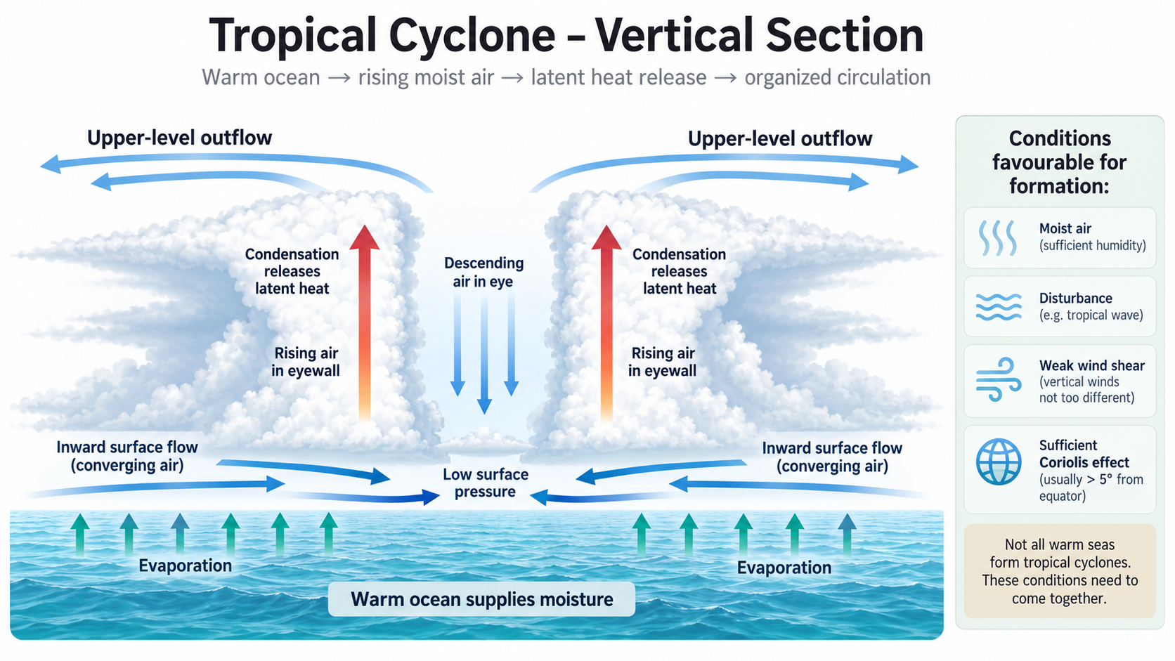
The vertical section is conceptual. Its arrows show airflow and moisture transfer rather than a measured wind field.
The eyewall contains deep rising cloud and often the strongest winds; mature storms may have a relatively calm eye with descending air. High-level outflow removes air from the top of the system. Condensation releases energy previously absorbed during evaporation; a cyclone does not create energy from nothing. Over cooler water or land, reduced ocean heat/moisture supply and greater friction can weaken the circulation. Heavy rain can continue even as maximum wind speeds decrease.
“Hurricane”, “typhoon” and “cyclone” refer to the same broad phenomenon in different regions. Basin terminology and wind averaging conventions should be checked before numerical comparisons. In the North Atlantic, a tropical cyclone with maximum sustained winds at least 64 knots is called a hurricane; this threshold is a wind classification, not a flood-risk boundary.
Wind, storm surge and coastal flooding
Wind and elevated coastal water levels produce distinct hazards that can interact at an exposed coast.
Strong winds load roofs and walls, break trees and power lines, and carry debris. Failure depends on gusts, duration, building strength and shelter, so the maximum storm wind is not a uniform wind speed across the affected region. Broken electricity infrastructure can then interrupt health care, communications and water pumping: direct damage produces secondary disruption.
Storm surge is the abnormal rise of sea level above the expected astronomical tide caused by the storm, mainly through wind-driven water accumulation and also low pressure. Onshore winds, a broad shallow continental shelf and a funnel-shaped coast can increase surge. Its timing relative to tide affects the actual water level. Storm tide combines surge with the astronomical tide; waves may produce additional run-up and overtopping.
Coastal flooding occurs when water inundates land. Surge is one driver, but waves, tide and local rainfall/drainage can contribute. Salt water damages crops and electrical systems and can contaminate freshwater supplies. An intact raised building may still be isolated by flooded roads. A wind-only category therefore cannot summarise inundation depth, spatial extent or all consequences.
Continue this lesson.
You’re previewing NovaLearn without an account. Create a free account to read the rest.
Create free account