3.1.6.6, 3.1.6.7 - A local ecosystem and conservation
Use Wicken Fen as a complete worked local ecosystem for a Cambridge-area reference centre, interpret conservation evidence, and adapt the enquiry to an accessible ecosystem near your own home or study centre.
Wicken Fen's ecological setting and water controls
Wicken Fen National Nature Reserve lies in Cambridgeshire, northeast of Cambridge. Its historic fen, adjacent former agricultural fields and wider Wicken Fen Vision landscape have different boundaries and histories. Wetland, ditches, reedbeds, open vegetation and scrub provide contrasting habitats. This provider-selected worked example uses a Cambridge-area reference setting; it is not a claim that Wicken is local to every learner.
The temperate lowland climate has seasonal temperature and evaporative-demand changes: summer water loss can draw down stores, while cooler-season conditions generally reduce demand. Fen vegetation depends on rainfall and the surrounding hydrological system, alongside evapotranspiration and drainage. Annual rainfall alone cannot determine wetness. The grazing study uses weather records from NIAB Cambridge, 16 km southwest, so that station is a nearby climatic reference rather than a measurement inside every fen patch.
Peat forms where organic accumulation exceeds decomposition; prolonged low-oxygen wet conditions slow decay. Lowering the water table exposes peat to oxygen, increasing decomposition and possible subsidence. The study reports remaining peat depths of 0.7–0.9 m at Adventurers Fen, 0.3–0.4 m at Bakers Fen and 0.15–0.25 m at Guinea Hall. These are study-site descriptions, not current measurements of the whole reserve. Past cultivation, underlying mineral material and ditch position help explain variation in soils and moisture.
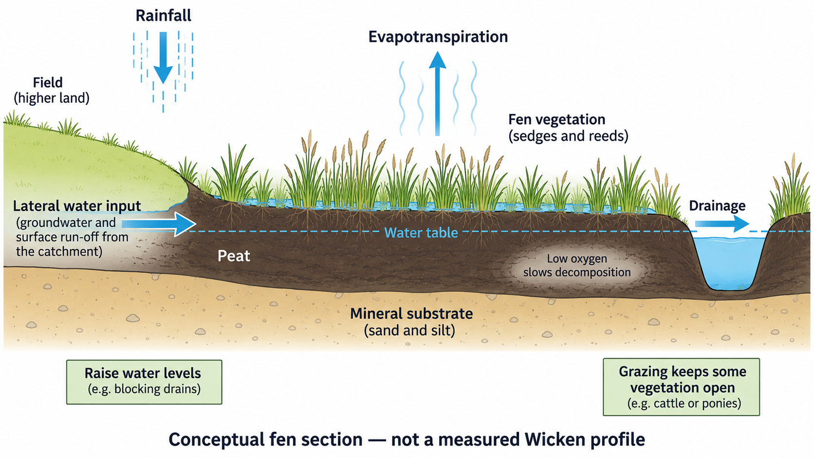
This section illustrates processes rather than measured Wicken elevations or groundwater gradients. Water-level management and grazing address different ecological controls.
Wetland plants such as reeds can transport air into submerged tissues, while sedges vary in their tolerance of water levels and nutrient conditions. More freely drained former fields support different communities from persistently wet areas. Wet habitats support invertebrates and their predators; dragonfly larvae use aquatic habitats before adults emerge, linking water conditions and terrestrial feeding spaces. Birds use vegetation structure for shelter, nesting and feeding. These mechanisms explain why changing soil moisture or canopy structure can alter fauna as well as plants.
Agriculture, urban connections and introduced species
Agricultural drainage and cultivation changed parts of the fen landscape into fields. Drainage can lower water tables, alter peat and replace wetland communities; nutrient inputs can favour productive competitive plants. The restoration study's former arable fields retain different peat depths and land-use histories, so they do not all start from identical ecological conditions. Rewetting must account for drainage connections and neighbouring land management.
Wicken Fen Vision seeks a connected landscape towards the Cambridge edge. Urban growth can increase demand for recreation, transport and water, while access can support conservation awareness and revenue. Trampling, disturbance, waste or altered drainage are plausible pressure pathways requiring local measurement; a future landscape vision does not prove that each has already caused a quantified loss at Wicken. Paths, sensitive-area access and engagement can manage use while retaining public benefits.
Planned introduction of Highland cattle and Konik horses provides extensive grazing on recovering land. Grazing changes height, litter, scrub establishment and habitat structure; trampling or browsing can also be damaging at unsuitable intensity. Introduction is a management tool, not an automatic biodiversity gain. The study reports introduction during 2003–2005, with later connections among fields; its historical stocking arrangements must not be presented as current policy.
Muntjac occur at Wicken, as the National Trust's trail account records. Their unplanned spread is distinct from deliberate livestock introduction. Browsing can affect seedlings and understorey vegetation, but occurrence alone does not quantify damage or prove a local control programme. To investigate impact, compare recruitment and browsing inside and outside suitable exclosures, accounting for other grazers and environmental differences. Planned and unplanned introductions should be evaluated through their actual effects, not assumed good or bad from the label.
What Wicken's paired grazing evidence shows
Stroh and colleagues' 2021 study used seven 25 m by 25 m grazing exclosures within a 119-hectare former-arable study unit containing Adventurers Fen, Bakers Fen and Guinea Hall. At each exclosure, two quadrats inside and two outside gave 28 quadrats per sampled year. Outside quadrats were 5 m from the edge, and pairs were equidistant from ditches. The fences excluded cattle, horses and deer, but did not remove all small animals.
Sampling in mid-June during nine years from 2007 to 2017 allowed repeated comparisons; 2015 and 2016 were not sampled. The wettest standing-water areas were avoided. Consequently, the evidence concerns these sampled vegetation conditions and cannot be generalised automatically to the whole reserve or all seasons.
Grazed quadrats had higher species richness; annual mean richness declined in ungrazed quadrats. Ungrazed vegetation developed greater canopy height and litter. A plausible mechanism is that reduced grazing permits taller competitors and accumulated litter to limit light or establishment for shorter plants. Land-use history and field differences also mattered. Pairing improves comparability near the same ditch, but does not make all other controls identical or isolate livestock from deer effects.
Distinguish annual richness from cumulative richness. Annual richness counts species in that year's sample; cumulative richness adds all species recorded across the period and can rise even when the annual count falls. The study supports a particular grazing effect during restoration; it does not prove that more grazing is always better or that the reserve's entire biodiversity increased.
Continue this lesson.
You’re previewing NovaLearn without an account. Create a free account to read the rest.
Create free account