3.2.1.5, 3.2.1.5.1 - Global commons and Antarctic geography
Explain why global commons provide widely shared benefits, and why access must be considered alongside protection. Locate Antarctica and its surrounding ocean, distinguish physical from legal boundaries, and connect its climate and ecosystems with vulnerability.
Global commons and shared benefits
Some environments provide benefits extending across borders and beyond the exclusive control of one state.
Global commons
Areas or systems with shared international significance that extend beyond exclusive national control, whose benefits and protection require cooperation. Different commons have different legal arrangements.
The high seas, atmosphere and outer space illustrate shared systems; the Antarctic region is studied as a global common because its peace, science and environmental functions concern humanity widely. This does not mean each has identical ownership rules, or that Antarctica is legally owned by the UN. The Antarctic Treaty preserves parties' positions on territorial claims rather than abolishing them. Antarctic Treaty, Article IV.
Universal rights to benefits expresses the principle that people everywhere should share in benefits such as knowledge, environmental security and conserved biodiversity. A person need not visit Antarctica to benefit from climate research. Universal benefit does not mean an unrestricted legal right for each person to extract resources or damage habitats. Rules can protect the common and distribute access fairly.
Sustainable development meets present needs while protecting future capacity. A state may seek economic opportunities or scientific access; protection may limit how it pursues them. Wealthy states can more easily fund research and travel, so formal openness does not guarantee equal practical access. Ask whether decisions protect long-term benefits and whose interests and costs they include, rather than assuming immediate exploitation is the only form of development.
Locating Antarctica and its regions
Antarctica is an ice-covered continent centred on the South Pole, surrounded by ocean rather than sharing a land border with another continent.
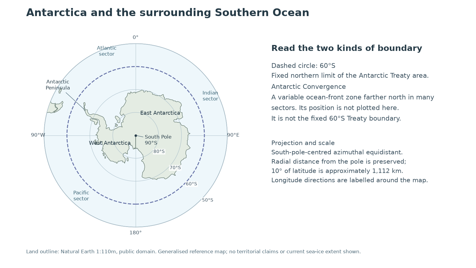
The Antarctic Peninsula extends towards southern South America; East and West Antarctica are broad continental regions. The land outline is generalised Natural Earth geographical data, not a map of current sea ice or territorial claims. Read longitude directions around the pole: moving towards the map edge means moving north from 90°S. The projection preserves radial distance from the pole, not all distances between arbitrary points.
An ice sheet is a large body of land ice. An ice shelf is floating ice attached to land ice at the coast. Sea ice forms by freezing seawater and expands and contracts seasonally. These coverages must not be combined as though they were one permanent land boundary. BAS identifies the larger East Antarctic ice sheet and a more vulnerable West Antarctic setting where much underlying land lies below sea level. BAS, Antarctic geography overview.
The Treaty applies south of 60°S, including ice shelves, while preserving high-seas rights under international law. This fixed legal line differs from the continent's irregular outline and the ocean's shifting physical fronts. A latitude is a location reference; it does not describe the same climate at every longitude. Antarctic Treaty, Article VI.
The causes and contrasts of Antarctic climate
Antarctica's climate is severe, but conditions vary between the elevated interior, coast and Peninsula.
High latitude gives a low solar angle, spreading incoming energy over a larger surface; the long winter brings prolonged darkness. Snow and ice have high albedo, reflecting much incoming sunlight. The elevated interior is additionally cold because temperature generally decreases with altitude. These mechanisms reinforce one another rather than explaining cold solely through distance from the equator.
The Australian Antarctic Program gives an approximate annual-temperature range from −10°C at the coast to −60°C in the highest interior. It reports annual snow accumulation equivalent to less than 50 mm of water over the elevated plateau, compared with generally more than 200 mm near the coast. These are broad reference contrasts, not a station-by-station dataset or one year's observations. Australian Antarctic Program, Antarctic weather.
Cold air holds little water vapour, and subsiding air over the interior limits cloud formation. The interior is therefore a polar desert despite its accumulated ice. Coastal air has greater moisture availability and stronger influence from oceanic low-pressure systems. A large store of ice reflects long-term accumulation, not necessarily high present precipitation.
Katabatic winds form when very cold, dense air flows downslope from the elevated ice sheet. Gravity accelerates this flow; valleys can concentrate it. Winds can disrupt travel and disperse snow, affecting both human operations and measurements. A coastal storm and a katabatic flow may interact, so severe conditions have multiple causes.
The Southern Ocean and Antarctic Convergence
The Antarctic environment includes surrounding Southern Ocean waters northwards to the Antarctic Convergence, as well as continental land and ice.
The Southern Ocean connects the Atlantic, Indian and Pacific ocean basins. The Antarctic Circumpolar Current flows predominantly west to east around the continent. The Antarctic Convergence, or Polar Front, is a zone where colder Antarctic waters meet warmer waters farther north; its location varies with longitude and time. It is a physical transition, not the Treaty area's fixed 60°S line. Australian Antarctic Program, Antarctic geography.
Mixing and the supply of nutrients help support marine productivity. Phytoplankton form the base of many food relationships; krill transfer energy to predators including penguins, seals and whales. Species and physical processes connect places beyond a line on a map. Protecting only land would leave the marine feeding areas and connections outside that focus.
CCAMLR's marine-living-resource Convention Area uses specified coordinates which approximate this wider ecological region and extend north of 60°S in several sectors. Its legal boundary is defined precisely for administration, while the real ocean front is variable. Do not use the CCAMLR boundary as a measured current position of the Convergence. CCAMLR Convention Area.
Boundaries therefore answer different questions: the continent identifies land; seasonal sea-ice extent identifies a changing surface cover; the Convergence identifies an ocean transition; Treaty and CCAMLR boundaries identify legal coverage. A supported spatial comparison states which one is being used.
Shared value and vulnerability
Antarctica's global value and local vulnerability arise from the same distinctive physical and ecological conditions.
Its ice stores records of past climate, and research can improve understanding of changes affecting people elsewhere. Changes in land-ice mass affect global sea level; loss of sea ice has different direct sea-level implications because it already floats. The Southern Ocean participates in global heat and carbon exchanges, while Antarctic food webs sustain biodiversity beyond individual national interests. BAS, Antarctica and climate change briefing.
Cold conditions and short growing seasons can slow recovery from disturbance. Wildlife and human activity concentrate at accessible ice-free or coastal sites rather than spreading uniformly over the continent. Small affected areas can therefore contain important breeding habitat. Remoteness makes monitoring, rescue and clean-up difficult, while global emissions can alter conditions even where local disturbance is tightly regulated.
Economic pressures include demand for marine resources and tourism; research also needs transport, buildings, fuel and waste management. Their footprints vary by location, season and practice. A small visitor count at a sensitive breeding site may matter more than a larger number kept away from wildlife. Assess pressure against ecological sensitivity and cumulative effects, not just a continent-wide total.
The tension is between different ways of sharing present and future benefits. Research access can generate public knowledge while causing local impacts; tourism can bring experience and commercial income while disturbing habitats. Effective protection can preserve future benefits but carries immediate costs for operators or states. A judgement should identify the activity, scale, evidence and feasible conditions under which benefit and protection can coexist.