3.1.1.2, 3.1.1.5 - Drainage basins and water balance
Under 3.1.1.2, follow water through a drainage basin's stores and pathways, from rainfall to evaporation or river outflow. Under 3.1.1.5, use mass balance and unit conversion to calculate changes in water and carbon stores without counting internal transfers twice.
Basin boundaries and fluxes
A drainage basin connects the land draining towards a river and its tributaries to a chosen outlet.
Drainage basin and watershed
A drainage basin, or catchment, is the area contributing drainage to a specified river outlet. A watershed is the topographic divide separating neighbouring basins, commonly following higher ground.
Rain or snow is a precipitation input when it crosses from the atmosphere into the basin. Its amount, duration and distribution affect how much water is available. The rain measured at one gauge may not represent an entire basin: upland and lowland areas can receive different amounts. For a basin calculation, use the supplied basin-average precipitation rather than silently treating a point observation as an area average.
Evapotranspiration combines evaporation from water, wet vegetation and soil with transpiration, the release of water vapour by plants after roots take up water. It is a basin output to the atmosphere. Available energy, humidity, wind, vegetation and water availability affect the total. Runoff is water leaving towards the drainage network and, for the whole-basin budget used here, river water crossing the chosen outlet. It includes water that reached the river over the surface or through the ground; it is not synonymous with overland flow alone.
The basin is an open system because water and energy cross its boundary. A surface watershed does not always coincide with a groundwater divide: water can cross through connected rocks. Abstraction, piped imports and groundwater exchanges would be additional budget terms where significant. Our simple budgets state explicitly when these are absent, rather than claiming every real basin has only rainfall, evapotranspiration and river runoff.
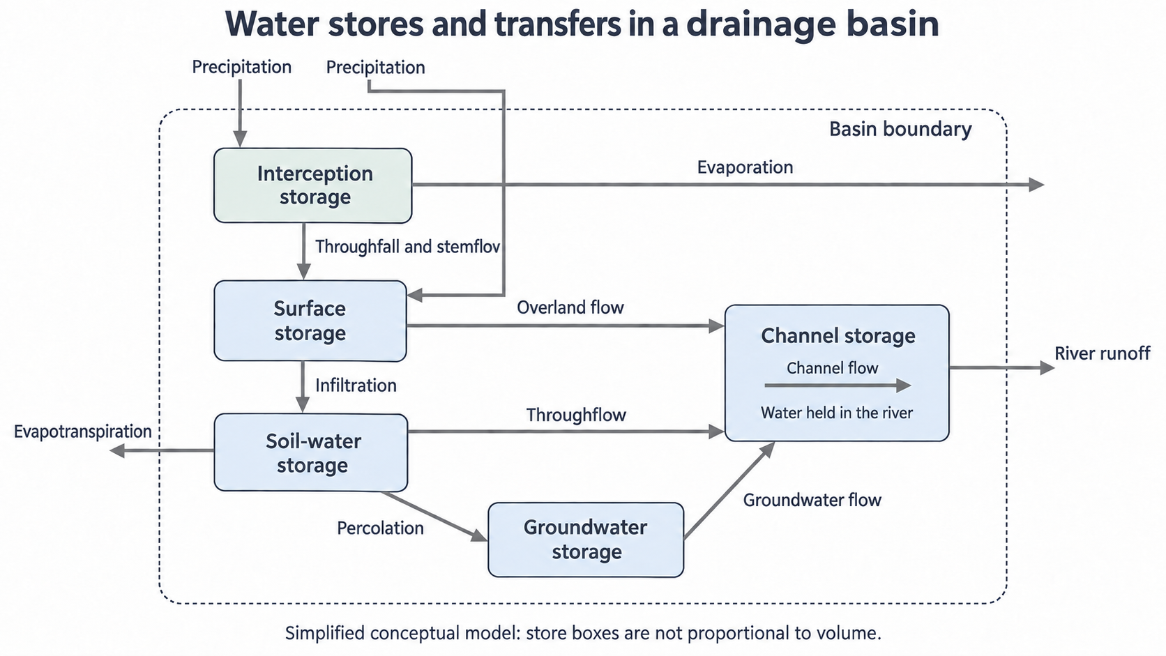
Simplified conceptual basin model. Boxes are not proportional to volume; only selected evaporation pathways are shown. Water can enter the surface directly or pass through vegetation. Channel flow is internal until it crosses the chosen basin outlet.
Read the schematic by identifying a store before tracing the arrow that fills or empties it. The top-to-bottom arrangement helps show connected pathways; it is not a map or a claim that every catchment has the same geology.
Canopy and surface stores
Some precipitation is temporarily held above or on the ground before entering the soil or a river.
Interception storage is water retained on vegetation, such as leaves, branches and stems. Initially, a dry canopy can hold some incoming rain. As it becomes wetter and its storage capacity is approached, more water reaches the ground. A canopy's effect therefore depends on leaf area, season and storm duration, not simply whether a tree is present.
Water can evaporate from the canopy, becoming an atmospheric output. Throughfall is precipitation reaching the ground through gaps or dripping from foliage. Stemflow runs down branches and stems towards the ground, concentrating delivery near the plant base. Both are internal transfers once the rainfall has entered the basin. Counting rainfall and then adding stemflow as a second basin input would count some of the same water twice.
Surface storage includes water held in puddles, depressions, lakes and wetlands. This can delay onward movement, allow infiltration or provide a surface for evaporation. If a depression fills and spills, water can continue downslope. Storage is the quantity held; water flowing across that surface is a transfer. An open water surface can therefore both store water and pass water onwards.
For example, during an original illustrative shower over woodland, the canopy holds part of the rain. Some evaporates; some drips or runs down stems into small ground depressions. Water reaching these depressions can infiltrate or spill towards a channel. The sequence explains a delay without implying that interception permanently removes all rain or that woodland always prevents runoff.
Soil and groundwater pathways
Water below the surface can be stored or transferred, depending on pore space, permeability and gradients.
Infiltration is entry of water from the surface into soil. Infiltration capacity is the maximum rate at which a surface can take in water under the current conditions. Open connected pores and cracks can allow entry; compaction or surface sealing can reduce it. Water that infiltrates adds to soil-water storage, occupying spaces in the soil where it can be taken up by roots, evaporated or moved onwards. Unsaturated soil contains both air and water in its pores; saturated material has its connected pore spaces filled with water.
Percolation is downward movement through soil and permeable material, which can recharge groundwater. Groundwater storage is water held in the saturated zone. An aquifer is a body of rock or sediment that can store and transmit useful amounts of groundwater; the water table is the upper surface of the saturated zone in an unconfined aquifer. Groundwater is held in pores and fractures, not necessarily an underground cavern.
Throughflow is lateral water movement within the soil towards a channel, while groundwater flow occurs through the saturated material. Both can support river flow after rain has ended. A deeper or less permeable pathway often delays delivery compared with surface movement, but the actual time depends on permeability, gradient and distance. Fractured rock can allow relatively rapid movement; no universal speed follows from the label groundwater.
Trace a drop that infiltrates a hillside. It may remain in the soil, travel sideways as throughflow, or percolate into groundwater and later emerge into a stream. These are alternatives, not a compulsory sequence for every drop. Infiltration also does not guarantee permanent storage: it changes the route and may delay water arriving at a channel.
Infiltration is entry through the surface; percolation and lateral flows move water after entry. Soil water and groundwater name stores, not movement rates.
Surface and channel routing
Water reaches channels by several routes, and channel storage must be distinguished from channel flow.
Overland flow moves across the ground surface. It can develop when rainfall intensity exceeds infiltration capacity, even if deeper soil is not saturated. It can also occur when soil is saturated and cannot accept additional water, or where groundwater returns to the surface. A paved surface may greatly restrict infiltration, while a saturated hollow may generate overland flow even in a basin with permeable soil elsewhere. These mechanisms explain why surface runoff cannot be predicted from slope alone. USGS's infiltration account explains the storage and pathway controls.
Channel storage is the water held in the river channel at a given time. Channel flow transfers that water along the channel. Water reaching a channel by overland flow, throughflow or groundwater flow can increase its storage unless outgoing flow rises by the same amount. Internal channel movement becomes a whole-basin output only at the defined outlet.
Consider two original illustrative hillslopes receiving the same rain. One has dry, well-structured soil; much water can infiltrate, with some stored and some taking subsurface routes. The other has a sealed surface; more rain can travel overland and reach a nearby channel quickly. This comparison suggests a different pathway mix. It does not alone determine a flood peak: basin size, distance to the outlet, channel conditions and rainfall distribution also matter. Flood hydrographs are developed in the next lesson.
When interpreting route data, identify the categories and denominator. If a table states percentages of water reaching a river, it describes the mixture of channel inflows, not percentages of all rainfall. Compare the largest and smallest routes, changes between settings and any supported contrasts. Do not add the same water's infiltration, percolation and final groundwater discharge as separate amounts of basin output: one parcel can undergo all three.
Water and carbon mass balance
A mass balance accounts for the difference between inputs and outputs as a change in storage.
For the simplified basin used here:
is precipitation, is evapotranspiration, is river runoff at the outlet, and is storage change over the same period. This form assumes no other material boundary exchanges.
A positive means stores increase overall; a negative value means water is released from storage. It is a change, not the amount already stored. In an original illustrative annual basin budget, , and millimetres, all expressed as basin-average equivalent depths. Thus . If starting storage is equivalent to 180 millimetres, ending storage is 240 millimetres. Internal transfers such as infiltration do not enter as extra basin losses; they redistribute water among stores already included in .
The annual total can conceal seasonal change. During wetter, lower-evaporation periods, precipitation may refill soil and groundwater stores; additional water can then support runoff. In drier periods, evapotranspiration and runoff can exceed current precipitation by drawing on earlier storage. A seasonal water deficit is not evidence that the budget violates conservation. Actual evapotranspiration eventually becomes constrained if accessible soil water is depleted, so it cannot be assumed to rise without limit as temperature increases.
Depth budgets compare water over a common area. To convert a depth into a volume, convert both depth and area before multiplying:
Here is equivalent water depth, is basin area and is volume.
The illustrative 60-millimetre storage gain over a 2-square-kilometre basin equals . A useful check is that 1 millimetre over 1 square kilometre equals 1000 cubic metres. Never multiply millimetres directly by square kilometres and label the result cubic metres.
The same conservation principle applies to carbon, using carbon mass consistently. For an original illustrative vegetation-only system, annual photosynthesis brings in 24 megagrams of carbon; plant respiration releases 10 and litter transfer removes 7 into soil outside this chosen vegetation boundary. Net vegetation storage change is of carbon. Since , this is 7000 kilograms of carbon. If the boundary included both vegetation and soil, litter transfer would be internal and would no longer be subtracted as a system output. Carbon mass must not be mixed with carbon-dioxide mass: they are different measures.
When a real budget does not close exactly, check the period, units, measurement uncertainty and omitted fluxes before claiming that material was created or destroyed. Rainfall sampling error or an unmeasured groundwater exchange can affect the residual. A simple budget is a stated model with assumptions, not a perfect measurement of every catchment.