3.5 3.a, 3.b - Earthquake characteristics, landscapes and hazards
Earthquakes release energy when faulted rocks slip, but their effects depend on more than event size. This lesson explains depth and measurement, fault-generated landscapes and the mechanisms linking shaking to liquefaction, slope failure, tsunami and flooding.
Shallow and deep-focus earthquakes
An earthquake begins when a fault slips and stored elastic strain energy is released. The focus, or hypocentre, is the point where rupture starts below ground; the epicentre is the point vertically above it at the surface. Rupture then spreads over a fault area, so a large event is not physically confined to a single point.
Seismic waves carry energy away. P waves involve compression and can travel through solids and liquids. S waves involve shear and do not propagate through a liquid outer core. Surface waves and other wave interactions can contribute strongly to damaging motion. Arrival times help locate an event, but the earliest instrument detection is not prediction before rupture.
A common three-part classification is shallow focus, less than about 70 kilometres; intermediate, about 70–300 kilometres; and deep, about 300–700 kilometres. Some older accounts use “deep-focus” more broadly for all events below 70 kilometres, so specify the convention. The USGS depth explanation provides both usages.
Divergent and transform settings usually produce shallow events, while subduction produces an inclined distribution extending to intermediate and deep focus within descending lithosphere. The relatively cool slab can sustain earthquake-generating processes deep into the mantle, where surrounding hot rock generally deforms more continuously. Continental collision generates extensive faulting, often at shallow or intermediate depths, rather than a uniform deep subduction pattern everywhere.
Other conditions equal, a shallow source is closer to nearby surface sites and can produce severe local shaking; a deep event's waves travel farther before reaching the surface. However, magnitude, rupture direction, duration, geology and distance also matter. “Shallow” does not automatically mean greater damage than every deeper event, nor does an epicentre alone show the full affected area.
Measuring magnitude and intensity
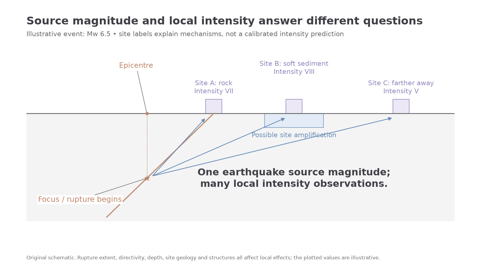
Magnitude describes the size of an earthquake source, while intensity describes effects at a particular location. An event can have one preferred magnitude estimate and many different local intensities. Instrumental estimates can be revised as data improve; that is not evidence that the earthquake became larger after it ended.
The original Richter local magnitude uses a logarithm of measured seismic-wave amplitude corrected for distance, developed for a particular regional instrument system. It remains useful in suitable local applications but saturates for large events: its particular amplitude measure does not continue to reflect total rupture size adequately. It is inaccurate to label every modern reported magnitude “Richter”.
Moment magnitude, written , is based on seismic moment, related to rock rigidity, fault area and average slip. It better represents very large ruptures and supports comparison across event sizes. Neither scale is a percentage or a direct death-toll index. The USGS magnitude explanation connects source size and shaking.
For relevant amplitude-based comparisons, one magnitude unit corresponds to a factor of ten in corrected amplitude, not ten times the energy. A widely used approximate energy comparison is ; a one-unit difference corresponds to about 32 times and two units to about 1,000 times. This is an approximation, not an exact statement about every building's motion. USGS's measurement discussion distinguishes these quantities.
Worked example 1: a one-unit difference
Illustrative comparison: events have magnitudes 5.2 and 6.2.
The larger event releases approximately 32 times as much energy. The corresponding corrected amplitude ratio in a suitable amplitude-based comparison is , a different quantity.
Worked example 2: a two-unit difference
Two other events have magnitudes 4.7 and 6.7.
The energy ratio is about 1,000, while the corrected amplitude ratio is . Neither ratio predicts deaths or damage at a particular town.
The modified Mercalli intensity scale uses reported and observed effects, commonly from I, not felt, to XII, extreme destruction. It is ordinal rather than an equal-interval energy scale. Distance, depth, local sediment, construction and observer coverage affect the pattern. Mercalli describes local effects rather than source magnitude.
[DIAGRAM: asset_name: One earthquake and different intensities; asset_slug: d37-magnitude-intensity; caption: An illustrative event has one source magnitude but differing local shaking and observed effects; description: A simplified fault source below a surface is connected to three sites at different distances and on different ground. The event magnitude is a single illustrative Mw6.5, while site intensity labels differ and a sediment site shows potential amplification. The diagram is explanatory rather than a calibrated distance–intensity prediction.]
Faulting, escarpments and rift valleys
Fault movement can permanently change landscape position as well as temporarily shake it. A fault is a fracture or fracture zone with relative movement of rock. Movement can be vertical, lateral or oblique; it does not require a wide open gap. Repeated movements accumulate over time, while erosion and deposition reshape their expression.
Continue this lesson.
You’re previewing NovaLearn without an account. Create a free account to read the rest.
Create free account