1.1.3 - Dryland systems, aridity and physical controls
Drylands develop where water availability limits landscape processes and vegetation. This lesson explains how their systems transfer energy and sediment, how aridity is measured, and why rainfall, geology, location and relief produce contrasting polar, desert and semi-arid environments.
Dryland system components and flows
A dryland landscape is an open system because energy and material cross its boundary.
A useful boundary might surround one drainage basin, including its mountain slopes, channels and basin floor. Solar radiation supplies energy for heating and evaporation. Rain, snow, wind-blown dust and sediment entering from an upstream river are material inputs. Water may be stored temporarily as snow, groundwater or soil moisture; sediment may accumulate in a slope, fan or dune. Weathering releases particles from rock, while flowing water, wind and gravity transfer them between stores. Evapotranspiration, water flowing out of the basin and dust blown beyond the boundary are outputs.
System store
A quantity of material held within a defined system, such as sand within a dune. A transfer changes its location; an input or output crosses the chosen system boundary.
The same movement can have different labels at different scales. Sand blown from an alluvial fan to a nearby dune is an internal transfer if both lie inside the boundary. It is an output if the boundary encloses only the fan. A basin with no surface river outlet can still lose water by evaporation and sediment by wind, so it is not a closed system.
Flows are intermittent. Years of sediment accumulation on a slope may be followed by a short flood that transfers much of it to a fan. Low average rainfall therefore does not mean that water does little geomorphic work. Equally, abundant wind energy cannot move a surface cemented by salts or protected by stones. The landscape response depends on whether energy, water and erodible material coincide.
Aridity indices and dryland classification
Aridity compares the supply of water with the atmosphere's capacity to remove it.
Annual precipitation alone is insufficient: the same total may meet most plant demand in a cool environment but very little in a hot, sunny one. Potential evapotranspiration, or PET, is the amount of water that could evaporate and be transpired if water were freely available. Actual evapotranspiration can be much lower because dry soils cannot supply that demand.
UNEP aridity index
Here is mean annual precipitation and is mean annual potential evapotranspiration, measured over the same reference period and in the same units. The ratio has no units. A smaller value indicates a greater water deficit.
The UNEP classification used by FAO and the IPCC's 2022 drylands assessment distinguishes the following intervals. Use the stated boundary convention when classifying a value exactly on a threshold.
| Classification | Annual aridity index |
|---|---|
| Hyper-arid | |
| Arid | |
| Semi-arid | |
| Dry sub-humid |
In this classification, drylands have . Calculate the ratio before selecting its interval, using matching units and reference periods.
Worked example — a semi-arid station
Illustrative dataset: a station has mean annual precipitation of 450 millimetres and mean annual PET of 1,500 millimetres.
The ratio lies between 0.20 and 0.50, so the station is semi-arid. Millimetres cancel, leaving a dimensionless index.
Worked example — a hyper-arid station
Illustrative dataset: another station records 70 millimetres of precipitation and 1,750 millimetres of PET over the same climatic reference period.
This is below 0.05 and therefore hyper-arid. Its precipitation meets a much smaller proportion of potential demand. The index compares long-term climatic quantities, rather than one storm with an annual PET total.
[DIAGRAM: asset_name: Aridity index classification; asset_slug: p15-aridity-index; caption: The UNEP aridity index compares precipitation with potential evapotranspiration.; description: A horizontal numerical scale shows hyper-arid below 0.05, arid from 0.05 to below 0.20, semi-arid from 0.20 to below 0.50, and dry sub-humid from 0.50 to below 0.65. An illustrative calculation places precipitation of 150 mm and PET of 1000 mm at AI 0.15 in the arid interval.]
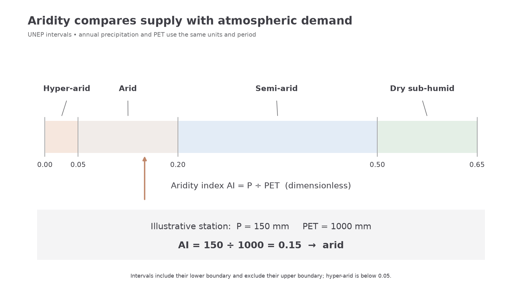
An annual average hides timing. Gentle seasonal rain and one intense storm may give the same annual ratio but very different runoff, infiltration and erosion. Averages conceal drought years, fog inputs and local groundwater access. PET also depends on the estimation method. Treat the index as a comparable climatic indicator, rather than a direct measurement of river discharge or sediment movement.
Climate, geology and location
The balance between water supply and atmospheric demand varies with location, while rock characteristics control how that water changes the surface.
Descending air in subtropical high-pressure belts warms and inhibits cloud formation. This helps explain many low-latitude deserts. Along some western continental margins, cold ocean currents cool the lowest air and encourage stable conditions and fog without producing much rain. Continental interiors receive little maritime moisture, while mountains create rain shadows: air rises and loses moisture on the windward side, then descends and warms on the leeward side. Several controls may operate together.
Latitude influences the angle and seasonality of solar radiation. Higher temperatures can raise PET, but latitude does not determine temperature on its own. High-altitude drylands can experience snow and freezing conditions despite strong daytime sunshine. Mountains also concentrate runoff from wetter headwaters into arid basins. Water moving through a dryland river may therefore have originated far outside the local desert.
Precipitation's frequency matters as well as its total. Long rainless intervals allow loose debris to accumulate. A brief storm whose intensity exceeds infiltration capacity can rapidly connect hillslopes to channels. Permeable sand may instead absorb much of the rain. A hard crust, compacted surface, shallow soil or exposed bedrock can increase runoff; it is incorrect to assume that every desert surface is impermeable. Seasonal rain may sustain vegetation that protects soil between storms.
Lithology means rock type and its properties. Resistant, well-cemented rock can retain steep cliffs; weak rock breaks down more readily. Geological structure includes joints, bedding and faults. Joints admit water, guide weathering and provide blocks for rockfalls. Alternating resistant and weaker beds can create stepped slopes. Faults can establish mountain fronts and basins, increasing relief and the potential energy available to streams. Rock resistance affects erosion, while permeability affects runoff; these are related but distinct properties.
Death Valley demonstrates the importance of event intensity. At Furnace Creek on 20 August 2023, NPS measured 55.88 millimetres of rain during the remnants of Hurricane Hilary. Its account documents flooding, road undercutting and debris deposition. A dry annual climate therefore coexists with occasional inputs capable of reconnecting slopes, channels and fans. The dated storm is an event observation, not a replacement for a long-term aridity index. NPS Hilary account, updated August 2026.
Relief, aspect and sediment availability
Local topography changes both the energy available to move sediment and the conditions that produce it.
Steep slopes increase the downslope component of gravity and can deliver water and debris rapidly to a channel. On a gentler basin floor, flow may spread and deposit its load. Aspect, the direction a slope faces, changes receipt of sunlight. In a northern-hemisphere mid-latitude basin, a south-facing slope will often be warmer and experience greater evaporative demand than a shaded north-facing slope. Differences in snow persistence, soil moisture and vegetation can then alter weathering and runoff. Local shading and wind exposure can modify this general relationship.
Sediment availability means more than the presence of bare ground. Strong wind crossing solid bedrock has few particles to entrain. A dry sandy river bed supplies saltating grains, whereas a gravel pavement protects the finer material beneath it. Clay can be cohesive; large stones are heavy. The easiest particle size to move is therefore not simply the smallest size. Moisture, crusts, vegetation and cementation alter the entrainment threshold.
Connectivity describes how readily material can pass between parts of a landscape. A gully can link a weathered slope to a fan, but a vegetated strip or closed depression may trap the sediment first. Following a flood, fresh sand on a fan may dry and become available to wind. Water has prepared a sediment store for later aeolian transport. Explaining a dune therefore requires an upwind source and a transport pathway, as well as a strong wind.
Polar, desert and semi-arid environments
Dry environments share limited available water but differ greatly in temperature, seasonal moisture and dominant processes.
Low-latitude deserts commonly have high solar inputs and large annual water deficits. Sparse vegetation leaves some surfaces exposed, but sand seas coexist with rock, gravel and mountains. The Namib illustrates a coastal desert where fog and cold-current influence complicate a simple picture of intense heat and no moisture. Mid-latitude deserts frequently reflect continentality and rain shadows. They can have large seasonal temperature contrasts, while lower basins such as Death Valley are extremely hot in summer. “Mid-latitude” is a location category, not a synonym for a cold desert.
Semi-arid environments usually have more frequent or seasonal moisture than arid deserts. Grass, shrubs or open woodland can provide partial cover. Small changes in rainfall, grazing or surface disturbance may change this protection and connect previously isolated sediment sources. Intense rain still produces erosion, especially if it falls after a dry period.
Polar deserts receive very little precipitation, and much of their water is locked in ice or remains frozen. Wind, frost processes and limited summer melt can dominate exposed surfaces. Low rainfall here is associated with low temperatures and low atmospheric moisture, rather than high PET. The broad geographical expression “polar dryland” must not be equated automatically with an arid category on an annual P/PET map: both terms describe water limitation, but freezing and extremely low PET complicate that numerical comparison.
The useful comparison is therefore between process conditions: available liquid water, temperature, vegetation, sediment and transport energy. A desert is neither necessarily hot nor necessarily covered with dunes.