1.2 - Water-cycle inputs, pathways and outputs
Water moves between atmosphere, vegetation, soil, rock, rivers and ice through physically distinct pathways. This lesson explains the mechanisms and controls of those transfers, distinguishes alternative runoff processes, and shows how field measurements and unit conversions reveal catchment behaviour.
Evapotranspiration, condensation and clouds
Water reaches the atmosphere through evaporation and transpiration and returns to liquid or solid form when moist air cools sufficiently.
Evaporation changes liquid water into vapour. Energy is required to overcome intermolecular attraction, so solar heating and heat supplied by the surrounding air influence its rate. Warmer water, dry air and air movement commonly encourage evaporation, provided water is available. Wind removes the moist boundary layer above a surface. High humidity reduces the vapour-pressure difference driving transfer, while drought can restrict actual evaporation even when atmospheric demand is high.
Transpiration releases water vapour from plants, mainly through leaf stomata. Roots supply water from soil; water moves through plant tissues and evaporates inside leaves before diffusing out. Light, leaf area, temperature and water availability affect the rate. Plants can close stomata under water stress, conserving water while also restricting carbon dioxide uptake. Evaporation plus transpiration is evapotranspiration, a major output from a terrestrial catchment. The USGS explanation, published in 2018, distinguishes these linked pathways.
As unsaturated air cools, its saturation vapour pressure decreases. If the air reaches its dew point, relative humidity reaches 100% for the relevant conditions and condensation can occur on suitable particles. Cloud droplets form around condensation nuclei; sufficiently cold clouds also contain ice crystals. A cloud consists of tiny liquid droplets or ice, not visible water vapour. Vapour itself is invisible.
Rising air expands as surrounding pressure falls, doing work and cooling. This adiabatic cooling explains much cloud formation during uplift. Cooling air at ground level can produce fog or dew instead. Condensation releases latent heat, partly offsetting further cooling, so moist rising air does not cool at a single fixed rate throughout its ascent. Clouds do not guarantee surface precipitation: droplets or crystals must grow and survive their fall.
Precipitation and its causes
Precipitation transfers water from atmospheric stores to the surface as rain, snow, hail or other falling forms.
Cloud particles initially remain small enough to be supported by turbulence. In warmer clouds, collisions and coalescence allow droplets to grow. In colder mixed-phase clouds, ice crystals can grow at the expense of liquid droplets; snowflakes may aggregate and melt into rain on descending through warmer air. Surface temperature and the vertical temperature profile influence the final form. Some falling precipitation evaporates before reaching the ground, so rainfall at the surface is not identical to the amount formed aloft.
Three uplift mechanisms explain common rainfall patterns. Convectional uplift begins when surface heating warms air, reducing its density. Buoyant air rises, expands and cools, potentially producing deep cloud and intense showers where moisture and instability are sufficient. Relief uplift forces air up a mountain slope. Cooling promotes condensation on the windward side; descending leeward air warms and is often drier, creating a rain shadow. Frontal uplift occurs when air masses meet and warmer, less dense air is lifted above colder air. The rate and extent of uplift influence cloud type and rainfall duration. These mechanisms can operate together.
The hydrological impact depends on total, intensity, duration and timing. Gentle rain may recharge soil, whereas a short intense storm can exceed infiltration capacity. Snow initially adds to a frozen store rather than immediately reaching a river. A rainfall input after weeks of wet weather can produce more rapid saturation-excess runoff than the same amount falling on a dry, deep soil. Spatial extent also matters: one gauge may miss an intense storm over a headwater catchment.
For a basin boundary, precipitation is an external input whether it arrives as rain or snow. Later melting of snow already inside that boundary is an internal transfer. It becomes an input to a smaller downstream subsystem that excludes the original snow store. Keeping these boundaries explicit prevents double-counting.
Interception, infiltration and percolation
Vegetation and soil alter how much precipitation reaches the ground and how it enters below-ground stores.
Interception is the capture of precipitation by vegetation before it reaches the soil. Water is held temporarily on leaves and branches. Some evaporates directly, some drips as throughfall and some runs down stems as stemflow. Canopy storage is finite: once wet, additional rain can reach the ground rapidly. Leaf area, canopy architecture, wind and rainfall characteristics influence interception, so a percentage measured during one event is not a universal forest constant.
Infiltration is entry of water across the soil surface. Percolation is subsequent downward movement through soil or permeable rock. The USGS infiltration account explains how surface conditions and subsurface materials influence the pathway. Pores may retain water as soil moisture or allow it to move towards groundwater. Some water remains bound tightly enough to be difficult for roots to extract.
Porosity and permeability
Porosity is the proportion of a material's volume occupied by pore spaces. Permeability describes how readily water passes through connected openings. High porosity does not guarantee high permeability: small, poorly connected pores can store water while transmitting it slowly.
Soil structure, roots and animal channels create macropores that can accelerate infiltration. Compaction reduces some pore spaces; a surface crust can impede entry. Infiltration capacity can also decline during prolonged rain as readily available storage fills. A permeable sandstone may allow deep movement, while underlying clay or unfractured impermeable rock can restrict it. Water may then accumulate above that layer and move laterally. Vegetation affects these pathways through both interception above ground and roots and organic matter below ground.
A useful distinction is between a store and a transfer: soil moisture is held water, while infiltration and percolation are movements. Increasing infiltration can replenish storage or increase later flow; it does not mean all infiltrated water remains underground indefinitely.
Runoff and subsurface pathways
Water can reach a river along fast surface pathways or slower routes through soil and rock.
Infiltration-excess overland flow occurs when rainfall intensity exceeds the rate at which the surface can absorb water. The soil need not be fully saturated. Saturation-excess overland flow occurs where the soil store is already full and further water cannot enter, even if rain is gentle. Saturated areas often develop near channels, in hollows or above restrictive layers; water may also return to the surface from below. Both generate overland flow, but the limiting condition differs.
Throughflow is lateral water movement within the soil, often above a less permeable layer. Groundwater flow occurs within the saturated zone below the water table, following hydraulic gradients. Connected pores and fractures transmit it; it is not normally an underground river in a large open tunnel. As described by USGS groundwater guidance, gravity and pressure drive movement towards discharge points such as springs and rivers. Groundwater can sustain baseflow between rain events, although its rate varies greatly with geology and distance.
[DIAGRAM: asset_name: Catchment water pathways; asset_slug: p23-catchment-pathways; caption: Surface, soil and groundwater routes connect rainfall with river discharge.; description: A schematic slope cross-section shows interception in a tree, infiltration through the ground surface, percolation down through soil, lateral throughflow above a restrictive layer, a water table and groundwater flow towards a channel. Separate labels identify infiltration-excess and saturation-excess overland flow and distinguish stores from transfers.]
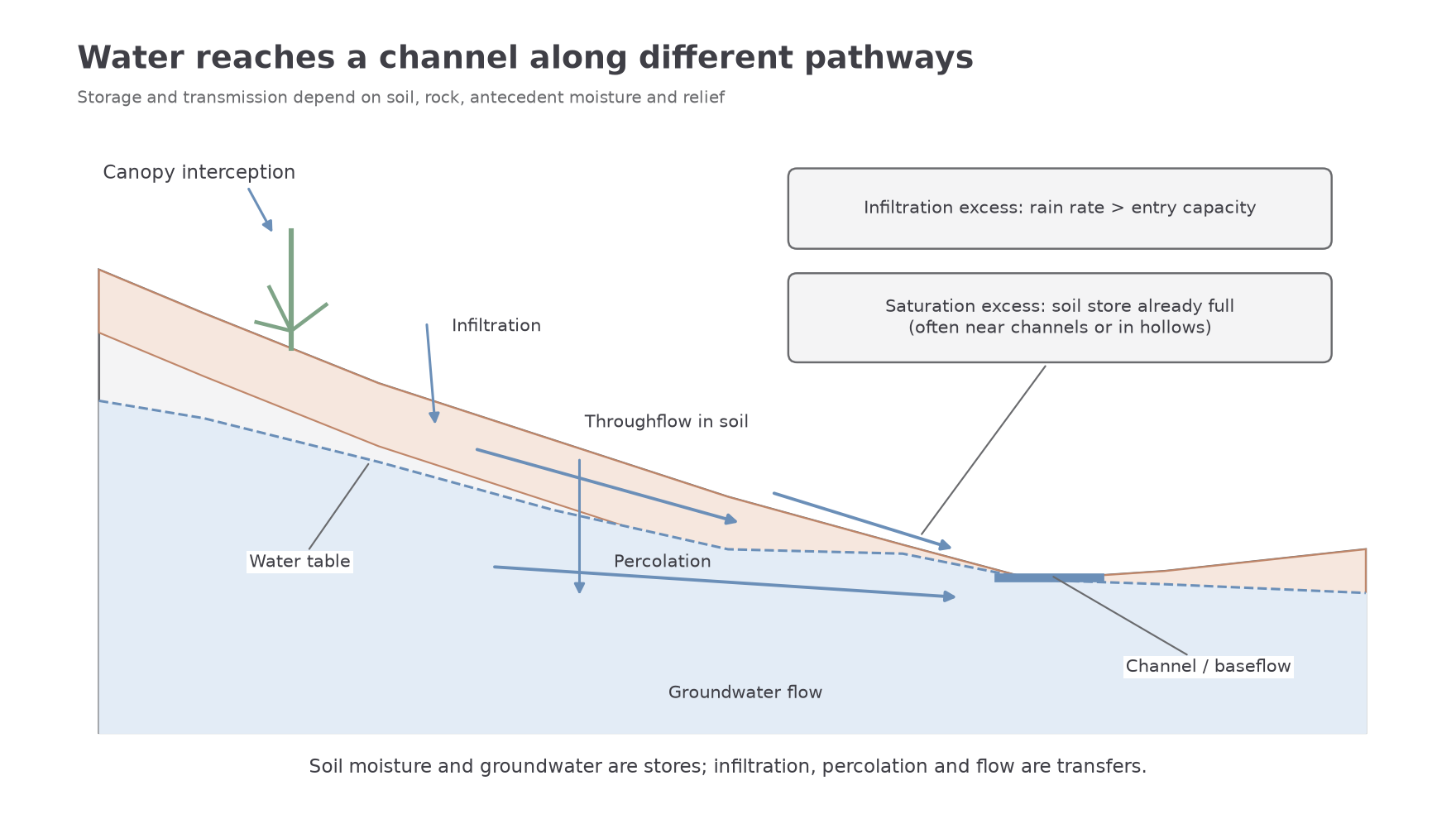
Relief affects gradients and the speed of connected flows, while permeable materials can delay water in larger subsurface stores. Antecedent moisture determines remaining storage before an event. A steep basin is not automatically flashy if much water infiltrates deeply; a gentle urban basin may respond rapidly through drains.
At Tanguro in the Upper Xingu, stream campaigns in 2007–2009, published by Hayhoe and colleagues in 2011, compared forest and soya headwaters. The 2013 research synthesis emphasised permeable deep soils and dominant baseflow even where farming increased water export. This real case shows why increased discharge can result from reduced evapotranspiration while substantial water still follows subsurface routes.
Field data should match the variable. An infiltration experiment can plot cumulative infiltrated depth against elapsed time; the curve's gradient gives infiltration rate. Compare replicated tests rather than one selected location.
Worked infiltration comparison
Illustrative dataset: a vegetated surface has final rates of 18, 20 and . Calculate its central value and spread:
A compacted surface has rates of 4, 7 and 7 in the same units:
The vegetated sample has the greater mean, but testing equal initial moisture and comparable soils is needed to isolate compaction's effect.
Worked rate from cumulative depth
An infiltration test's cumulative depth rises from 12 to 27 millimetres between minute 10 and minute 25. Find the gradient of that interval:
That is the interval's mean rate, which may exceed the later steady rate as soil storage fills. A dot plot of replicated final rates communicates variation better than two bars alone. Leakage and differing texture can limit causal conclusions.
Cryospheric processes and flow measurement
Snow and ice delay water transfers, while measured discharge expresses the volume moving past a point per unit time.
Snowfall can accumulate through winter; freezing stores liquid water as ice. During warmer periods, melting releases water, sometimes creating a seasonal discharge peak. Ablation means loss from a snow or ice store, including melting and sublimation; only the liquid melt component directly supplies meltwater runoff. Sublimation transfers ice directly to vapour. Glacier movement also transfers frozen water, and calving moves ice into a water body before it melts. A catchment can therefore release old stored water during a warm period with little concurrent rainfall.
Discharge and depth equivalent
Discharge is channel cross-sectional area multiplied by mean velocity. Its units are .
For constant mean discharge over time , is the volume and is its depth equivalent over the catchment. Use square metres for catchment area, seconds for time and multiply depth in metres by 1000 to obtain millimetres.
Worked glacial-river discharge
A river section has area and mean velocity . First calculate flow, then its daily volume:
For a catchment, convert area and divide:
This is discharged water spread over the basin, with snowmelt or storage release potentially contributing.
Worked two-hour outlet flow
A small drainage outlet has area and mean velocity over two hours. Multiply area by velocity and convert the interval to seconds:
Its contributing area is :
The depth applies to two hours, so it must not be compared directly with a whole-day rainfall total as if the intervals matched.
In a field measurement, estimate area from several depth readings and use a velocity method that represents the cross-section. A surface float can move faster than the cross-sectional mean, so it requires appropriate calibration. Changing discharge during sampling and an irregular bed introduce uncertainty. Do not extrapolate a brief reading across a day unless it reasonably estimates mean flow.