1.1.3 - Inherited wet and cold dryland landforms
Many present drylands contain landforms that began under wetter or colder climates. This lesson explains pluvial conditions, alternative pathways to inselberg and pediment formation, cold-climate debris and deposits, and the ways current processes and future climatic changes can modify inherited features.
Earlier pluvial climates
A pluvial interval has a wetter effective moisture balance than the conditions preceding or following it.
“Wetter” need not mean tropical rainfall. Greater precipitation can increase water supply, while lower temperature can reduce potential evapotranspiration. Together they increase runoff, soil moisture or lake storage. A basin that now loses almost all incoming water through evaporation may formerly have maintained a larger lake and more persistent streams.
During colder Pleistocene intervals, parts of the south-western United States had greater effective moisture than today. Changes in atmospheric circulation and storm tracks altered precipitation, while cooler conditions reduced evaporative demand. The NPS Death Valley geology account, updated in 2022, describes large lakes during the last major ice age and their later loss as the climate warmed. The broader lesson is not that every desert everywhere became wet during every glacial interval: regional circulation, topography and distance from moisture sources produced different responses.
A lake balance helps explain the transition. If precipitation over the catchment and river inflow exceeded evaporation and other losses for a sustained period, the lake expanded. Warming or reduced inflow could reverse the balance, expose lake beds and concentrate salts. Wind could later redistribute exposed fine sediment. Present aeolian activity can thus depend on sediment stored during an earlier water-dominated interval.
Evidence for a pluvial history includes shorelines above a modern playa, layered lake sediments, fossils consistent with aquatic conditions and channels too large for usual present flows. A single temporary lake following a modern storm is insufficient to establish a long pluvial interval. Dating and several independent indicators help distinguish a sustained past water balance from an exceptional recent event.
Inselbergs and pediments
Inselbergs and pediments can preserve long histories in which weathering, erosion and rock resistance interacted under more than one climate.
An inselberg is an isolated bedrock hill rising above a lower surrounding surface. A pediment is a broad, gently sloping erosional bedrock surface at or near a mountain front, often with only a thin sediment cover. A thick body of deposited alluvium is a fan, not a pediment simply because it slopes gently.
One explanation emphasises deep weathering and stripping, sometimes called etchplanation. During a wetter interval, moisture penetrates joints and promotes chemical alteration. Closely jointed or less resistant rock becomes deeply weathered, while massive resistant rock remains relatively intact. Later erosion removes the weathered material and exposes an irregular bedrock surface. Resistant remnants stand above it as inselbergs. Removal of the weathered mantle can help reveal a low-gradient surface around them. Lithology and joint spacing therefore matter as much as a general label of “past wet climate”.
Another explanation emphasises mountain-front retreat. Weathering and mass movement weaken a steep front; streams and sheetwash remove debris at its foot. As the front retreats, an erosional surface can extend into the former upland. Lateral stream erosion may help bevel the surface, with a thin veneer of transported material left above the rock. Effective runoff during wetter intervals can enhance debris removal, while episodic present flows may continue the work.
[DIAGRAM: asset_name: Inherited bedrock surfaces; asset_slug: p19-inselberg-pediment; caption: Weathering and stripping can expose resistant remnants, while retreat can extend pediments.; description: Two schematic cross-sections contrast a wetter-stage weathering mantle around resistant bedrock and a later stripped surface with an inselberg and thin sediment veneer. Dashed lines show a former mountain front and the direction of retreat. Labels distinguish erosional bedrock from thick depositional fan sediment, and identify these as possible pathways rather than a universal sequence.]
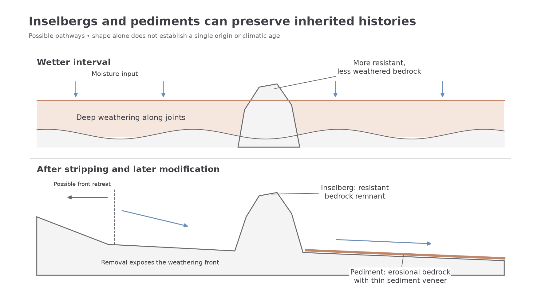
These are explanatory models, not mutually exclusive rules. A surface may inherit deep weathering, undergo later stripping and then be modified by stream erosion. Some pediments develop under arid conditions without requiring an earlier humid origin. USGS's Joshua Tree account discusses weathering, mountain retreat and removal of debris in explaining pediments and inselbergs. To evaluate a particular origin, examine weathering profiles, rock structure, deposits and dates rather than inferring an entire climatic history from shape alone.
Cold dryland processes and deposits
Formerly colder intervals extended frost and snow processes into areas that now experience warmer or drier surface conditions.
During the last glacial period of the Pleistocene, temperatures were lower than today in many mountain regions. Seasonal freezing lasted longer and snow could persist at lower altitudes, extending the area affected by cold-climate processes. The relevant conditions could occur on uplands above a dry basin even where the basin floor was not glaciated. A region's present aridity therefore does not mean that every landform within it developed through hot-desert processes. The 2014 NPS Great Basin inventory records a regional combination of dryland forms, alpine glacial evidence and periglacial features, including solifluction lobes in the Snake Range.
Frost-shattered debris forms where water enters rock weaknesses and freezing-related stresses, including ice growth, progressively detach fragments. Repetition supplies angular blocks and finer debris to slopes. A supply of liquid water and suitable freezing conditions are essential; severe cold in completely dry rock is insufficient. Angular scree alone is not a unique frost indicator because other weathering processes and rockfalls also produce angular material.
A nivation hollow develops beneath and around a persistent snow patch through a combination of weathering, meltwater erosion and downslope movement. Snow insulates the ground, while water and freeze-related processes around its margins can loosen material. Meltwater flushes fines away and slope movement removes debris, gradually enlarging a shallow hollow. It need not be excavated by a moving glacier and should not automatically be described as a cirque.
Solifluction is slow downslope movement of wet surface material, often enhanced where frozen or otherwise poorly permeable ground restricts drainage. Seasonal thaw can saturate the surface above colder ground; gravity then moves it downslope. Frost heave and subsequent settling can also contribute to net downslope movement. Repeated movement can build lobate, poorly sorted deposits. Permanent permafrost is not essential in every setting, but moisture, slope and impeded drainage must be explained.
When the climate changes, reduced process activity can leave hollows, debris mantles and lobes as relicts. Later vegetation or stable stone cover may help preserve them, while rare storms rework their edges. Preservation does not imply that every cold-climate process has ceased: some high-altitude sites remain active today.
Present and future modification
Inherited landforms continue to change, but the modifying process need not match the process that first created them.
Under current aridity, deep chemical weathering may be much slower than during a wetter interval. An exposed inselberg can instead lose blocks along joints through salt weathering, thermal stresses and rockfalls. Occasional intense rainfall may scour its foot and move debris across a pediment. If sediment supply exceeds removal, parts of the bedrock surface may become buried by alluvium; if flow becomes concentrated, channels may incise the veneer or bedrock. A stable-looking surface can consequently contain both long-preserved areas and recently reworked channels.
Cold-climate relicts have similar mixed histories. A nivation hollow may contain less persistent snow and be modified by runoff or soil development. A solifluction lobe may become vegetated and largely inactive, or its sediment may be cut by a gully. Frost-shattered debris can become a source for later debris flows, alluvial fans or dust. This is a transfer from an inherited store, not proof that present temperatures are producing the same debris at the same rate.
Future responses depend on the combination of temperature, precipitation, vegetation and sediment availability. Warming can increase PET and reduce snow duration. Fewer persistent snow patches may weaken nivation, but freeze-related weathering depends on water and the occurrence of suitable freezing conditions, so its response is not uniform at every altitude. Thawing frozen ground may initially increase instability before later drying or vegetation changes alter the response.
More intense rain, where it occurs, can increase erosive events; reduced rainfall can also reduce runoff and interrupt sediment supply. Drying that removes vegetation may increase aeolian mobility, yet prolonged lack of river supply may eventually starve dunes of new sand. The USGS 2004 dune discussion illustrates why moisture, vegetation and source supply interact. A justified forecast states the conditions, identifies a mechanism and acknowledges uncertainty over direction or rate, rather than claiming that all warming produces faster erosion everywhere.