1.1.3 - Water supply and dryland landscape change
Water-supply infrastructure can reorganise a dryland landscape by changing the timing of flows and the movement of sediment. This lesson uses the Colorado River, Glen Canyon Dam and Grand Canyon to explain the issue, trace changes to channels, sandbars and connected dunes, and assess the possibilities and limits of managed flood releases.
Water supply in the Colorado drylands
The Colorado River carries water from relatively moist mountain headwaters through dry regions where local precipitation alone cannot meet competing demands.
Mountain snow stores water seasonally and releases it during melting. Downstream, high evaporative demand and low rainfall limit local supply. Irrigated farming, towns, industry and recreation depend on water, while dams also support hydropower and regulate delivery. The Bureau of Reclamation's 2021 Colorado Basin report describes the basin's water-supply pressures and climatic risks. The relevant issue is both quantity and timing: demand can persist through dry seasons when unregulated flows would be low.
A reservoir stores water during higher inflows for release later. Glen Canyon Dam impounds Lake Powell upstream of Grand Canyon. The store buffers short-term differences between inflow and demand, but it does not create new water. If releases and evaporation exceed inflows over an extended drought, storage declines. A USGS 2004 account of Colorado drought documents the low-flow conditions and reservoir drawdown associated with the drought that began around 2000. This is a dated example of the balance problem, not a statement of present reservoir levels.
Drought means an unusually prolonged shortage relative to the area's normal conditions; aridity is a persistent climatic characteristic. The two can overlap, increasing pressure on an already limited supply. Reservoir operations respond to users' requirements, infrastructure and changing inflows. These human decisions then alter the downstream physical system. To explain the landscape effect, follow the change in discharge and sediment rather than stopping at a description of water scarcity.
Dams, diversions and system flows
A dam changes the downstream regime of water, sediment and energy, even when water continues to pass through it.
A natural snowmelt-fed river has seasonal discharge variation. Storing high inflows and releasing water according to supply and power needs generally reduces major seasonal peaks and changes low-flow conditions. Dam operations can also produce shorter-term fluctuations. An average annual discharge therefore cannot describe the whole geomorphic change: an erosive or depositional threshold may depend on the duration and magnitude of individual flows.
Water entering a reservoir slows and loses sediment. Coarse material is deposited first, and much finer sediment can settle within the reservoir. The NPS hydrological account, updated in 2015, records the closure of Glen Canyon Dam's diversion tunnels in 1963, the trapping of upstream sediment in Lake Powell and the altered flow regime through Grand Canyon. Water released downstream is consequently much less sediment-rich than the former river.
The two effects interact. Reduced flood peaks can limit the river's ability to mobilise coarse debris and deposit sand high along its margins. Yet comparatively sediment-poor water can still entrain existing channel and bar sediment where it has sufficient energy. Erosion of some stores can therefore occur alongside a reduction in very large floods. “The dam reduces erosion” is too broad: specify the reach, flow condition and sediment source.
Diversion for water use is a different intervention from temporary storage. It can remove water from a reach or return it later with changed timing. Both can alter discharge, but sediment response depends on where the intervention sits relative to sediment sources. At a system boundary around Lake Powell, trapped sediment is a growing store; at a boundary around downstream Grand Canyon, it represents an interrupted upstream input.
Sandbars, channels and connected dunes
Downstream landforms respond to a changed balance between the supply of sand and the flows capable of moving it.
Grand Canyon tributaries, including the Paria and Little Colorado rivers, continue to introduce sediment below Glen Canyon Dam. Sand can be stored on the main-river bed and redistributed to bars. Local eddies, channel constrictions and changing water levels influence where deposition occurs. A sandbar is consequently a temporary river store that can be built during one flow and eroded during later flows.
A National Park Service and USGS account published in 2022 connects these river stores to adjacent dunes. Once exposed bar sand dries, wind can blow it onto higher surfaces, including terraces and debris fans. Reduced bar replenishment limits the source; vegetation encroaching across the bar can further interrupt transport. Wind energy may remain available even though the pathway supplying a dune is weakened.
[DIAGRAM: asset_name: Dam regulation and river-to-dune transfer; asset_slug: p20-river-dune-transfer; caption: Reservoir trapping and regulated flows change the supply pathway from river sand to dunes.; description: A schematic sequence shows sediment settling in Lake Powell, sediment-poor water leaving Glen Canyon Dam, a tributary adding fresh sand downstream, deposition on a sandbar and subsequent wind transfer to an adjacent dune. Vegetation is shown as a possible barrier to the last transfer. A separate label states that tributary debris fans can still be supplied by their own flash floods.]
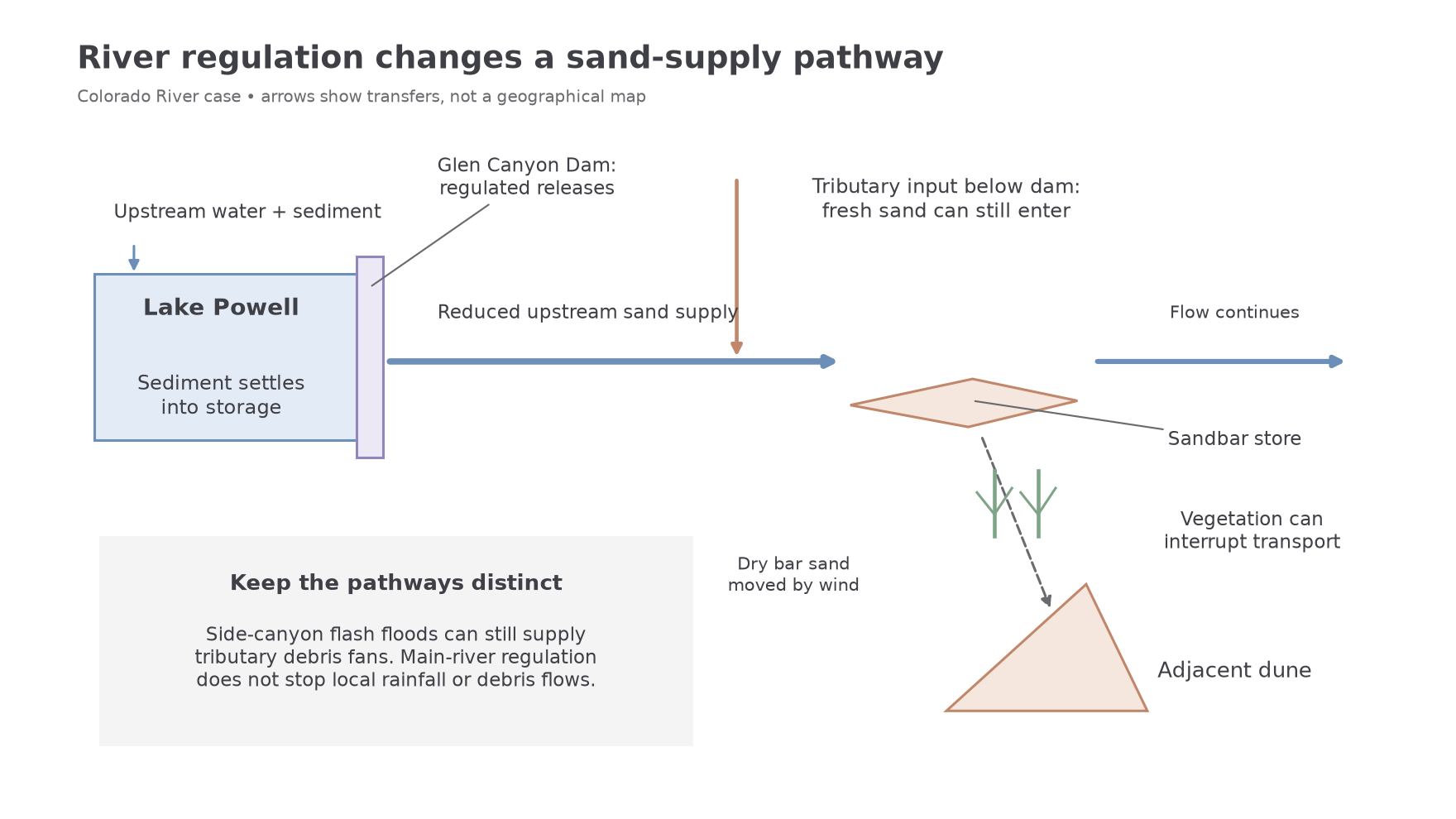
Distinguish main-river sandbars from tributary debris fans. Side-canyon flash floods and debris flows can deposit coarse material at tributary mouths, constricting the main river and influencing rapids and sandbar positions. Glen Canyon Dam regulates the main river upstream; it does not stop rain falling in these side catchments. Lower or less frequent main-river floods may be less able to rework tributary debris. It would therefore be inaccurate to claim that the dam prevents every downstream fan from forming.
A geomorphic explanation must retain these separate pathways: upstream sediment is trapped, tributary sediment still enters, regulated water redistributes it, and some exposed sand becomes an aeolian input. Changes to the dune can originate in river management even though the dune itself is not directly submerged by the river.
Landscape consequences and management
Managed releases can rebuild selected sediment stores, but their success depends on the material available within the regulated system.
A high-flow experiment, or HFE, temporarily increases releases from Glen Canyon Dam to mobilise sand stored downstream and deposit some of it higher along the river margins. Managers seek suitable tributary sand inputs before using a release; simply releasing more clear water can export scarce sand. The NPS account of the April 2023 HFE identifies rebuilding sandbars and beaches downstream of the Paria River as its aim. This is redistribution of existing downstream sand, not delivery of the upstream sediment trapped in Lake Powell.
Rebuilt bars can benefit campsites and provide sand that wind may move towards dunes and sediment-covered archaeological sites. The USGS account of sandbar rebuilding published in 2015 reports observed building under favourable sediment conditions in the initial releases under the 2012 protocol. Such observations support a limited success claim: experiments can rebuild bars, but do not establish permanent restoration of every store. Subsequent flows may erode them, tributary supply varies and vegetation can still block aeolian transfer. Repeat topographic surveys and sediment measurements are needed to assess retention after the initial release.
The landscape consequence extends beyond one bar. Dam storage changes water and sediment continuity along the river corridor, affecting channels, tributary confluences, bars and adjacent aeolian deposits. An HFE partially restores one process, while maintaining the reservoir and its wider water-supply role. Its performance should be judged against explicit objectives, such as bar volume retained and sand reaching connected dunes, rather than whether it recreates every pre-dam condition.
The case also demonstrates a wider dryland mechanism. If an abstraction or dam intercepts runoff and sediment from a fan's own source catchment, less material may reach its apex and fan growth may slow. Less runoff can reduce wadi discharge and the frequency of bed and bank erosion, slowing channel enlargement. If reduced runoff removes weathered debris less effectively from a mountain front, pediment extension may also slow. Conversely, if sediment supply falls more than transport energy, a channel may incise an existing deposit instead. These are conditional process pathways, not documented claims that all Grand Canyon fans or pediments have stopped developing. Coarse tributary supply, local storms and inherited surfaces require separate evidence. The boundary and position of an intervention determine which landforms it can affect.