1.1.1 - Managing a coastal sediment system
Coastal management can deliberately change sediment supply and let natural processes redistribute it. This lesson uses the Sand Motor on the Netherlands' Delfland coast to trace a nourishment strategy from its purpose through changed flows, landforms and landscape consequences. It also explains how repeated surveys and sediment budgets can establish whether the intended changes occurred.
The Sand Motor management strategy
The Sand Motor, or Zandmotor, is a large nourishment project on the North Sea coast of the Netherlands, between Hoek van Holland and Scheveningen. It lies on the Delfland coast, a different coastal landscape from the more northerly Wadden Sea. Its purpose is to strengthen coastal protection while creating opportunities for nature, recreation and research.
Nourishment adds sediment to a beach or nearshore system from another source. It replaces or supplements material that the local system would otherwise lack. At the Sand Motor, an artificial peninsula was created in 2011 using approximately million of sand. Rather than placing small quantities repeatedly along the full coast, managers concentrated a large supply at one location and intended waves, currents and wind to redistribute it. Rijkswaterstaat project account.
The rationale follows the system problem. Beaches and dunes provide a sedimentary buffer between the sea and low-lying land. Erosion and rising relative sea level can reduce the adequacy of that buffer. Adding sand increases the material available to maintain a protective profile. A large initial placement also aimed to reduce the repeated seabed disturbance associated with frequent smaller extraction and nourishment operations.
This is an intentional intervention: managers wanted to change flows and storage. The fact that waves subsequently do the work does not make it an unmanaged coast. People selected the source, volume, position and initial shape; natural forcing then determined how that imposed form evolved. Success must therefore be judged against protection and sediment-distribution objectives, not against keeping the original peninsula unchanged.
Nourishment and sediment redistribution
Nourishment changes the coastal system first by adding material and then by altering the geometry through which energy acts. The new peninsula projects into wave action. As sediment moves away from that projection, alongshore differences in transport can supply adjacent shores. Cross-shore exchange also moves sand among the beach, bars and shoreface.
At the scale of the receiving coast, imported sand is an input and raises the sediment budget. At the scale of the source seabed plus receiving coast, much of it is a transfer between stores. The selected boundary therefore changes the interpretation. Describing the Sand Motor as creating new sand would ignore the extraction area.
Wind provides another pathway. Dry, exposed sand can be entrained and transported inland. Where vegetation or topographic shelter traps it, dunes can grow. The pathway is conditional: moisture limits entrainment, and a lagoon or lake can intercept moving sand before it reaches the foredune. Dune growth cannot be predicted from beach width alone.
The scheme also changes energy distribution. An irregular shoreline changes the angle at which waves approach, while bars and shallow areas influence breaking and dissipation. Added beach sediment can provide space across which wave energy is dissipated before reaching dunes. Sand nourishment does not remove tides or storm energy; it changes how that energy interacts with the coastal profile.
[DIAGRAM: asset_name: Sand Motor redistribution geometry; asset_slug: p06-nourishment-redistribution; caption: A concentrated initial placement can feed a wider coastal profile as its central projection shrinks; description: Two schematic plan views compare an initial sand peninsula with a later lower projection and a wider spread along adjacent beaches. Arrows indicate alongshore redistribution and wind transport towards landward dunes. A lagoon is shown as a possible local sediment trap. This is a process diagram, not measured shoreline positions.]
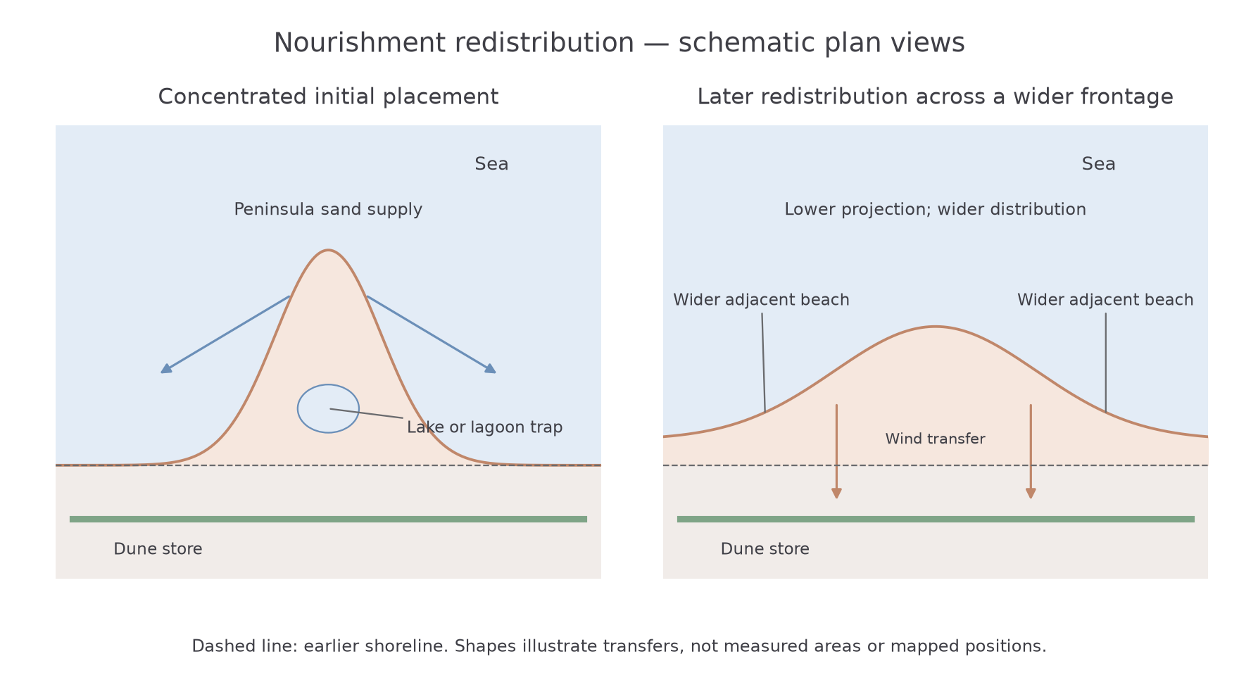
A useful comparison is a groyne. A groyne interrupts an existing alongshore transfer and can build the updrift beach while reducing supply downdrift. Nourishment initially increases supply to the receiving system. Either may change neighbouring stores, so the whole-cell consequences need assessment rather than judging only the managed frontage.
Changing beaches, dunes and coastline
The Sand Motor illustrates a landscape changing shape while its sediment remains partly within the managed coast. Initial placement extended the coastline seaward. Subsequent erosion of the projection and deposition around it spread the material over a longer frontage, producing a less concentrated shoreline form.
These changes can appear contradictory if each store is considered alone. A surveyed transect through the original tip may retreat, while a neighbouring transect advances. Together they can indicate redistribution rather than equivalent loss of protection. Cross-shore changes matter too: sediment moved below the visible waterline can remain in a protective nearshore profile.
The ten-year evaluation, covering 2011–2021, reports redistribution and dune development rather than a fixed final outline. It records slower initial dune growth than expected because the lagoon and dune lake intercepted wind-blown sediment. As these depressions infilled, the conditions for further transfer changed. The lesson is a geomorphic one: an added sediment store interacts with existing traps and pathways, so its effect is time-dependent. Deltares and partners, 2021 evaluation.
A beach profile may therefore broaden or build up without each point on it rising equally. Dunes can increase their sediment store while the beach supplies sand to them. A lagoon can shrink through deposition while creating a more continuous surface for later wind transport. These linked landforms together produce the changing coastal landscape.
The result is broader than a new beach outline. A seaward extension changes the position of the land–sea boundary, and sediment redistribution can create a larger coastal buffer. However, the contribution to protection depends on where the material is stored, its elevation and its response to extreme water levels. A large remaining volume in the wrong part of the profile is not sufficient evidence on its own.
Worked explanation of human influence
Explain how human activity influences the coastal landscape. At the Sand Motor, placing sand in 2011 extended the coastline seaward. Waves and currents then redistributed that additional supply onto neighbouring beaches, changing their profiles. Wind transferred exposed dry material towards dunes, although the lagoon initially intercepted some sand. Human input therefore changes the supply and starting geometry, while natural processes determine the resulting landform changes. Each change is connected to the intervention through a specific transfer.
Measuring management outcomes
Repeated topographic and seabed surveys allow managers to measure the location and quantity of sediment rather than relying on appearance. Beach and dune levels can be compared using a common elevation datum, while bathymetric surveys extend the comparison below water. The boundary should include the stores relevant to the objective and remain the same between survey dates.
A sediment budget applies conservation of material. If a central source loses sand, seek gains on adjacent beaches, the shoreface and dunes before calling it an external loss.
Worked survey residual
Illustrative dataset: the central projection loses million , adjacent beaches gain million , and the included lower shoreface gains million . First total the measured gains, then subtract them from the loss:
It could represent export beyond the survey boundary, unmeasured internal storage or combined measurement uncertainty. A budget residual is not automatically an exact measured offshore loss.
Worked final storage
A separate managed coastal area starts with million , imports million and exports million over the survey interval. Find the net transfer, then update storage:
The final total measures how much remains within the boundary. To judge protection, locate that volume across beach, dune and shoreface elevations too.
Likewise, apparent stability in a total volume can hide a profile becoming less protective. Volume results should be assessed alongside shoreline position, beach elevation, dune width and response to storms. Comparisons also need a suitable reference: a managed coast's favourable change does not establish what would have happened without intervention. Nearby comparison sections or process models can strengthen the explanation, with their limitations stated.
The Sand Motor's 2021 evaluation provides a decade of evidence, but ten years cannot directly establish performance under every future sea-level or storm condition. Monitoring tests predictions and can lead to adjustments. That is part of managing a dynamic system, rather than evidence that coastal change can be eliminated.
Worked comparison of management effectiveness
To what extent is management successful in influencing coastal landscape change? Success depends on the intended change and the spatial and temporal scale of assessment. The Sand Motor's 2011 placement of 21.5 million cubic metres created a large sand source whose erosion could support neighbouring beaches. Its 2011–2021 evaluation records redistribution and dune development, giving evidence that management altered several connected stores. Judging only retreat of the original tip would misclassify a planned transfer as failure. However, slower initial dune growth caused by lagoon interception shows that a larger supply does not determine a uniform response: pathways and traps influence where protection develops.
Compare Medmerry, completed in November 2013, where set-back defences and a controlled breach created 183 hectares of intertidal habitat. Here success includes allowing the former shoreline to change position and accommodating tidal processes. The Sand Motor increases supply on an exposed coast; Medmerry provides space for adjustment. Their outcomes cannot be ranked by the amount of shoreline advance alone. A protected asset, a wider dune buffer and new intertidal habitat are different objectives.
Both cases demonstrate strong influence over the starting boundary and sediment conditions, followed by continuing natural adjustment. Longer-term success requires surveys of connected stores, storm performance and maintenance needs. Overall, management can redirect coastal change substantially where the strategy fits local processes, but success is conditional on sediment connectivity, space and future forcing. The evidence supports managing a changing landscape more strongly than maintaining one permanent coastline. Environment Agency's 2014 Medmerry account.