1.1.1 - Coastal systems, energy and sediment
Coasts change because energy moves sediment through connected stores. This lesson explains coastal system boundaries, the influence of wind, waves, tides, rocks and ocean currents, and the origins of coastal sediment. You will also learn to calculate a sediment budget and explain why a beach can lose material even while sediment continues to arrive.
Coastal system components and boundaries
A coastal system is a set of connected landforms, sediment stores and processes operating within a chosen boundary. A useful boundary might surround one beach and its nearshore seabed, or a much longer coastline. The choice matters: sand moving from the beach into an offshore bar is an output from the beach alone, but an internal transfer if both stores are inside the boundary.
Sediment cell
A coastal area within which sediment is supplied, transferred between stores and eventually deposited or lost. Its boundaries often occur at major headlands or changes in transport direction, although sediment may cross them.
Inputs cross into the system. They include sediment delivered by a river, waves carrying energy towards shore and sand added by people. Processes transfer or transform material: erosion releases rock fragments, transport moves them and deposition adds them to a store. Outputs leave the boundary, such as fine sediment carried into deeper water. A store is the quantity held at a particular time, for example a beach, dune or nearshore sandbank.
Energy and sediment are connected but different. Wind transfers energy to waves; breaking waves dissipate energy through turbulence, friction and sediment movement. Gravity supplies the downslope drive for cliff collapse and the return of backwash. Sediment can circulate repeatedly between beach and seabed, whereas usable energy is continually supplied and dissipated. A diagram which makes sand disappear when a wave breaks confuses these two ideas.
A cell contains smaller subcells. A headland may strongly limit ordinary longshore transport but allow some material to bypass during storms. Very fine sediment can travel farther than shingle. Consequently, a cell is a useful model of relative connectivity rather than a perfectly sealed container. An intervention in one store may change another: retaining sand behind a groyne can reduce its delivery to the next beach.
The Netherlands' Sand Motor, constructed in 2011, shows why boundaries matter. Rijkswaterstaat placed about million of sand off the Delfland coast. That was an input to the receiving shore, but a transfer if the system includes both the extraction seabed and the shore. Waves, currents and wind then redistributed the material towards adjacent beaches and dunes. The project links an actual human input to natural transfers and protective stores. Rijkswaterstaat's 2023 project history.
Wind, waves and tides
Wind conditions control how much wave energy reaches a coast and the direction from which it arrives. Faster winds exert greater stress on the sea surface. Longer wind duration and a longer fetch, the distance of open water over which wind blows, allow waves to develop further. Frequent storms can prevent a beach recovering between erosive events; an occasional storm after a calm summer may encounter a larger protective beach.
Wind initially produces small ripples. Continued energy transfer develops larger waves with a measurable height, wavelength and period. In deep water, water particles mainly follow orbital paths: wave energy travels much farther than the individual water particles. As waves enter shallow water, interaction with the seabed reduces wave speed and wavelength. The wave steepens and eventually breaks. The resulting swash runs up the beach; backwash returns downslope.
Low-steepness waves often move sediment landwards and support beach recovery. Steeper storm waves can mobilise material and move it into offshore bars. These are tendencies, not two permanent wave species: local slope, sediment size, water level and wave period affect the outcome. Obliquely arriving waves can also generate an alongshore current and longshore drift, so wind direction matters as well as speed.
Tides are regular changes in sea level produced chiefly by the gravitational effects of the Moon and Sun together with the Earth–Moon system's motion. Many coasts experience approximately two high and two low tides each lunar day, but local basin geometry produces different tidal regimes. At spring tides, near new and full Moon, the lunar and solar effects combine to produce a larger range. At neap tides, around the quarter Moons, the range is smaller. Spring tides occur throughout the year.
Tidal range is the vertical difference between high and low tide. It changes how far waves and currents can act across a profile. High water may allow waves to reach a cliff toe previously protected by a wide beach. A larger tidal range usually exposes a broader intertidal zone on a gently sloping coast. Strong tidal currents through an inlet can maintain a channel even where nearby sheltered water allows mud to settle. A storm surge can temporarily raise water above the predicted tide, so the two must be distinguished.
Geology and ocean currents
The same wave conditions produce different landforms where rock properties and structures differ. Lithology means the physical and chemical character of the rock. Well-cemented sandstone may resist erosion more effectively than unconsolidated sand, while carbonate rocks can be weakened by chemical solution. Resistance also depends on weathering and fracture density; “hard rock” alone is an incomplete explanation.
Structure includes bedding planes, joints, faults and the orientation of rock units. Joints admit water and air and offer routes along which hydraulic pressure or weathering can weaken rock. Beds dipping seaward may favour sliding where a weak layer provides a slip surface. Permeable rock over relatively impermeable clay can concentrate water at the boundary, increasing pore pressure and reducing slope stability. Coastal form therefore reflects both marine attack and the way the slope supplies material.
Where alternating resistant and less resistant units meet the coast at an angle, differential erosion can produce headlands and bays. Where units run broadly parallel to the coast, a resistant outer band may shelter weaker material until breached. These are useful structural models, although real coastlines also inherit faults, valleys and past sea levels.
Large-scale ocean currents establish a wider setting. The five major subtropical gyres occupy the North and South Atlantic, North and South Pacific and Indian oceans. Their circulation is broadly clockwise in the Northern Hemisphere and anticlockwise in the Southern Hemisphere. Western-boundary currents such as the Gulf Stream and Kuroshio carry warm water towards higher latitudes; eastern-boundary currents such as the Canary, California, Benguela and Peru currents carry cooler water towards the equator. The Antarctic Circumpolar Current flows eastwards around Antarctica, while northern Indian Ocean surface circulation responds strongly to monsoon winds. NOAA's overview and map shows the global pattern.
These currents redistribute heat and can influence coastal temperature, moisture, biological production and the supply of marine sediment. Local tides, waves and nearshore circulation usually explain the movement of an individual beach's sand more directly than a distant ocean gyre. Scale matters: a global current provides context; it does not replace a local sediment-transport explanation.
Sediment sources and budgets
Coastal sediment comes from several sources, and its usefulness to a beach depends on its size and the route by which it arrives. Rivers deliver material eroded within a drainage basin; much fine sediment may remain suspended and pass a sandy beach. Weathering breaks down cliff rock, while mass movement brings debris downslope. Marine erosion releases sediment from cliffs and seabed. Wind can deposit land-derived sand at the coast, and longshore drift supplies one beach with material released farther alongshore. These are the terrestrial and alongshore supplies grouped in the specification, even though marine erosion is itself a coastal process.
An offshore seabed or sandbank can also supply material by marine deposition and onshore transport. This may be reworked older sediment rather than newly eroded rock. Beach nourishment is a human input: sand or shingle is moved from another source and placed on the shore. The source area loses material, so a gain within one boundary need not be a gain within a larger one.
For a clearly defined system and time interval:
where is change in sediment storage, is total input and is total output. If inputs and outputs are rates, the result is a rate of storage change; multiply by the elapsed time to find a quantity.
Worked annual budget
Illustrative dataset: river input is , cliff input , incoming drift , outgoing drift and deeper-water export .
First total the transfers in each direction:
Then apply conservation:
The negative result is a net loss from the combined stores during that year. The diagram places each measured transfer on the same boundary.
[DIAGRAM: asset_name: Illustrative coastal sediment budget; asset_slug: p01-coastal-budget; caption: Inputs and outputs are measured across the same boundary over one year; description: A bounded coastal sediment store receives river 25000, cliff 45000 and incoming drift 30000 cubic metres and loses outgoing drift 70000 and offshore export 50000 cubic metres. Total input is 100000 and total output 120000, giving storage change minus20000 cubic metres. All values are illustrative.]
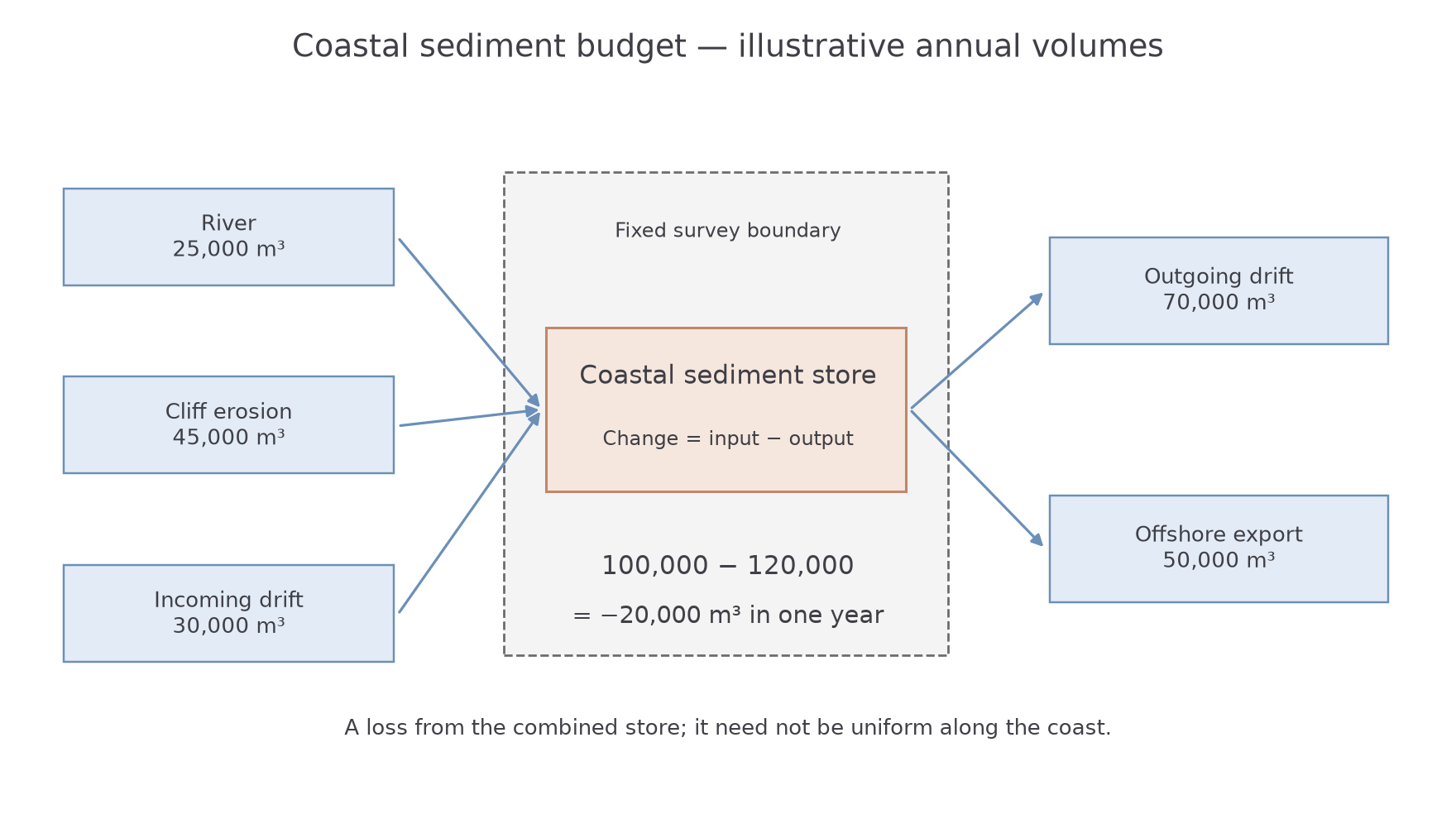
This is a mass-balance approach, although field budgets often use sediment volume. Volumes can be compared directly only if density and packing conventions are compatible. To calculate mass from volume, use mass equals density multiplied by volume and retain consistent units. A residual may also reflect survey error, an overlooked transfer or mismatched dates. A negative budget suggests loss of storage but does not prove that every part of a beach has narrowed equally.
Worked rate and storage calculation
A beach initially stores . It receives per month and loses per month for four months. First find the net monthly rate, then multiply by time:
Finally add the change to the initial store:
A transfer rate and a stored quantity use different units. Keeping those units visible prevents treating a monthly gain as the whole four-month change.