1.1.2 - Glacial systems and physical controls
Glaciated landscapes develop through linked stores and transfers of ice, water, sediment and energy. This lesson explains the system model, glacier mass balance and the effects of climate, geology, latitude, altitude, relief and aspect. You will learn to distinguish local ice gain from the balance of a whole glacier and to calculate changes using consistent units.
Glacial inputs, stores and outputs
A glacial landscape system contains connected ice, water and sediment stores within a chosen boundary. The glacier is one store, while snowfields, lakes, sediment beneath the ice and deposits in front of its margin form others. The area immediately beyond the ice is called the proglacial area; it remains connected through meltwater and sediment transfers.
Snowfall, wind-blown snow and avalanches can add material to the ice store. Rockfall from valley sides supplies debris to the glacier surface. Erosion beneath moving ice releases sediment that can be transported within or beneath the ice. Melting transfers ice into liquid water, while streams redistribute both water and sediment. Where the boundary includes a proglacial lake, water entering it is an internal transfer; where the boundary surrounds only the glacier, the same water is an output.
A glacial landscape system
An interconnected set of ice, water, rock and sediment stores, with inputs, outputs and processes transferring material and energy through a defined area.
Energy powers these processes. Solar radiation and exchanges with the atmosphere affect surface temperature and melt. Geothermal heat from below and friction associated with motion can influence basal conditions. Gravity provides the driving force for ice flow, slope failures and meltwater movement. Energy is supplied and dissipated, while material may pass through several stores before leaving the landscape.
A glacier therefore does more than erode bedrock. It transfers sediment and water into a wider landscape, where deposition can build moraines, fans and outwash surfaces. Some debris may remain stored for a long time before a flood remobilises it. A large sediment output in one season need not represent an equal amount of new erosion during that season.
Glacier mass balance
Glacier mass balance compares additions to and losses from a glacier over a stated interval. Accumulation adds mass, principally through snowfall but also through processes such as wind deposition, avalanching and refreezing of water retained within the glacier. Ablation removes mass through melting followed by runoff, sublimation and, where relevant, the loss of icebergs by calving.
Using positive quantities for accumulation and ablation:
where is net mass balance, is accumulation and is ablation over the same period and area. A positive result means net gain; a negative result means net loss.
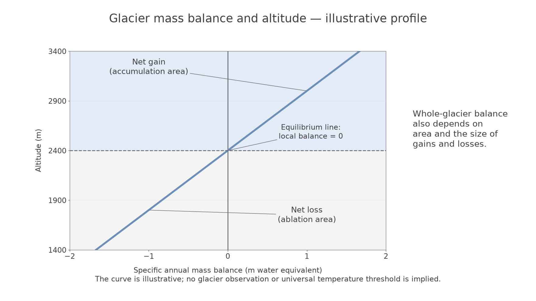
An accumulation area has a positive balance over the relevant balance year; an ablation area has a negative balance. The equilibrium line separates them where local accumulation equals local ablation. Its existence does not imply that the whole glacier has a zero balance. The areas on either side and the magnitude of their gains and losses matter.
[DIAGRAM: asset_name: Glacier mass balance and altitude; asset_slug: p08-mass-balance-altitude; caption: The equilibrium line is a local zero balance, not proof of a balanced whole glacier; description: An illustrative graph has specific annual mass balance in metres water equivalent on the horizontal axis and altitude on the vertical axis. Balance increases with altitude and crosses zero at an equilibrium line. Shading identifies the negative ablation zone and positive accumulation zone. It is not a measured glacier record.]
Balances are often expressed in metres water equivalent, the depth of liquid water containing the same mass per unit area. Snow depth alone is insufficient because fresh snow and compacted snow have different densities. For example, an illustrative snow layer with density represents , or water equivalent using water density .
A whole-glacier balance must be weighted by area. Large low-elevation losses can outweigh gains over a smaller upland area. USGS mass-balance data methods, 2022 explain how measured balances are combined with a glacier's area–altitude distribution.
Worked example — net gain over a balance year
Illustrative dataset: a glacier accumulates water equivalent and loses over the same year and area.
Accumulation exceeds ablation, so the result is a gain. Both quantities must refer to the same area, interval and units before subtraction.
Worked example — an area-weighted glacier
Illustrative dataset: a lower band of has a balance of water equivalent; an upper band of gains .
The larger lower band makes the glacier lose mass overall. Averaging the two band balances without weighting would give the wrong direction.
Gulkana Glacier in Alaska provides a real monitoring example. USGS began collecting its mass-balance, weather and water records in 1966. Its published 1997–2001 study records sustained negative balance, with pronounced thinning below the equilibrium line. Measurements across different heights are needed because a snowy upper glacier and a losing lower tongue can coexist. USGS Gulkana account and 2011 study of 1997–2001.
Persistent negative balance tends to thin the glacier and can cause the terminus to retreat, but the response may lag and depends on ice flow. Retreat describes a changing margin, not ice flowing uphill. Surface balance also differs from total balance where calving or basal losses are substantial.
Climate and geology
Climate influences a glacial system through both its supply of snow and the energy available for melting. A cold area with very little precipitation may accumulate ice slowly, whereas a snowy mountain can sustain a glacier at a lower latitude. Precipitation totals alone are insufficient: its form and timing determine whether it adds to the ice store.
Winter snowfall can remain until the next accumulation season, while rain may run off rapidly. Summer snow can temporarily raise surface reflectivity and reduce melt. Warm rain can also transfer heat and water into the system. Seasonal patterns therefore affect the timing of accumulation, meltwater discharge and sediment transport. A brief warm interval may produce a flood even if annual precipitation changes little.
Geology influences what moving ice can erode. Lithology is rock character: strength, mineral composition and grain structure affect resistance to abrasion and weathering. Geological structure includes joints, faults and bedding. Fractured rock offers blocks that can be loosened and removed, so strong but heavily jointed rock may erode differently from equally strong unfractured rock.
Permeability and drainage also matter. Water can enter fractures and sediments, influence basal water pressure and contribute to weathering or slope instability after ice retreat. Weak sediment beneath a glacier may deform and move with the ice, whereas a rigid bed provides a different sliding surface. A landscape explanation should therefore connect climate, ice movement and bed conditions rather than ranking “hard” and “soft” rock without mechanisms.
Latitude, altitude, relief and aspect
Latitude and altitude help determine where snow persists, but their effects operate through local energy and moisture conditions. Higher latitudes generally receive less annual solar energy and have colder conditions, allowing glaciers at lower elevations. At lower latitudes, glaciers are usually restricted to high mountains where temperatures are lower. Neither pattern removes the requirement for sufficient accumulation.
Temperature generally declines with height in the lower atmosphere, although the rate varies. Higher slopes can therefore retain snow while lower tongues lose mass. Orographic uplift can increase precipitation on a mountain's windward side, while rain-shadow conditions reduce supply on the lee side. Altitude influences both sides of the mass-balance equation through different pathways.
Aspect is the direction a slope faces. In the Northern Hemisphere, a sheltered north-facing hollow commonly receives less direct sunlight than a south-facing one, reducing melt; the broad solar contrast is reversed in the Southern Hemisphere. Shading by ridges, wind redistribution and avalanche supply can override a simple compass rule. These local conditions form a microclimate, a climate differing from the surrounding area at a small scale.
Relief influences snow concentration and movement. Hollows trap snow; steep walls can deliver avalanches and rockfall. Ice flows under gravity in response to its surface slope and thickness. A steeper or thicker glacier commonly has a larger driving stress, but actual speed also depends on thermal conditions, basal water and resistance at the bed and sides. Relief channels a valley glacier, whereas a sufficiently thick ice sheet can override much of the underlying topography.
These controls interact. A shaded hollow with wind-blown snow may initiate a glacier before an exposed ridge at the same altitude. The useful explanation states the pathway from location to accumulation, ablation or movement, rather than treating latitude or aspect as a process by itself.