1.1.1 - Coastal erosion and rock landforms
Coastal rock landforms develop through linked marine, atmospheric and slope processes. This lesson explains how weathering and mass movement interact with erosion, and how geology helps produce bays, headlands, cliffs, shore platforms, caves, arches, stacks, stumps, geos and blowholes. You will learn why a familiar sequence is a useful model without assuming that every headland passes through identical stages.
Weathering and mass movement
Weathering weakens rock in place, whereas mass movement transfers rock or sediment downslope under gravity. Neither requires the sea to carry the material away, but both can make wave erosion more effective by supplying loosened fragments and unstable slopes.
Mechanical weathering breaks rock without changing its minerals. In freeze–thaw weathering, water enters cracks, freezes and expands, helping fractures widen when conditions repeatedly cross the freezing point. Salt crystallisation can exert pressure as crystals grow within pores and cracks. Its effectiveness depends on salt supply, wetting and drying and rock porosity. A warm coast is therefore not protected from weathering simply because frost is rare.
Chemical weathering alters or dissolves minerals. Weakly acidic water can dissolve carbonate rock, enlarging joints and bedding-plane openings. Biological activity can also weaken rock: roots grow into existing cracks, while organisms and organic acids alter exposed surfaces. These mechanisms can work together, and their relative importance varies with temperature, water supply and rock character.
A slope fails when the downslope forces exceed its resisting strength. Waves may undercut the foot and remove support. Rainfall can saturate sediment, add weight and increase water pressure within pores, reducing the frictional resistance available along a potential failure surface. Rockfall is the rapid detachment and fall of blocks from a steep face. A slide moves material along a surface; rotational slumping follows a curved slip surface and can leave a stepped cliff profile. Very wet fine material may flow.
After failure, fallen debris can temporarily shield the cliff toe. Waves must remove or redistribute it before renewed undercutting becomes efficient. Consequently, cliff retreat can be episodic: a period of apparently little change may precede sudden collapse. It is the interaction between slope supply and marine removal, rather than one process alone, that explains the rate.
At Aldbrough on the Holderness coast, the British Geological Survey began monitoring landslides in 2001. Here roughly 20-metre cliffs of glacial sediment face the North Sea. Rainfall can raise pore pressure in the till while waves remove fallen material at the toe, connecting subaerial weakening to marine erosion. The BGS Aldbrough case study shows why monitoring both slope movement and the shoreline is useful.
Wave, river and wind erosion
Erosion removes material from its source, while transportation transfers the released material through the coastal system. Hydraulic action occurs when wave impact and pressure fluctuations act on rock weaknesses; compression of trapped air in suitable cracks can contribute. Abrasion occurs when sediment moved by water strikes or scrapes rock. Solution removes susceptible minerals chemically. Attrition, in contrast, is the collision and wearing down of transported particles rather than erosion of the cliff itself.
These processes depend on connected energy and material supplies. Large waves provide energy, but abrasion also needs suitable tools such as sand or pebbles. Very little sediment may limit abrasion; a thick beach can absorb wave energy and protect the cliff. More sediment therefore does not automatically mean more cliff erosion.
Rivers can incise valleys reaching the coast and deliver sediment to the shore. Their discharge can scour an inlet or help maintain a river mouth against marine deposition. Wind can lift dry fine grains, abrade exposed surfaces and transport sand towards dunes. Vegetation, surface moisture and grain size affect whether entrainment occurs. Wave transport may first deposit sand on a beach, after which drying and wind allow an aeolian transfer inland.
Deposition completes the link when transport capacity declines or sediment becomes trapped. A river-mouth bar, beach and dune can therefore contain material that has passed through fluvial, marine and aeolian stages. Calling a coastline “wave dominated” identifies a leading influence; it does not remove the other processes from its explanation.
Bays, headlands, cliffs and platforms
Bays and headlands often begin where rock units have different resistance to erosion. Less resistant sections retreat faster and form bays; more resistant sections project as headlands. Joints, faults and the orientation of beds influence where erosion starts, so lithology must be combined with structure.
As waves approach shallow water around a headland, the nearshore part of a wave slows first and the wave crest bends. This refraction tends to concentrate wave energy on projecting headlands and spread it around bays. It can reinforce the contrast produced by geology. Within a sheltered bay, reduced energy may allow sediment deposition and a beach to develop, linking an erosional outline with a depositional store.
At a cliff, repeated wave attack and abrasion can cut a notch near the level of effective wave action. Weathering weakens the face above and gravity brings unsupported material down. After the debris is removed, attack resumes against the new cliff line. Retreat leaves a gently sloping shore platform, often called a wave-cut platform, at the foot. Abrasion, hydraulic processes and subaerial weathering can all contribute to its surface.
[DIAGRAM: asset_name: Cliff retreat and shore platform; asset_slug: p02-cliff-platform; caption: Cliff retreat leaves a platform while fallen debris temporarily protects the toe; description: A schematic cross-section shows the present cliff behind a former dashed cliff line, a notch at the toe, a gently seaward-sloping shore platform, fallen blocks and incoming waves. Arrows show retreat landwards and debris removal seawards. It is an explanatory geometry, not a measured coast.]
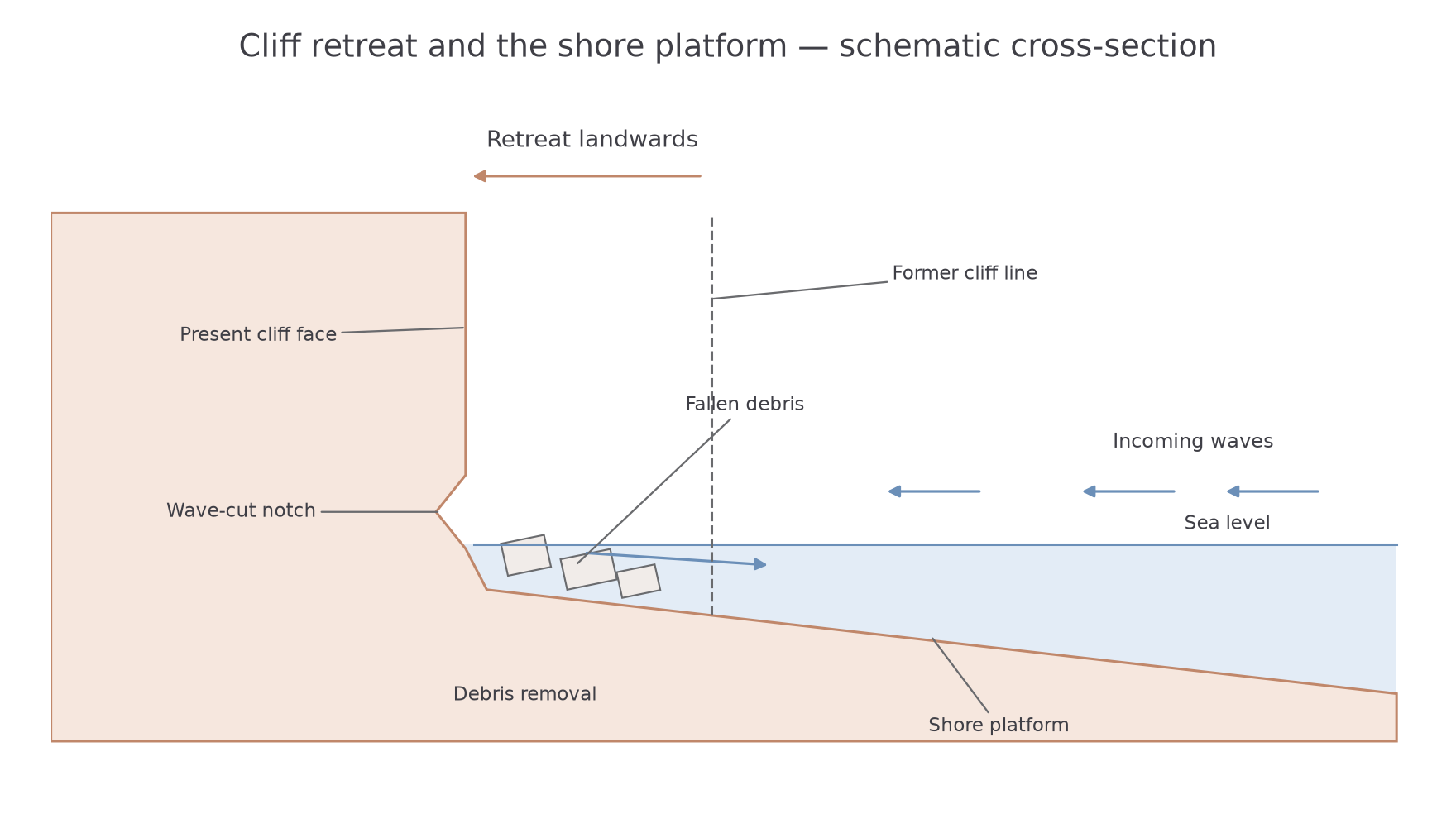
A widening platform can make further retreat harder because waves dissipate energy while crossing it, especially at low tide. High water and storms can restore access to the cliff toe. Platform development also depends on rock resistance, tidal range and sea-level history. A broad platform should not be explained by assuming one constant erosion rate throughout its existence.
Caves, arches, stacks and stumps
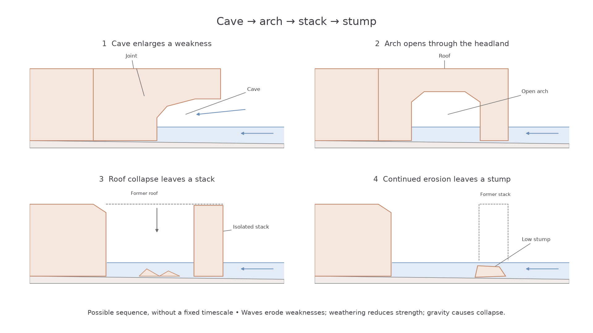
Caves develop where erosion exploits weaknesses in a cliff or headland. Hydraulic pressure and abrasion enlarge a joint, fault or weaker bed, while weathering widens fractures around the opening. Continued erosion can extend a cave into the headland. If it breaks through, or meets a cave advancing from the opposite side, an arch forms.
An arch roof is stressed by its own weight and weakened by weathering, joints and marine attack around its supports. Collapse can isolate a pillar called a stack from the retreating headland. Erosion and weathering of the stack can eventually leave a low remnant, or stump, sometimes exposed only at low tide. The fallen material becomes a temporary sediment store and may supply further abrasion tools.
This sequence explains a possible relationship among landforms, rather than a compulsory life cycle. A cave might never penetrate a thick headland. An arch roof may remain supported for a long interval, or fail during one storm. A stack can also be isolated by erosion along faults without a well-developed arch stage. Different forms observed together need not have formed at the same time or at the same rate.
[DIAGRAM: asset_name: Cave, arch, stack and stump sequence; asset_slug: p02-cave-arch-stack-stump; caption: Erosion enlarges weaknesses, roof collapse isolates a stack, and further erosion leaves a stump; description: Four schematic coastal side views show a cave entering a headland, an arch open through it, an isolated stack after roof collapse, and a low stump after the stack is reduced. Dashed roof outlines identify removed rock and arrows show the possible progression. Sea occupies the lower seaward space in each view.]
Worked landform explanation
In a photograph, a pillar separated from the cliff by open water is identified as a stack because it has no surviving roof connection. An explanation then traces the mechanism: hydraulic action and abrasion enlarge a weakness into a cave; penetration through the headland creates an arch; weathering weakens its roof and gravity causes collapse. That collapse isolates the pillar, whose exposed base continues to be eroded. An extended explanation adds the controls: joints determine the route of excavation, resistant rock can support a roof longer, and wave access governs removal of fallen debris. These links explain the form rather than merely listing stages.
Explain the influence of marine erosion on coastal rock landforms. At Old Harry Rocks near Studland in Dorset, jointed chalk contains openings, arches and isolated pillars. Wave impact applies hydraulic pressure to weaknesses, while moving sediment abrades exposed rock. Excavation widens openings and removes support; weathering enlarges fractures above the reach of waves, and gravity removes weakened roofs or blocks. The pillars are residual rock separated from the headland rather than piles of deposited sediment. Continuing attack at a pillar's base reduces support until collapse leaves a low remnant. The historical record identifies 1896 as the collapse of the original Old Harry's Wife, connecting the stack-to-stump transition to a dated event. Ian West's 2019 Southampton-hosted field guide reproduces the contemporary geological account. Chalk structure channels removal and wave energy supplies the work, so the resulting forms reflect their interaction rather than one universal rate of coastal retreat.
Geos and blowholes
Geos and blowholes develop where erosion follows connected weaknesses through coastal rock. A geo is a narrow, steep-sided inlet, often cut along a joint or fault. Waves repeatedly act on the weakness, and rockfall or other mass movement widens the opening. Collapse of a cave roof can also help produce an open chasm. Its narrow, linear outline records structural control more directly than the broad outline of a bay.
A blowhole is an opening linking the roof of a sea cave to the surface above. Weathering can enlarge a vertical joint while wave erosion works upwards from the cave. When the two connect, waves entering the cave can force air and spray through the opening. The spectacle is an effect of the connection; spray alone does not explain how the opening formed.
A blowhole roof may eventually collapse more widely, enlarging the inlet or contributing to a geo. This outcome depends on the position and strength of the remaining rock. Both forms illustrate feedback between marine excavation, weathering of fractures and gravitational failure. A convincing explanation identifies the weakness, traces how it enlarges and explains why the resulting geometry matches the landform.