1.1.1 - Sea-level change and inherited coasts
A coastline records earlier climates as well as present waves and tides. This lesson explains how changing sea level produces emergence and submergence, including raised beaches, marine terraces, abandoned cliffs, rias, fjords and shingle barriers. It also examines how modern processes and future climate change can modify those inherited landforms.
Climate and relative sea level
Sea level at a particular coast depends on movement of both the ocean surface and the land. Eustatic change is a change in global mean sea level, whereas relative sea level is the height of the sea compared with the adjacent land. Land uplift can make relative sea level fall even while the global ocean is rising.
During a previous cooling interval, such as the build-up towards the last glacial maximum around twenty thousand years ago, more water was stored in continental ice sheets. Removing water from the oceans lowered global sea level. Cooler seawater also occupies less volume than warmer seawater. Where land movement did not outweigh these changes, the shoreline moved seaward and formerly marine surfaces emerged.
Subsequent warming melted land-based ice and returned water to the oceans. Thermal expansion added to the rise as seawater warmed. Marine water moved into low coastal land and valleys where the local relative level rose. Melting floating sea ice has little direct effect on sea level because it already displaces seawater; land-based ice contributes additional water.
Isostatic adjustment complicates this history. A large ice sheet depresses the crust beneath it. After unloading, the land can rise gradually, producing relative emergence. Areas around the former ice load can respond differently. Tectonic uplift or subsidence and local sediment compaction can also affect a coast. Consequently, a global sea-level curve is not automatically a local coastal history.
Worked uplift calculation
Ocean level rises by while the land rises by . Take upward movement as positive, then subtract land movement from ocean movement:
The negative result is a relative fall of 0.2 metres. Both a cooler climate lowering global sea level and post-glacial uplift raising land can produce emergence, but their causes and timing differ.
Worked subsidence calculation
Ocean level rises by while land subsides by . First give downward land movement its negative sign, then use the same relationship:
The relative rise exceeds the ocean rise because the land is also moving down. This sign convention prevents incorrectly treating subsidence as uplift.
Raised beaches, terraces and abandoned cliffs
An emergent coastal landscape contains surfaces or deposits left above the level of effective marine action as relative sea level falls. Its features formed at an earlier shoreline before becoming separated from that active environment.
A raised beach is a former beach deposit now above the ordinary reach of the sea. Rounded and sorted marine sediment can help identify its origin. A marine terrace is a relatively level former coastal surface, commonly including a shore platform, left above the modern shoreline. A relict or abandoned cliff is the former cliff line behind it. These features are related, but a terrace need not consist entirely of beach sediment: a rock-cut platform and a deposit are different evidence.
While relative sea level was comparatively stable, wave attack, abrasion and weathering could develop a cliff and platform. A later relative fall shifted wave action seaward, leaving the old profile inland and higher than the new shore. Falling global sea level during cooling can create this arrangement. Uplift can preserve or raise it further. Repeated changes may create a flight of terraces, but their height alone does not provide a complete chronology: dating, geological structure and land movement must also be considered.
On the Ayrshire coast and Arran, NatureScot's 2019 landscape character description identifies raised-beach shelves backed by former cliff lines. This supplies a UK example of the visible assemblage. Its post-glacial setting must be explained through relative sea-level change, including uplift, rather than attributing every raised feature directly to cooling. NatureScot, Raised Beach Coast and Cliffs.
[DIAGRAM: asset_name: Emergent and drowned coastal profiles; asset_slug: p05-inherited-coasts; caption: Inherited erosion surfaces and valleys acquire different coastal forms as relative sea level changes; description: Three schematic cross-sections show an emergent coast with a raised beach on a marine terrace backed by an abandoned cliff, a drowned V-shaped river valley forming a ria, and a deep drowned U-shaped glacial trough forming a fjord. Former and present sea levels are labelled where relevant. These are explanatory profiles without numerical scale.]
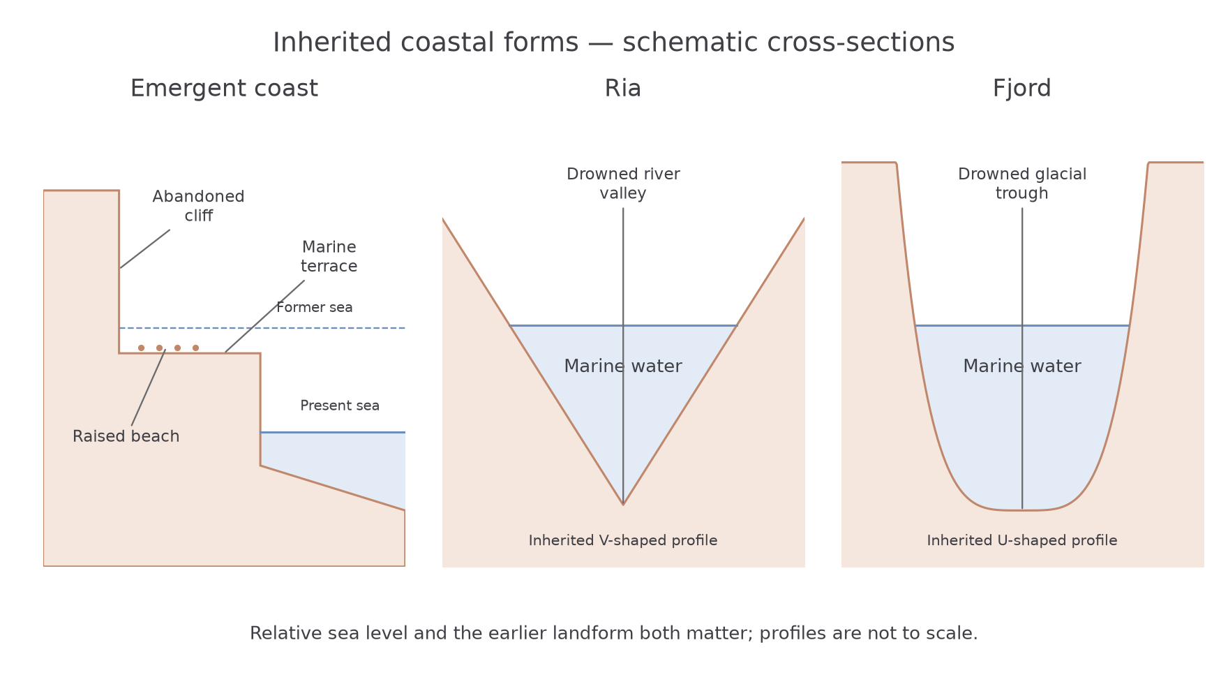
The strongest identification uses an assemblage: an old cliff, a bench and marine sediment together are more persuasive than a flat field alone. A similar-looking bench could have another origin. Coastal explanation combines form, material and history.
Rias, fjords and shingle beaches
Submergence allows marine water to occupy a pre-existing landscape, so the earlier landform strongly controls the shape of the resulting coast. Rising sea level supplies the inundation; it does not by itself excavate the entire valley.
A ria is a drowned river valley. River erosion first creates a valley and tributary network, commonly with a V-shaped cross-section. Later relative sea-level rise floods its lower part, producing an irregular, branching inlet. The Salcombe–Kingsbridge system in South Devon is a named example: the National Landscape's estuary account describes a drowned valley now fed by small streams rather than one large modern river. The present inflow therefore need not be capable of cutting the whole inherited valley. South Devon National Landscape estuary account.
A fjord is a drowned glacial trough. Glacial erosion deepens and widens a valley, often leaving a steep-sided U-shaped cross-section and an overdeepened basin. After ice retreat, marine inundation occupies the trough where relative sea level permits. A shallower threshold or sill may occur near its mouth. Geirangerfjord and Nærøyfjord in western Norway provide well-developed examples of this glacially inherited coastal form. UNESCO's West Norwegian Fjords account describes their glacial inheritance. Their glacial erosion history and subsequent relative sea-level history are both required in the explanation.
Shingle beaches and barriers develop differently. Rising water can rework gravel left on a formerly exposed shelf and move it towards the shore. Waves sort and accumulate it into ridges. Longshore sediment supply can also contribute. As sea level continues rising, overwash may carry material across a barrier crest and move the ridge landwards, sometimes enclosing a lagoon. Thus the landform is built by deposition within a changing sea-level setting, rather than being a drowned beach in the same sense that a ria is a drowned valley.
The Defra/Environment Agency report Understanding Barrier Beaches (February 2008) discusses mixed offshore and terrestrial origins and landward rollover. It identifies Chesil, Dorset, among barriers that have largely lost contact with an original offshore source. That limits any assumption of unlimited modern gravel replenishment. Understanding Barrier Beaches. Sea-level rise, sediment supply and the capacity to migrate must be considered together.
Present and future modification
Inherited coastal features continue to change after their original formation. On an emerged terrace, rainfall, chemical weathering, soil development and stream incision can alter the surface. An abandoned cliff may experience rockfall or become rounded and vegetated. Renewed relative sea-level rise can bring waves back towards its foot if the intervening ground is sufficiently low.
In a ria or fjord, modern waves, tidal currents, river inputs and slope processes modify the inherited shape. Fine sediment can accumulate in sheltered water, while currents maintain or deepen channels. Rainfall-driven slope failures can supply debris to steep fjord margins. An inlet therefore records an inherited valley overprinted by active marine and terrestrial processes.
A shingle barrier responds through erosion, overtopping, overwash and sediment redistribution. If there is room and sufficient material, landward migration can preserve a barrier as its position changes. Where a wall, steep slope or development blocks migration, rising water can narrow the available beach or increase flood risk. Exact responses depend on local sediment supply and storm sequences, so a universal retreat distance cannot be inferred from one sea-level rise figure.
The IPCC's 2021 assessment projects continued sea-level rise and identifies long-term commitment from ocean warming and ice-sheet loss. It does not predict an identical local shoreline response everywhere. IPCC AR6 Working Group I, Summary for Policymakers, section B.5. Future relative change also depends on uplift, subsidence and management. A coast can experience increased marine attack even where the inherited landform itself formed thousands of years earlier.