1.1.1 - Port development and unintended coastal change
Economic development can change coastal processes even when its main purpose is trade rather than erosion control. This lesson uses Rotterdam's Maasvlakte expansion and adjoining coastal system to connect port construction with changes in sediment, energy and landforms. It distinguishes direct reclamation, unintended geomorphic effects, predictions and measured outcomes.
Port expansion at Rotterdam
Rotterdam occupies a North Sea gateway to the Rhine–Meuse delta in the Netherlands. Its location connects ocean shipping with European inland transport networks. Port expansion at Maasvlakte provides space and access for commercial activities that require large sites, deep-water approaches and connections to their hinterland.
Land reclamation creates usable land by placing material within an area previously occupied by water. Maasvlakte 2 extended the port seaward, using extracted sand and new coastal defences to establish an industrial and transport landscape. The Rotterdam Mainport Development Project combined expansion with environmental compensation and monitoring. Its environmental impact assessments were completed in 2007, before construction began in 2008. Port of Rotterdam project account; Deltares monitoring synthesis, 2020.
The commercial purpose explains why the intervention occurred here. Accessible coastal land is valuable to port activities, and reclaiming offshore space can avoid some constraints of an already developed inland area. It also moves the boundary between land and sea and creates a new obstacle to waves and currents. The project is therefore an economic intervention within a coastal system, with geomorphic consequences extending beyond the intended creation of land.
Three effects need to be distinguished. Building land is an intended direct change. Constructing protection around it is also intended. Redistribution of sand along its curved frontage, erosion around a transition or altered seabed deposition can be secondary consequences of changed processes. Calling all newly created land an “unintended impact” would miss the specification's causal distinction.
Changing sediment and energy transfers
Port development changes sediment transfers by removing material from some stores and placing it in others. Sand extraction creates a depression in the source seabed; reclamation concentrates that sand behind a new shoreline. At the project scale, these are linked parts of one transfer. At the scale of the source area alone, extraction is an output.
The new geometry alters water movement. A projecting, curved shoreline changes the direction and concentration of wave approach. Refraction, breaking and alongshore currents respond to local depth and orientation, so neighbouring sections can experience different transport rates. Where more sand leaves a section than arrives, it erodes; where supply exceeds removal, it accumulates. The artificial land can be stable while its surrounding sandy defence remains mobile.
Dredging access channels also modifies bathymetry, the shape of the seabed. Changed depths can affect current speeds, wave transformation and the routes of suspended material. Resuspension during works may temporarily increase sediment in the water, while a deeper extraction pit can collect or redistribute particular sediment fractions. Actual direction and magnitude depend on the setting, so these mechanisms are hypotheses to test rather than automatic proof of beach erosion.
A 2019 Deltares study collected multibeam bathymetry, acoustic backscatter and seabed samples in and around Maasvlakte 2 sand-extraction pits. The combination matters: bathymetry measures shape, backscatter helps distinguish seabed character, and samples check the interpretation. Van Dijk and colleagues, 2019.
[DIAGRAM: asset_name: Curved reclaimed coast and sediment transfers; asset_slug: p07-curved-port-coast; caption: A new curved frontage changes alongshore and cross-shore connections; description: A schematic plan view shows reclaimed port land projecting into the sea, a curved sandy defence, incoming waves, alongshore sediment transfers and a nearby offshore extraction pit. A separate cross-shore transect illustrates the limited slice represented by a one-dimensional profile. No arrows represent measured transport magnitudes or an exact map.]
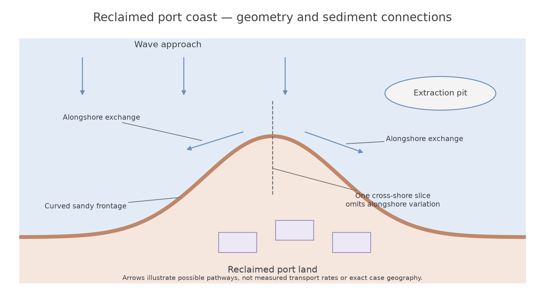
A sediment-cell explanation therefore follows material beyond the construction boundary. It asks whether sand has moved to a different included store, been exported, or required later replacement. It also distinguishes a brief construction disturbance from a continuing effect of the new coastal shape.
Landform and landscape consequences
Changes in transport alter landforms when they create an imbalance between sediment entering and leaving a particular store. At a convex sandy frontage, differences in wave angle and alongshore transport can remove sand from one section faster than cross-shore redistribution replaces it. A hard defence adjoining a mobile beach can create a further change in boundary conditions. The resulting erosion is a possible geomorphic cost of the constructed geometry, even though erosion is not the purpose of port development.
There is direct evidence of active change at Maasvlakte II. Attema, van Leeuwen and Kroon's 2023 research abstract analysed surveys taken before and after the early-2022 winter storms. They reported measured dune erosion reaching about per metre of coastline at some locations. This is a local maximum loss of volume per unit coastal length, not an average shoreline retreat of eighty metres. Netherlands Centre for Coastal Research, 2023.
The observation shows that a deliberately built coastal defence continues to adjust through erosion and transport. It does not establish that the port caused every component of the storm loss: the storms supplied the energy, while the constructed form influenced the response. Nor does dune loss prove that an equal sediment quantity left the whole coastal system. Some may be stored lower on the beach or shoreface.
At landscape scale, reclamation replaces marine space with industrial land and a new coastal edge. Subsequent beach and dune changes alter the profile that protects that land and can generate a need for nourishment. Thus economic development can both extend the coastline seawards directly and create continuing sediment-management requirements indirectly.
Other changes include compensatory coastal landforms. Spanjaards Duin was created in 2008–2009 on the Delfland coast to compensate for predicted damage to dune habitats associated with port use. Wind, rainfall, groundwater and vegetation subsequently shaped the nourished area. Its purpose was habitat compensation, so it should not be presented as accidental natural accretion caused by the port. Deltares project account.
Predictions and monitored outcomes
An environmental prediction states what a model or assessment expects under specified conditions, whereas monitoring records what subsequently happens. A reliable case study uses both, with their dates and limitations clearly identified.
Before reclamation, an impact assessment can model changes in waves, currents, silt movement and seabed form. Its results depend on assumptions about storm forcing, sediment, project design and timescale. A precautionary worst-case prediction is not a record of an observed outcome. The Port of Rotterdam's monitoring programme explicitly compares effects with its construction and operation assessments, including seabed morphology and silt transport.
Models can also be tested against a particular event. In the Maasvlakte II winter-2022 study, researchers compared measured dune erosion with one-dimensional and two-dimensional XBeach simulations. A one-dimensional model represents a cross-shore slice; a two-dimensional model also represents alongshore variation. Results differed especially at strongly curved coastal sections, supporting the importance of alongshore connections. Researchers also noted that nourishment after the storms complicated comparison of lower-profile measurements. That is a specific limitation, not a reason to reject all the evidence.
A good evaluation therefore states what is measured, where and when, then asks whether the proposed mechanism fits. A pre/post survey can show change, but storm severity, maintenance nourishment and pre-existing variability can complicate attribution. Comparable unmodified sections and tested process models can strengthen the inference. Measurements over a short interval cannot establish every century-scale effect.
The case supports a qualified judgement: economic development changes system boundaries and coastal geometry, with observed adjustment of sandy landforms and a continuing need to monitor sediment. It does not justify an invented claim that all neighbouring beaches suffered severe permanent retreat. Equally, protective engineering does not mean that natural sediment processes have ceased.