1.1.2 - Periglacial landscapes, climate and development
Cold ground can shape a landscape without a glacier occupying it. This lesson explains permafrost, patterned ground and pingos, and how climatic change modifies them. It then uses Alaska's North Slope to trace oil and gas development through altered heat and drainage to thaw, thermokarst and wider landscape change.
Cold climates and frozen ground
Periglacial landscapes are shaped by cold-climate ground processes, including freezing, thawing and the movement of water and sediment. They can occur near glaciers, but also far from them. The defining processes do not require the land to be covered by moving ice.
Permafrost
Ground that remains at or below for at least two consecutive years. It can include soil, sediment or bedrock and may contain large amounts of ground ice, little ice or almost none.
Permafrost is a thermal condition, not a synonym for a solid layer of pure ice. Above it, an active layer thaws in summer and refreezes in winter. Ground that freezes each winter but thaws completely each summer can have seasonal frost without underlying permafrost. These distinctions matter because thaw of ice-rich ground can cause much greater subsidence than warming of dry frozen rock.
Cooling before an advancing glacial phase could allow permafrost and frost-related processes to develop in exposed land ahead of the ice. Cold conditions after local retreat could also maintain a periglacial environment. Conversely, sufficient warming can deepen seasonal thaw or remove permafrost, leaving inherited features. A glacial period therefore contains a mosaic of ice-covered and exposed cold ground rather than one uniform surface.
Water movement is strongly affected by freezing. Frozen layers restrict infiltration and drainage, so the thawed surface can become saturated. Repeated freezing can draw water towards growing ice lenses and heave the ground. On slopes, saturated material may move slowly over frozen or otherwise restrictive ground, contributing to solifluction features. National Park Service permafrost-landscape explanation, checked 14 October 2026, describes these interacting ground processes.
Snow, vegetation and moisture modify the thermal regime. Snow can insulate the ground from severe winter cold, while surface vegetation and organic layers affect summer heat transfer. Latitude alone cannot predict the active-layer depth at every location. Local materials, drainage and insulation help explain why neighbouring surfaces respond differently to the same air temperature.
Patterned ground and pingos
Patterned ground develops where freezing and thawing repeatedly reorganise sediment or create patterned networks of ground ice. Similar-looking surface patterns can have different mechanisms, so their material and subsurface structure must be considered.
In sorted patterned ground, water migration towards freezing zones and ice-lens growth can heave finer sediment. Repeated heave, thaw settlement and displacement help concentrate larger stones around finer centres. Circles and polygons can form on gentle surfaces, while downslope movement can elongate the pattern into stripes on slopes. It is a gradual reorganisation through many cycles, not stones being sorted into rings by one snowfall.
Ice-wedge polygons have a different origin. Very cold winter conditions cause the ground to contract and crack. Meltwater later enters cracks and freezes. Repetition can widen wedges of ice beneath a polygonal network. Surface ridges or troughs reflect ground-ice growth and later modification. An ice-wedge polygon is not simply a large version of a sorted stone circle.
A pingo is a mound with a substantial ice core that raises the ground above it. In a closed-system example, drainage of a lake exposes a former lake bed. The unfrozen zone, or talik, beneath the lake begins to freeze around its edges and surface. Freezing confines and pressurises remaining groundwater, which is displaced towards a central area. Uplift and growth of an ice core raise the mound.
Parks Canada's account of pingos near Tuktoyaktuk explains this lake-drainage and groundwater-pressure pathway. It is a named formation example beyond the Alaska industrial case, not a claim that every pingo forms identically. Pingo Canadian Landmark formation account, checked 14 October 2026. Other pingos can be supplied by groundwater from outside their immediate mound system.
[DIAGRAM: asset_name: Ice-cored mound and thaw subsidence; asset_slug: p13-pingo-thermokarst; caption: Ground-ice growth can raise a mound, while loss of excess ground ice can create subsidence; description: Two schematic cross-sections contrast a pingo with an ice core beneath an uplifted sediment cover and an ice-rich surface affected by thaw settlement and ponding. Permafrost, active layer, ground ice, groundwater supply and heat input are labelled. The second panel shows the general thermokarst mechanism rather than a prediction that every pingo becomes a pond.]
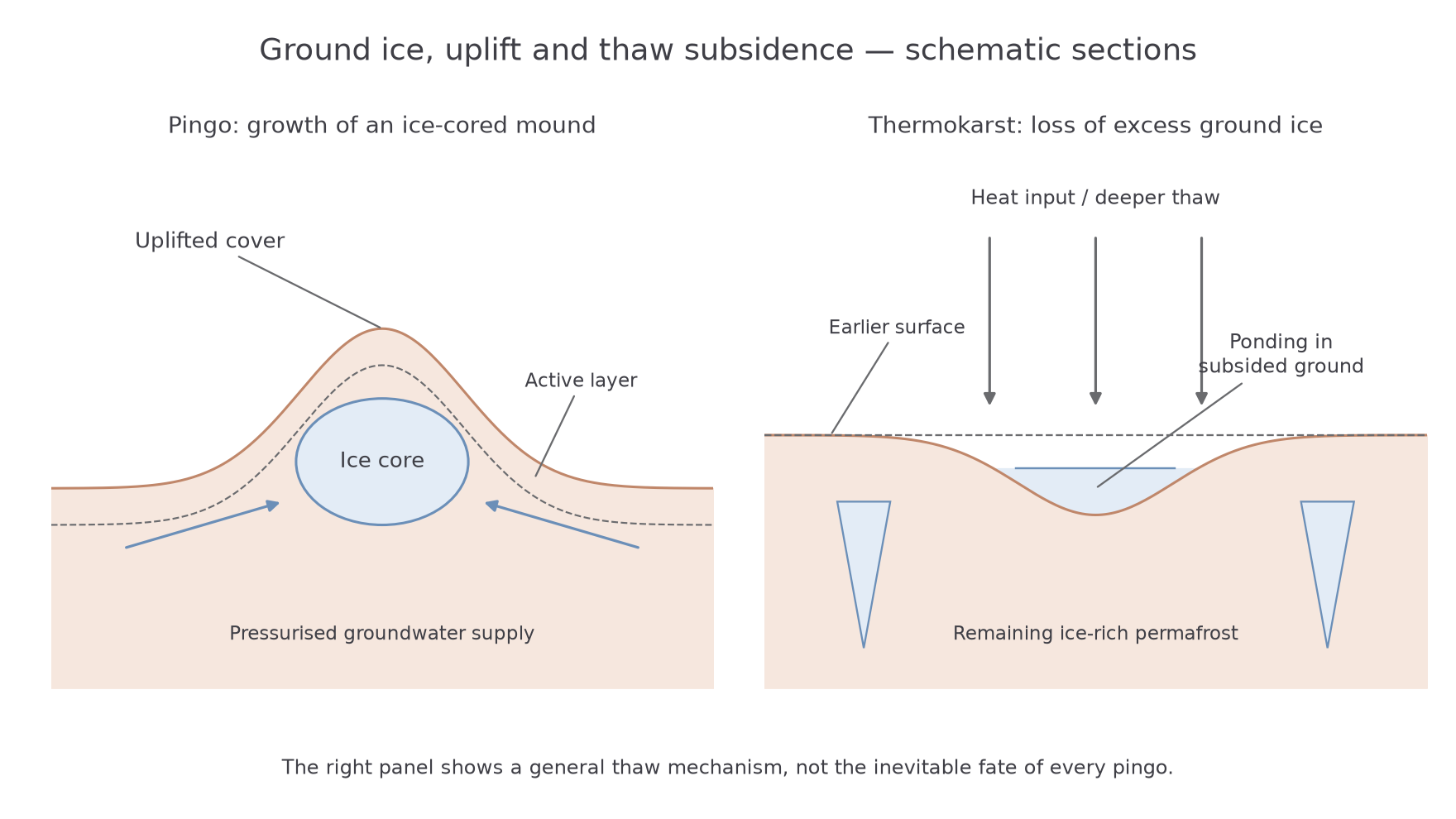
The common link is the movement and phase change of water within cold ground. The landform differs according to whether the main effect is sorting near the surface, growth along contraction cracks or concentrated ice-core uplift.
Past and future periglacial change
Periglacial landforms can persist after the climate that formed them has changed, but their future depends on whether they contain vulnerable ice. A stone pattern may remain after sorting becomes inactive, whereas an ice-cored mound may collapse when its core thaws.
Warming can lengthen the thaw season and deepen the active layer. Where ice wedges or other excess ground ice thaw, the surface can subside and collect water. Deeper water or changed drainage can then alter heat transfer, creating feedback between form and process. At some locations water drains away instead, drying the surface and changing vegetation. It is therefore inaccurate to predict universal waterlogging or universal drying across a permafrost region.
Pingos may crack as their cover stretches, exposing ice to warmer conditions. Thaw and erosion can reduce the mound or leave a depression and rim. Sorted ground can become less active as frost cycles weaken or as vegetation and soils stabilise it. Changes in snowfall can complicate the response because deeper winter insulation may reduce ground cooling even where summers change little.
The IPCC's 2021 assessment identifies observed permafrost warming and projected near-surface permafrost loss with further global warming, while recognising substantial local heterogeneity. IPCC AR6 Working Group I, chapter 9. This supports a direction of regional change, not one precise active-layer depth or collapse date for every pingo.
British relict periglacial features similarly record past cold conditions but are modified by present rainfall, streams, soil formation and human activity. A historical cooling period explains their formation; later warming explains why their processes may have weakened or ceased. An effective account distinguishes the formative climate, the surviving evidence and the processes acting now.
Alaskan development and system flows
Alaska's North Slope lies between the Brooks Range and Arctic coast. The Prudhoe Bay oilfield and the National Petroleum Reserve contain infrastructure built within tundra underlain by permafrost. Their exposed frozen ground differs from Greenland's ice-covered interior, allowing development to interact directly with periglacial processes.
Oil and gas development occurs because valuable subsurface resources can supply energy markets. Wells, processing facilities, access routes and pipelines allow extraction and transport, while settlements and employment connect the activity to a wider economy. These are the reasons for development; landscape changes follow through specific physical pathways rather than through economic growth acting directly on frozen ground.
Heated buildings or infrastructure can transfer energy into the ground if their design does not sufficiently isolate them. Removing vegetation and organic surface material changes insulation. Gravel roads and pads alter the surface energy balance, accumulate snow in new patterns and can obstruct drainage. Road dust can darken snow and affect melt timing; roadside ponding can change the transfer of heat and water into the ground.
Pipelines and crossings introduce further contrasts. Elevated or thermally protected structures can reduce direct heat transfer, while poorly maintained drainage around a road can still affect neighbouring ground. The effect therefore depends on construction, materials and operation, not simply whether a line on a map is called a pipeline.
A 2014 study by Raynolds and colleagues mapped infrastructure and landscape change at Prudhoe Bay over 1949–2011. It linked widespread thermokarst expansion with regional warming and identified road dust and roadside flooding as contributors to more extensive change beside roads and gravel pads. Original research. This evidence supports interacting climatic and local industrial influences, rather than attributing all thaw in Alaska to buildings.
The full causal chain is therefore activity, changed surface or drainage conditions, altered energy and water transfers, then modification of ice-rich ground. Each step is needed to explain the landscape consequence.
Thermokarst and landscape consequences
Thermokarst is an irregular landscape produced by thaw of ice-rich ground and the associated subsidence. Its name compares the pitted form with limestone karst, but the mechanism is melting of ground ice rather than dissolution of carbonate rock.
Where the active layer deepens into material containing excess ice, thaw removes a volume that the remaining sediment cannot fully replace. The surface settles unevenly because ice content varies. Ice-wedge troughs may deepen, small ponds may form and slopes can fail. If the ground contains little excess ice, thaw can occur with much less subsidence. Permafrost temperature and ice content therefore answer different questions.
At Prudhoe Bay, Raynolds and colleagues' 1949–2011 analysis records greater microrelief, ponding and erosion associated with expanding thermokarst. The broader change accelerated alongside warmer summer conditions after around 1990, while infrastructure-related effects operated locally. A comparison near and far from roads, combined with temperature records, is stronger evidence for attribution than a single photograph beside one building.
Once relief changes, water pathways change too. Ponding can focus further thaw, while a breached basin can drain and connect sediment to a channel. Newly exposed soil can erode, altering local sediment transfers. The consequence extends from an individual ice wedge to the arrangement of pools, drainage routes and slopes across the landscape, with implications for infrastructure as well as the terrain around it.
USGS research published in 2014 used radar observations and field measurements to examine seasonal thaw settlement in drained lake basins near Prudhoe Bay over 2006–2010. It demonstrates that deformation can be measured rather than inferred solely from appearance. USGS seasonal thaw-settlement study. Seasonal settlement must also be distinguished from a long-term lowering trend.
The landscape response is contingent: industry can amplify disturbance, climate can change the regional thermal setting, and local ice content governs how much ground collapse follows. These interacting controls explain why impacts vary within the same oilfield.