1.1.3 - Tourism and fragile dryland surfaces
Tourism brings people and vehicles into drylands whose surfaces may be more stable, and more vulnerable to disturbance, than their sparse vegetation suggests. This lesson uses Canyonlands and the surrounding Moab recreation landscape in Utah to explain how disturbance changes sediment transfers, channels and mobile sand, and why effective management must protect both surfaces and their recovery pathways.
Tourism in the Canyonlands drylands
Canyonlands and the wider Moab recreation landscape attract visitors to desert scenery, walking routes, cycling and motorised journeys.
Tourism is an economic activity because accommodation, guiding, equipment, transport and other services earn income from visitors. Access makes distant viewpoints and backcountry experiences possible, but also concentrates pressure at roads, trails, campsites and popular stopping places. Motorised access and walking need to be considered together: a vehicle may deliver many visitors to a site, and their subsequent movements can spread beyond the original route.
The National Park Service's White Rim Road description, updated on 13 July 2026, describes a 100-mile loop around and below the Island in the Sky mesa. It lists 20 individual campsites in 10 camping areas. Four-wheel-drive vehicles and bicycles use the route, with permits and designated-road requirements managing access. These are the published route and management arrangements, not measurements of erosion per visitor. The wider Moab recreation area contains different jurisdictions, so regional activity does not imply identical rules throughout it.
The physical issue is the relationship between use and surface resistance. Repeated travel on an established route may concentrate disturbance within a limited corridor. Informal shortcuts, widening around obstacles or vehicles leaving a route can create new strips of damaged surface. The area affected depends on behaviour, route design and substrate, rather than visitor numbers alone. Bare rock, loose sand, vegetated soil and biological crust respond differently to the same pressure.
This case therefore needs an explicit causal chain: demand for access leads to pressure on a particular surface; that changes the threshold for erosion or the route followed by runoff; sediment then moves to a new store or leaves the local system. Income or traffic by itself does not demonstrate a geomorphic consequence without this physical connection.
Vegetation, soil crusts and disturbance
A dryland surface can have important biological protection even where it has few large plants.
Biological soil crust
Also called cryptobiotic crust, this is a community of organisms, including cyanobacteria, lichens and mosses, living at or near the soil surface and binding mineral particles. It is living ground cover, distinct from a purely physical crust produced by compaction or salts.
Cyanobacterial filaments and associated binding substances help join grains. Rough crust surfaces can trap incoming dust, while roots and above-ground parts of larger plants reinforce soil, intercept rain and reduce wind stress close to the ground. Spaces between plants are therefore not necessarily unprotected. The NPS soil-crust explanation, updated in 2025, describes these organisms and their role in stabilising Canyonlands soils.
Footsteps, wheels and machinery apply compressional and shearing stresses. Dry, brittle crust can break; repeated passes crush or detach it and expose loose underlying particles. Vegetation damage reduces cover, and loss of roots can weaken binding over time. A disturbed strip thus changes the balance between the stress applied by wind or rain and the resistance of the surface. The wind need not become stronger for erosion to begin.
[DIAGRAM: asset_name: Intact and disturbed dryland surfaces; asset_slug: p21-crust-disturbance; caption: Surface disturbance can lower erosion resistance and connect runoff pathways.; description: Paired schematic cross-sections compare an intact rough biological crust with a plant and trapped dust against a broken crust crossed by a wheel track. Wind arrows show exposed particles becoming available for transport, while rain arrows converge along the disturbed strip into a rill. The diagram states that infiltration responses depend on soil and crust type.]
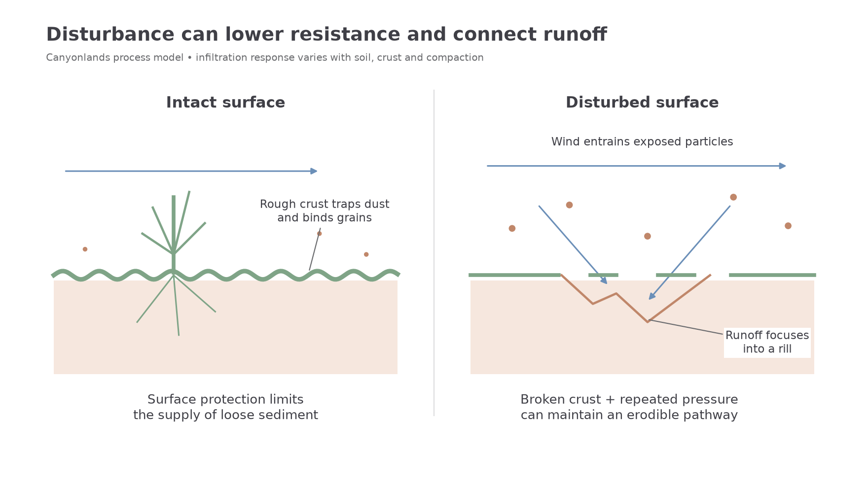
Water response is more complex than a universal claim that all crust removal reduces infiltration. Crust type, soil texture, roughness and compaction affect how water enters the ground. Wheels can compact some substrates and reduce pore space; a smooth track can also concentrate overland flow. In other settings, breaking a sealing layer may initially increase local infiltration. The robust explanation identifies the observed surface change and resulting flow, rather than assuming every crust has the same hydrological effect.
Changing erosion and landforms
Disturbance can change a dryland landscape by connecting loose sediment to wind and runoff pathways.
The NPS Disturbed Lands account, updated in April 2025, describes erosion along continuous tracks, rain-carved channels on slopes and mobilisation of formerly stable sandy surfaces. These are documented mechanisms and observations for Canyonlands, rather than an invented estimate of sediment lost per visitor.
On a sloping track, runoff can become concentrated in a narrow line. For the same catchment input, concentration increases flow depth and the stress applied to the bed. Water removes loose particles, creating a small rill. If the rill deepens and receives water from connected disturbed areas, it may develop into a larger channel. The channel itself then becomes a preferential pathway for later runoff. This positive feedback can extend the impact beyond the original footprint. It is conditional on slope, storm intensity and erodible material; a mark on hard bedrock will not behave like a track through loose soil.
Wind can remove pulverised crust and exposed fine material, leaving a coarser surface or transporting sand into neighbouring patches. Deposition may bury intact biological crust, reducing light available to its organisms and weakening another area of protection. Where extensive disturbance releases sufficient sand, previously stabilised sand can become mobile and build or reactivate dunes. A local footprint does not inevitably produce a large dune: the response requires a large enough supply and an effective transporting wind.
Different parts of the affected landscape can change in opposite ways. A track loses sediment, a nearby hollow receives it and a downwind sandy patch grows. A photograph of deposition at one point cannot establish that the whole landscape gained sediment. A useful sediment budget includes the eroding source, temporary deposits and material leaving the chosen boundary.
Worked resource application — disturbance and wind transport
Illustrative observations compare two adjoining sandy plots during the same wind event.
| Plot | Surface condition | Observed sand movement |
|---|---|---|
| A | Intact biological crust between plants | Little movement across the surface |
| B | Repeated wheel tracks, broken crust and loose grains | Sand moving away from the tracks |
Referring to the table, suggest how human activity has influenced wind transport. Repeated wheel passage has broken the binding crust in B, exposing grains that remain protected in A. This lowers the stress needed for entrainment, allowing the same wind event to move more sand from B. The difference suggests that disturbance has increased sediment availability rather than requiring a stronger wind. It identifies a plausible mechanism supported by the supplied comparison; substrate and exposure should also be checked before estimating the size of the effect.
Dust transfers and landscape consequences
Fine sediment can carry the effects of disturbance beyond the original recreation site, while management changes both sediment supply and connectivity.
Dust lost from a source can remove mineral nutrients and fine material that helps retain moisture. At a receiving site, deposition can contribute to soil development. The NPS account From Dust to Crust, updated in 2025, describes dust trapping and soil enrichment in Canyonlands. It also stresses the importance of retaining that sediment. Dust is therefore neither universally harmful nor universally beneficial: the consequences differ between eroding and receiving stores.
Over long periods, repeated wind-blown silt deposition can produce loess, often beyond or around dryland source regions. This is a general depositional possibility, not evidence that a named Canyonlands tourist track has created a measured loess deposit. Establishing such a claim would require sediment tracing, grain-size evidence, dates and a quantified source–sink link. Local observations of damaged crust demonstrate a pathway to increased mobility without proving the destination of every grain.
Management can interrupt the chain near its source. Keeping use on a well-designed existing route protects adjacent crust; closing unnecessary tracks reduces repeated breakage and allows recovery. Directing water away from long uninterrupted track slopes can limit runoff concentration. However, a badly placed drainage outlet may transfer erosion to a new site. Surfacing a small access area may reduce dispersed damage while changing runoff, so effectiveness should be assessed over the surrounding catchment rather than only the hardened strip.
Recovery is limited by biological growth, water availability and continued disturbance. It can take years to decades and varies with the organisms and site conditions. A closed track may continue exporting sediment while its surface remains loose. Repeated foot or wheel pressure can reset recovery, so fencing or a sign succeeds physically only if it changes use and protects the recovering surface. Monitoring can compare repeated photographs, crust cover, rill dimensions and collected sediment with an appropriate undisturbed control. Differences in slope or substrate must be considered before attributing all change to access management.
The best-supported judgement is conditional: route concentration and protection can reduce new sediment sources and reconnect biological stabilisation, but existing channels, legacy mobile sand and slow recovery may keep impacts visible long after pressure is reduced.
Worked argument — managing dryland tourism impacts
Assess the relative importance of surface protection and runoff management in reducing the impacts of tourism on a dryland landscape. In Canyonlands and the wider Moab landscape, protecting intact surfaces is generally the most effective first step because disturbance can create sediment sources that persist long after a visitor leaves. Runoff management becomes particularly important where earlier tracks already connect those sources to channels.
The scale of organised access is visible in the NPS July 2026 White Rim account: the 100-mile road loop serves 20 campsites arranged in 10 areas, with permits and designated-road requirements. Concentrating travel can protect the much larger area of intact ground between routes. This matters because sparse vascular plants conceal biological crust that binds grains and traps dust. A visitor or wheel leaving the route can break that protection and expose material to wind, even if the climate has not changed. Surface protection acts at the beginning of the causal chain, preventing a new supply of mobile sediment rather than trying to collect it after erosion begins.
Its importance is strengthened by slow recovery. The NPS 2025 soil-crust account describes development of the full community over decades and potentially a century; its dust-to-crust account describes healthy crust formation taking up to half a century. These are context-dependent descriptions, not one guaranteed recovery time for every damaged patch. They show why avoiding new damage has a different timescale from repairing it. Closing an unnecessary track prevents repeated disturbance, but organisms must recolonise while exposed grains remain vulnerable. Signs and permits therefore matter physically when they change behaviour, rather than through their existence alone.
However, surface protection cannot immediately remove an established drainage pathway. The NPS April 2025 disturbed-lands account describes rain cutting channels along continuous tracks and wind mobilising formerly stable sand. A long sloping track concentrates runoff, increasing depth and bed stress. Once a rill forms, later storms can reuse it even after access stops. Diverting flow away from long uninterrupted slopes or stabilising a vulnerable crossing can therefore reduce continuing export more quickly than biological recovery alone. Poorly placed outlets can transfer erosion to a fresh location, so the judgement must include the receiving slope and channel rather than only the treated road surface.
The approaches consequently reinforce each other. Route design and compliance protect intact sources, while targeted drainage treatment addresses concentrated flows on damaged corridors. Their relative importance varies with substrate: a bedrock route has less loose soil to protect than a sandy crusted surface, and a level site has less potential for rill incision than a steep track. Comparable storm surveys, crust-cover records and sediment measurements would test whether the selected combination reduces erosion over time.
Overall, surface protection has the greater long-term importance where intact biological cover remains, because it avoids initiating a slow and uncertain recovery. Runoff management is essential in already connected erosion corridors. Successful management therefore matches intervention to the stage of disturbance, preserving stable ground while interrupting the water and sediment pathways sustaining legacy impacts.