1.1.3 - Dryland dunes, fans and bajadas
Dryland deposition creates different landforms according to the material supplied and the way wind or water loses its transporting power. This lesson explains dune growth and migration, compares barchan, linear and star dunes, and connects alluvial fans and bajadas to measurable sediment budgets.
Dune formation and migration
A dune is an accumulation of wind-deposited sand whose shape changes through erosion, transport and deposition.
A source such as a dry river bed, beach or exposed sandy deposit supplies grains. Wind must exceed their entrainment threshold and carry them towards a place where some are deposited. A small obstacle or patch of rough ground can trap sand; the growing mound then changes airflow and promotes further accumulation. Dunes can also develop through instabilities in sand transport without a single large obstacle. Vegetation may trap sand but, if dense enough, can stabilise the surface and restrict migration.
On a simple migrating dune, sand is eroded from the gently sloping stoss, or windward, side. Saltating grains move up the slope and over the crest. Airflow slows or separates on the sheltered lee side, allowing deposition. Accumulated grains periodically avalanche down a steeper slip face when the slope becomes unstable. Sand is transferred from the upwind side to the downwind side, so the dune migrates even though individual grains move by short hops.
Migration is not the same as growth. A dune can maintain approximately the same volume while moving downwind if inputs and outputs balance. It grows if net deposition is positive and shrinks if removal exceeds supply. A strong wind may erode a sand-starved dune rather than enlarge it.
Repeated mapping estimates a mean crest-displacement rate by dividing distance moved by the elapsed time. Georeferencing error, changing crest shape and different wind directions can affect the estimate. The USGS 2004 discussion of desert dunes emphasises interactions between supply, wind and climatic conditions.
Worked example — comparing crest positions
Illustrative survey: the same identifiable crest shifts 26 metres downwind between images taken two years apart.
This is movement of the mapped crest, not an estimate of additional sand volume.
Worked example — a longer interval
Illustrative survey: a different dune crest moves 35 metres between surveys seven years apart.
The average may combine years of rapid movement and years of little change. Comparable control points and the same crest definition are needed before interpreting the distance as migration.
Barchans, linear dunes and star dunes
Dune shape records the interaction between effective wind directions, sand supply and the surface on which sand moves.
A barchan is a crescent-shaped dune commonly associated with limited sand supply, a relatively firm exposed surface and one dominant sand-moving wind direction. Its horns point downwind: the thinner edges contain less sand and can advance faster than the thicker central body. The steep slip face lies on the sheltered side inside the crescent. A barchan's horns should not be confused with the upwind-pointing arms of a vegetation-anchored parabolic dune.
A linear dune is a long, narrow ridge. Many form where two effective wind directions approach obliquely from different sides. Sand is moved along the ridge and redistributed across it; the ridge commonly extends approximately along the resultant transport direction. Vegetation, sand availability and the relative strength of the winds produce variations. “Linear” describes the morphology, so it should not be treated as proof of one universal formation mechanism.
A star dune has several arms radiating from a high central mound. Multiple sand-moving wind directions build different slip faces at different times. Where sand is abundant, deposition can build the dune upwards rather than producing a simple steady translation in one direction. A star dune is not simply a barchan drawn from a different angle.
[DIAGRAM: asset_name: Comparing dryland dune forms; asset_slug: p17-dune-forms; caption: Barchan, linear and star dunes reflect contrasting wind regimes and sand supply.; description: Three schematic plan views show a crescentic barchan with horns pointing downwind, a long linear ridge with two oblique effective winds, and a star dune with several radiating arms and multiple effective wind directions. A separate cross-section shows windward sand transport over a crest and deposition on the steeper lee slip face.]
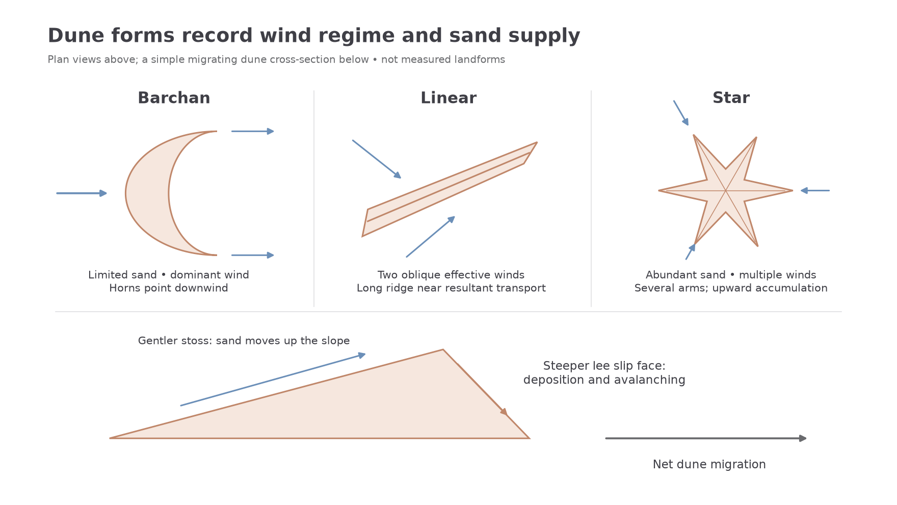
Wind direction here means the winds that actually transport sand, not every breeze recorded at a weather station. A useful explanation combines form, transport direction and supply. A photograph of a crescent is weaker evidence than repeated surveys showing its horns migrating with the dominant transporting wind.
The NPS account updated on 23 January 2024 identifies crescent, linear and star dunes together at Mesquite Flat near Stovepipe Wells in Death Valley. It reports that the highest dune rises about 100 feet, approximately 30 metres. This named assemblage shows that local wind pathways and sediment trapping can produce several forms within one dune field; the region's aridity alone does not select a single shape. NPS, Sand Dunes.
Alluvial fans
An alluvial fan is a fan-shaped body of sediment deposited where a confined flow enters a more open area and loses some of its ability to transport its load.
A canyon confines water and sediment into a relatively narrow channel. At the mountain front, flow can spread laterally across a basin floor. A lower gradient, reduced flow depth and water loss through infiltration can reduce transport competence, the largest particle size that can be moved, and capacity, the total load that can be carried. Sediment is deposited around the channel mouth, or fan apex.
Different events add different deposits. A water-rich flash flood can sort sediment and build channels or gravel bars. A debris flow contains a high concentration of sediment and can leave poorly sorted lobes containing large clasts within finer material. One event cannot be assumed to sort the whole fan neatly from coarse at the top to fine at the bottom. Repeated flows abandon some channels and occupy others as deposited sediment raises the bed or blocks a route. This channel switching, or avulsion, distributes sediment across the fan.
[DIAGRAM: asset_name: Alluvial fans and a bajada; asset_slug: p17-fans-bajada; caption: Individual fans grow from canyon mouths and may merge into a bajada.; description: A schematic plan view shows mountain catchments feeding confined canyons, fan apices at the mountain front, spreading distributary channels and adjacent fans joining along the basin margin. A cross-section distinguishes thick fan sediment from an erosional bedrock pediment with only a thin surface veneer.]
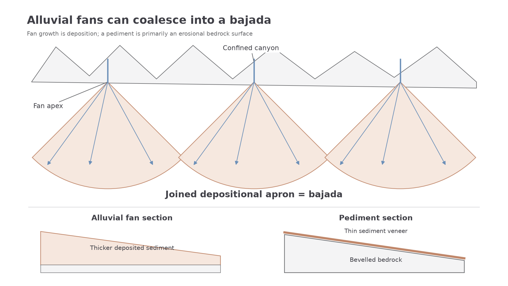
Fan activity depends on both sediment and water. A sediment-rich flood may deposit a lobe, while a later flow with relatively little sediment may incise the existing fan. Changes in uplift, base level, climate or vegetation alter that balance. A fan is therefore a store that can be built, reworked or cut into, rather than a landform that simply grows whenever it rains. USGS's Joshua Tree geology account describes the transfer of debris from mountains onto fans and adjacent basin surfaces.
Bajadas and sediment budgets
A bajada forms where neighbouring alluvial fans grow together into a joined depositional apron along a mountain front.
Each fan receives sediment from its own mountain catchment. Lateral growth and channel switching allow adjacent fans to coalesce. Some parts may remain active while others are abandoned or incised. A bajada differs from a pediment, which is principally a gently sloping erosional bedrock surface, although sediment may cover it thinly. Both can occur near a mountain front, so position and slope alone cannot distinguish them: the depth and nature of the material matter.
A sediment budget makes these connections explicit. Select a boundary and time period, then measure all relevant inputs and outputs in compatible units.
Sediment storage change
Here and are sediment inputs and outputs over the same interval. Positive means net accumulation; negative means net loss. A budget can use mass or volume, but cannot mix them without a suitable density conversion.
Worked example — a growing fan store
Illustrative budget: a fan initially stores 64,000 tonnes. Canyon input is 15,000 tonnes; runoff removes 3,200 tonnes and wind removes 1,800 tonnes during the year.
The positive change means net accumulation inside the fan boundary. Wind loss would become an internal transfer if that boundary also enclosed the receiving dune.
Worked example — depletion of an older fan
Illustrative budget: a different fan begins with 82,000 tonnes, receives 4,500 tonnes and exports 6,000 tonnes by runoff plus 1,000 tonnes by wind.
Exports exceed new supply, so material is being removed from the existing store. The selected boundary determines whether a transfer is counted as internal or external, and the same movement must not be counted twice.
Storage gain does not mean deposition is evenly spread. A new lobe might grow while an old channel erodes. Measurements also contain uncertainty: unmeasured dust, changes in sediment density or missing storm peaks can prevent a budget from closing exactly. A mass-balance residual may reflect incomplete measurement rather than a new physical process.