1.1.3 - Contrasting desert landscapes and UK relicts
Death Valley and the Namib show how contrasting mid- and low-latitude deserts function as connected landscapes. This lesson compares their controls and timescales, uses Dawlish's Permian rocks as a clearly labelled UK geological relict, and explains how observations, maps and measurements can test interpretations of dryland change.
Death Valley as a mid-latitude desert
Death Valley in California is a mid-latitude desert where tectonic relief, a rain shadow and contrasting sediment sources produce a connected mountain–basin landscape.
Pacific air loses moisture as it crosses mountain ranges before reaching the valley. The National Park Service's climate account, updated in 2023, explains this cumulative rain-shadow effect. The low basin is hot in summer, while surrounding uplands are cooler. Its middle-latitude location therefore does not imply that the whole landscape is cold.
Faulting and crustal extension created high ranges beside subsiding basins. The NPS geology account, updated in 2022, identifies continuing fault-related relief and sediment accumulation. Exposed sedimentary, metamorphic and volcanic rocks differ in resistance and jointing. These differences influence cliff form, canyon incision and the particle sizes supplied to the basin.
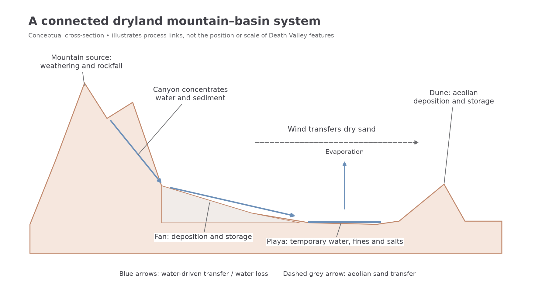
Weathering and rockfalls release debris on mountain slopes. Episodic runoff concentrates in canyons and carries it towards the valley. At canyon mouths, deposition forms alluvial fans; adjoining fans merge into bajadas. Some water and fine sediment reach the low basin floor. In this internally drained setting, evaporation leaves salts on playa surfaces such as Badwater. A playa is a low, usually dry basin-floor surface that may temporarily hold shallow water. A salt crust is a depositional product of the water balance, rather than evidence that the basin never floods.
Sand dried on washes and other deposits becomes available to wind. Local topography traps some of it in dune fields. The NPS 2024 sand-dune account identifies canyon and wash sources and describes crescentic, linear and star forms at Mesquite Flat. Different wind pathways and trapping sites explain why dunes occupy selected parts of a much more varied landscape. Mountains, fans, playa and dunes are linked stores, not separate decorations within a uniformly sandy desert.
[DIAGRAM: asset_name: Connected dryland basin; asset_slug: p18-basin-connections; caption: Water and wind connect mountain sources, fans, playa and dunes.; description: A schematic landscape cross-section, not a map of Death Valley, shows a mountain canyon supplying an alluvial fan, runoff reaching a playa and evaporating, and dry sand transferred by wind to a dune. Arrows distinguish water and sediment movement from wind transport, with labels identifying source, temporary stores and outputs.]
The Namib as a low-latitude desert
The Namib Sand Sea in Namibia is a low-latitude coastal desert where extreme rainfall scarcity coexists with fog and an unusually extensive sand-transfer system.
Near the Tropic of Capricorn, subtropical atmospheric subsidence suppresses rainfall. The cold Benguela Current helps cool the lowest air along the Atlantic coast, promoting stable conditions and fog rather than frequent rain. Fog supplies moisture to organisms without generating the widespread runoff associated with substantial rainfall. Coastal influence therefore modifies the relationship between low latitude, heat and aridity.
UNESCO inscribed the Sand Sea in 2013. Its site assessment identifies a younger active dune system overlying older semi-consolidated dunes, with gravel plains, rocky hills, inselbergs, ephemeral rivers and coastal flats. Gravel-armoured surfaces can supply relatively little loose sand, while sand-rich corridors sustain active dunes. Resistant bedrock hills remain as obstacles around which sand moves and accumulates.
The Namibian nomination dossier submitted for the 2013 inscription explains the long transport chain: erosion inland supplies material to rivers, including the Orange River; ocean currents redistribute coastal sediment; wind moves sand inland and along the coast. Local erosion of the nearest hill cannot explain the entire sand sea. Daily and seasonal changes in effective wind direction also help produce different dune forms, including linear ridges and multidirectional star forms.
Ephemeral rivers, such as the Tsauchab, cross or enter sandy terrain during occasional flows. Flow may lose water through infiltration and evaporation before reaching the sea. Sediment accumulates in channels and low-lying surfaces, while migrating sand can obstruct drainage and separate former channels from their sources. These are interactions between river and dune systems, not evidence that a river must flow continuously through a desert.
Death Valley and the Namib both combine water and wind. Mountain–basin tectonic relief and rain shadow are central to Death Valley, whereas the Namib has a coastal fog setting and a long-distance river–ocean–wind sediment conveyor. Latitude alone explains neither landscape.
Desert landscape change across timescales
The rate of a process and the age of a landform must be distinguished when interpreting dryland change.
Over seconds or minutes, a flood can scour a channel bend, move boulders or breach a small sediment barrier. During the passage of a flood lasting hours, a fan channel may avulse and deposit a new lobe. The NPS record of Hilary in Death Valley on 19–21 August 2023 documents flood-driven reworking of canyons and fans. This event demonstrates rapid modification of existing landforms; their bedrock framework and older deposits pre-date it.
Across seasons, ephemeral streams alternate between active and dry conditions. A canyon may experience its main bed scour during a seasonal flow period and receive rockfall debris during intervening dry months. Rainfall supplies water and fresh sediment; subsequent drying exposes sand to wind. Vegetation may grow following moisture availability and later reduce transport. A survey taken just after a flood and another after a windy dry season may show successive water and wind effects. It would be misleading to extrapolate either short observation into a constant annual rate.
Over millennia, repeated weathering, stream erosion and slope retreat can help develop a pediment, a gently sloping bedrock surface near a mountain front. Older wetter or colder periods may have contributed to its formation. Tectonic changes and shifts in sediment supply further alter the system. Long-term development is the accumulated result of episodes separated by periods of storage, stability or a different climate.
The Namib also operates across these timescales. A brief ephemeral-river flow can scour and redeposit channel sediment, while changing seasonal winds redistribute exposed sand. Repeated transport can build and modify dunes over much longer intervals; older semi-consolidated dunes beneath active sand preserve earlier stages of the system. These relationships imply that the response time of one channel or crest is much shorter than that of the sand sea as a whole.
A persuasive explanation matches evidence to the timescale: repeat photographs show event changes, dated imagery reveals seasonal or decadal movement, and stratigraphy or dated deposits constrain longer histories. A young surface deposit can cover a much older erosional surface. “Age of the landscape” consequently requires a clear statement of what has been dated.
Dawlish as a relict UK dryland landscape
Dawlish in Devon provides a UK example of a former dryland preserved in rock, exposed today in a temperate coastal landscape.
The formation window is the Permian geological period, long before the present landscape and climate. Britain's position within a continental interior differed from its modern setting. Wind deposited sand in dunes; episodic water flows supplied other sediments. Burial and cementation converted these deposits into rock. Subsequent uplift and erosion exposed them in cliffs.
The British Geological Survey's Dawlish Sandstone entry identifies Permian cross-bedded sandstones with beds and lenses of breccia and mudstone, and a type section extending towards Langstone Rock. Cross-bedding consists of inclined layers within a larger sedimentary unit. In a dune interpretation, sand accumulated on successive lee slopes as the dune migrated, preserving inclined layers. Cross-bedding also occurs in water-laid sediment, so its presence alone is insufficient: grain characteristics, scale, geometry and associated deposits help establish the environment.
The Geological Society's Dawlish account interprets wind-blown dune sands and associated alluvial-fan deposits. A breccia contains angular rock fragments. Coarse, angular clasts together with fan sedimentary evidence support rapid transport from nearby relief; this differs from claiming that wind moved the large fragments. The UK evidence therefore links aeolian deposition and episodic water transfer in a former dryland system.
The observation window is modern: twenty-first-century geological descriptions and photographs show exposures of these Permian deposits. Waves, rainfall and slope processes now modify the coastal cliffs. The present cliffs are not active Permian dunes, and modern Dawlish should not be classified as a true dryland. This geological relict complements the two active desert cases; it cannot replace either one's evidence of present desert processes.
Observing and mapping dryland evidence
Reliable dryland investigation separates observations from interpretations and makes comparisons using consistent measurements.
A photograph may directly show a crescent outline, steep lee slope, angular stones or inclined layers. “Barchan”, “debris-flow deposit” and “Permian desert” are interpretations that need supporting evidence. Record scale, viewpoint, date and uncertainty before inferring a process. In sediment work, measure a defined clast axis using a consistent sampling method, rather than selecting only conspicuous large stones. An accessible roadside sample may exclude the fan's less accessible areas.
Geographical information systems allow dated photographs or satellite images to be overlaid in the same coordinate reference system. Georeference them to stable control points, then map dune crests, fan boundaries and channels consistently. Divide measured displacement by elapsed time to calculate a mean migration rate. A mapped fan area must use an appropriate projected coordinate system; changes smaller than image resolution or positional error may not be detectable. Apparent dune movement can also reflect a changed crest shape rather than translation of the whole dune.
Descriptive statistics summarise measurements before testing a relationship. Spearman's rank correlation tests the strength of a monotonic association: whether one variable generally increases or decreases as another increases. Rank both variables in the same direction before subtracting their paired ranks.
Worked example — shelter and crest displacement
Illustrative dataset: five independently surveyed dunes have the annual displacements below. A larger ordered shelter score means more shelter. These are invented observations used to demonstrate the method.
| Independent site | Shelter score | Crest displacement over the same year, m | Shelter rank | Displacement rank | Rank difference, d |
|---|---|---|---|---|---|
| A | 0 | 16 | 1 | 5 | -4 |
| B | 1 | 14 | 2 | 4 | -2 |
| C | 2 | 12 | 3 | 3 | 0 |
| D | 3 | 10 | 4 | 2 | 2 |
| E | 4 | 8 | 5 | 1 | 4 |
For a small sample without tied ranks, Spearman's rank correlation tests the strength of a monotonic association:
Spearman's rank correlation without tied ranks
is the difference between the paired ranks and is the number of pairs. Values near indicate a positive association, values near a negative association, and values near zero little monotonic association. Tied ranks require an appropriate adjusted method.
Each interval is one year, so the mean displacement also corresponds to 12 metres per year. The negative association means greater shelter accompanies less displacement. Under a null hypothesis of no association and independent, exchangeable observations, there are possible rank arrangements. Only two give a perfectly positive or negative correlation, giving a two-sided . It is below 0.05, so reject the null under these assumptions.
Worked example — wind exposure and a longer survey interval
Illustrative dataset: six independent dunes have wind-exposure ranks 1 to 6. Their mapped crest displacements over three years are 12, 18, 24, 30, 48 and 42 metres. The displacement ranks are therefore 1, 2, 3, 4, 6 and 5.
This is a strong positive monotonic association. An exact two-sided permutation test gives , below 0.05. Rejecting no association supports a relationship in these sampled dunes, but does not isolate wind exposure from differences in sand supply, vegetation or dune size.
Statistical significance does not establish cause or guarantee regional representativeness. Five nearby sites on the same dune would not necessarily be independent. Sand supply, dune size and vegetation might also affect movement. Stratified sampling across exposure zones, repeated measurements and reporting measurement uncertainty would make a field conclusion more credible.