3.3 4.c - A changing Arctic Ocean and its governance
The changing Arctic Ocean connects physical feedbacks with livelihoods, trade and international relations. This lesson explains sea-ice evidence and thresholds, distinguishes maritime rights from ownership claims, and examines how Indigenous peoples, shipping interests and governments respond to a changing environment.
Sea ice, warming and thresholds
Sea ice is frozen seawater that expands and retreats seasonally, unlike an ice sheet resting on land. Its extent is commonly measured as the total area of ocean grid cells containing at least 15% ice cover. Extent is not the area of solid ice within those cells, and neither measure alone reveals thickness or volume.
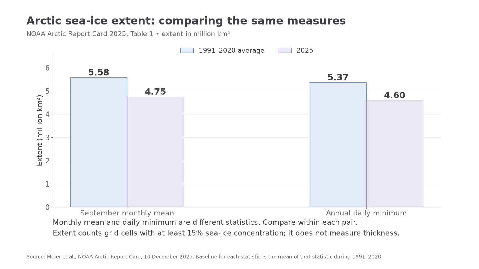
The NOAA Arctic Report Card 2025 reports September's monthly mean extent as million square kilometres, compared with a 1991–2020 September mean of . The 2025 daily minimum was , compared with a 1991–2020 mean of annual daily minima of . Monthly means and daily extremes are different statistics. The report describes a younger, thinner and less extensive ice cover over recent decades, although 2025's minimum was not the lowest in the satellite record. A long-term decline can contain individual years of higher extent.
Worked example — monthly-mean extent
Compare September monthly means using the NOAA values above.
Worked example — annual daily minima
Now compare annual daily minima with their corresponding baseline.
These results answer different questions. Mixing the daily minimum with the monthly-mean baseline would compare different statistical measures.
[DIAGRAM: asset_name: Arctic sea-ice measures in 2025; asset_slug: d22-arctic-extent; caption: September monthly means and annual daily minima are compared separately with their 1991–2020 baselines; description: Two groups of bars show monthly mean extent of 5.58 million square kilometres in the 1991–2020 baseline and 4.75 in 2025, and annual daily minimum extent of 5.37 and 4.60 respectively. The chart distinguishes the two measures and identifies NOAA Arctic Report Card 2025 as the source.]
Sea-ice loss can reinforce warming through the ice–albedo feedback. Albedo is the proportion of incoming sunlight reflected by a surface. Bright ice and snow generally reflect more sunlight than dark open water. Initial warming melts some ice; exposed water absorbs more incoming solar energy, warming the ocean and encouraging further melting or delayed autumn freezing. This is a positive feedback because it amplifies the initial change, not because its consequences are beneficial. Seasonal sunlight, clouds, ocean heat transport and weather also influence the response.
A threshold is a level beyond which a system's behaviour changes substantially. Some systems exhibit hysteresis: reversing the original forcing may not immediately restore the earlier state. However, the existence of a positive feedback does not prove an irreversible tipping point. The IPCC's 2021 assessment finds no critical global temperature threshold beyond which summer Arctic sea-ice loss necessarily becomes self-accelerating and irreversible. Ice can potentially regrow if conditions cool. This does not promise rapid recovery of every affected ecosystem, coastline or livelihood, and does not make continued warming harmless. Investigate evidence for each proposed threshold rather than assuming all environmental changes have identical reversibility.
Arctic geopolitical change
Geopolitics concerns relationships between geographical space, resources and political power. Reduced sea ice can make areas more accessible and increase the perceived value of routes and resources. States may consequently invest in ports, surveillance, research and military capacity, while disagreeing over navigation or maritime rights. Accessibility can intensify an existing disagreement without creating a new legal entitlement.
The Arctic is surrounded by established states and maritime zones. Russia, Canada, the United States through Alaska, Norway, and the Kingdom of Denmark through Greenland have Arctic Ocean coasts. Their territorial seas and exclusive economic zones are governed by the relevant law of the sea; melting ice does not turn these into unowned water. Conversely, an exclusive economic zone grants resource and specified jurisdictional rights rather than complete sovereignty over every ship passing through it.
The continental shelf creates a further distinction. Under UNCLOS, coastal states can establish rights over the seabed and subsoil of a continental shelf, in some circumstances beyond 200 nautical miles. Those rights do not convert the overlying high-seas water into national territory. An ice-free surface and a submarine ridge are therefore relevant to different geographical and legal questions.
The UN Commission on the Limits of the Continental Shelf's submission register records Arctic submissions. For example, Russia's Gakkel Ridge submission, first made in 2023, has an amended executive summary dated March 2026. This is evidence of an ongoing process concerning outer continental-shelf limits, not proof that one state owns the entire Arctic Ocean. The commission considers scientific and technical evidence for outer limits; it does not settle all overlapping boundaries or land-sovereignty disputes.
Competing priorities can include resource income, national security, freedom of navigation and environmental protection. Non-Arctic states may have trade and scientific interests without acquiring sovereign rights merely by sending ships. Geopolitical analysis should identify the specific place, type of right, actor and mechanism of influence, rather than describing the region as a single unrestricted race to claim a melting ocean.
Continue this lesson.
You’re previewing NovaLearn without an account. Create a free account to read the rest.
Create free account