3.3 5.a, 5.b - Ocean trade, naval influence and territorial conflict
Oceans connect producers and consumers while also concentrating strategic interests. This lesson explains major shipping routes and cargo flows, shows how the United States uses a network of naval locations, and examines the South China Sea as a conflict involving resources, territory, maritime rights and international law.
Principal shipping routes and vessel scale
Ocean transport moves goods between ports, where sea routes connect with roads, railways, pipelines and inland waterways. Routes concentrate where large production and consumption centres generate demand and where geography permits economical passage. The UNCTAD Review of Maritime Transport 2025 identifies shipping's central role in international goods trade. Its approximate 80% share concerns trade in goods by volume, not 80% of services or of the monetary value of all world trade.
Principal networks include the North Atlantic, linking eastern North America with western Europe; the North Pacific, linking East Asia with North America's Pacific coast; and the Asia–Europe route, commonly passing through the Strait of Malacca, Indian Ocean, Bab el-Mandeb, Red Sea and Suez Canal before reaching the Mediterranean and Europe. The Panama Canal connects Atlantic and Pacific networks. The Strait of Hormuz connects the Persian Gulf with the Arabian Sea, making it important to energy movements. Routes around the Cape of Good Hope provide an alternative to Suez for suitable journeys, usually with a longer distance between Asia and Europe.
[DIAGRAM: asset_name: Ocean routes and United States naval locations; asset_slug: d23-routes-naval; caption: Selected principal routes, chokepoints and United States naval locations connect trade geography with strategic reach; description: A world map labels schematic North Atlantic, North Pacific and Asia–Europe connections, and the Suez Canal, Panama Canal, Strait of Malacca and Strait of Hormuz. Separate location symbols identify Norfolk, San Diego, Pearl Harbor, Yokosuka and Bahrain. Route lines do not represent measured traffic volumes or territorial boundaries.]
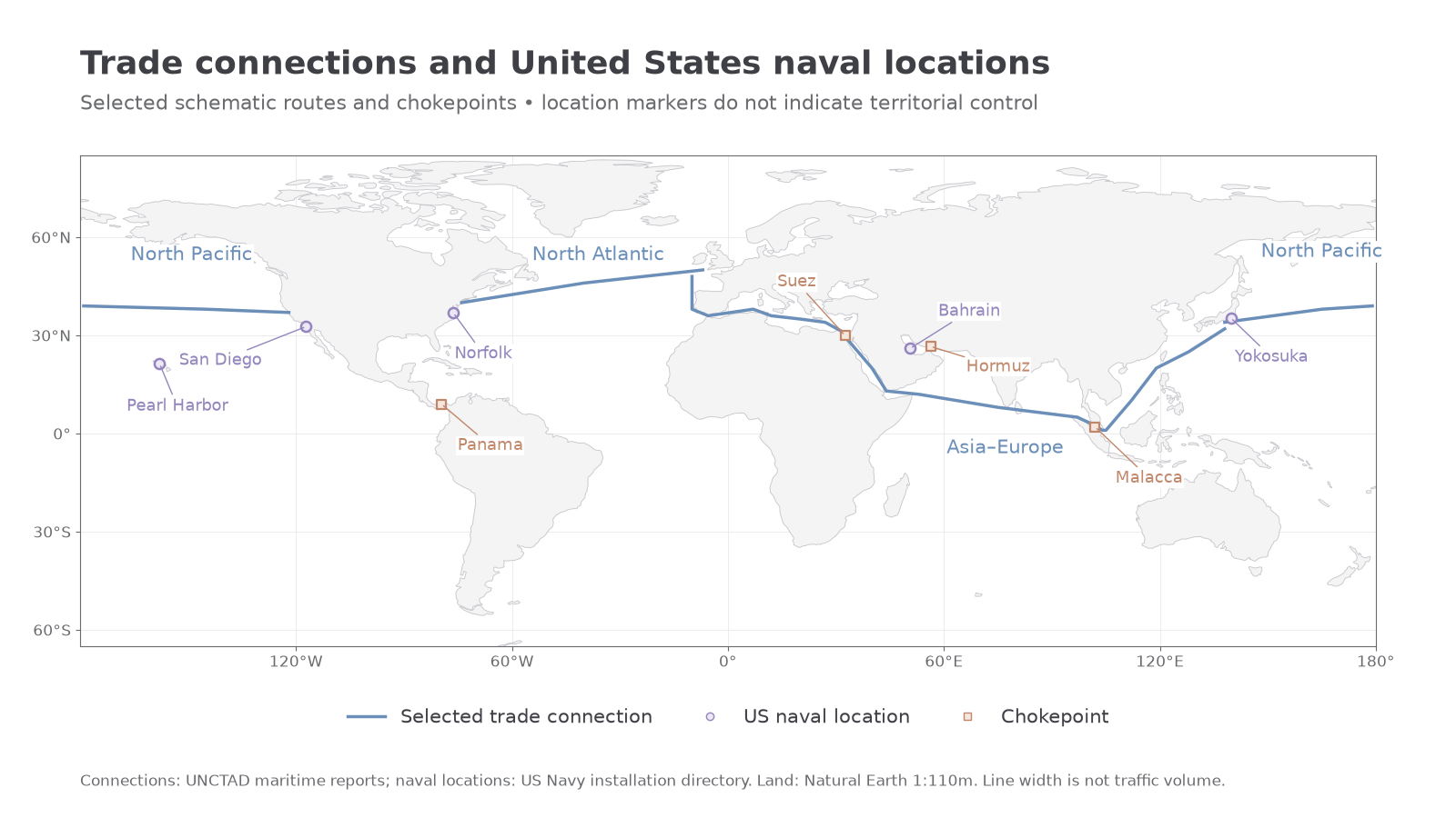
A chokepoint is a narrow or otherwise constrained passage through which important flows concentrate. Its value comes from the networks depending on it: a blockage or security threat can disrupt destinations far away. UNCTAD's 2024 report examines the effects of Red Sea insecurity and Panama Canal constraints on shipping and rerouting in that period. These dated disruptions illustrate vulnerability; their precise conditions should not be assumed to remain unchanged in every later year.
Larger vessels can spread crew, fuel and capital costs over more cargo when well loaded. Container standardisation also supports transfer between ship, rail and road without unpacking individual goods. However, larger ships require sufficient depth, turning space, cranes and landside capacity. Draft, width and length can restrict canal or port access. Dredging and expanded terminals can be costly and environmentally damaging. Concentrating cargo on fewer large ships may lower unit costs while making a single disrupted sailing more consequential. The economically preferred route therefore depends on vessel size, load, infrastructure, reliability and risk as well as distance.
Directions and types of ocean trade
Ocean trade is differentiated by cargo, direction and the economic relationships linking places. A bulk carrier transports unpackaged dry cargo such as iron ore or grain; tankers transport liquids such as crude oil and petroleum products. Specialised ships can carry liquefied gases. Container ships move standardised units containing many manufactured and intermediate goods. These systems require different vessels, terminals and handling facilities.
Broad patterns reflect the separation of resources, processing and consumers. Iron ore from Australia and Brazil supplies industrial markets including East Asia. Energy exports from the Persian Gulf move to major importing regions, particularly Asian markets, while other suppliers and routes also matter. East Asian manufacturing centres send containerised products towards Europe and North America, but return movements include inputs, agricultural products, manufactured goods and sometimes empty containers. Grain moves from exporting regions such as the Americas and Australia to food-importing markets. These are examples of major connections, not statements that every commodity moves only in one direction. UNCTAD's 2024 maritime assessment distinguishes these cargo sectors and their changing demand.
Production networks can involve several sea journeys before a finished product reaches a consumer. A mineral may move to a processing country, a component to an assembly plant, and the finished product to another market. Shipping therefore helps create interdependence: production in one place depends on supplies and transport services elsewhere. This connects ocean geography with globalisation, resource use and development.
Trade volumes alone do not show the distribution of benefits. A port can gain handling income and employment while nearby residents experience noise, pollution or displacement. A raw-material exporter may remain vulnerable to changes in commodity prices even when export tonnage is large. Import-dependent regions can face higher costs if a distant chokepoint is disrupted. Analyse the commodity, route, actors and scale before judging whether ocean trade produces development or vulnerability.
United States naval strongholds
Naval influence depends on the ability to support ships and personnel across distance, rather than simply owning a large fleet. Ports and bases can provide maintenance, supplies, communications, training and access to nearby sea routes. Their strategic importance depends on location, facilities, political agreements and the missions they support.
The United States provides a useful case because it has major domestic naval locations facing different ocean areas and overseas facilities supporting operations farther away. The US Navy installation directory identifies Norfolk on the Atlantic coast of Virginia, San Diego on California's Pacific coast and Pearl Harbor in Hawaii in the central Pacific. Norfolk provides access towards the North Atlantic; San Diego towards the eastern Pacific; Hawaii supports reach across the Pacific's large distances. These are complementary geographical positions rather than interchangeable dots on a map.
Continue this lesson.
You’re previewing NovaLearn without an account. Create a free account to read the rest.
Create free account