1.1.2 - Water development in a glaciated landscape
Human activity can transform a glaciated valley long after its glacier has disappeared. This lesson uses Haweswater and the surrounding managed Lake District landscape to explain water-supply development, changed flows, sediment trapping and valley-floor change. It also uses Swindale Beck restoration to evaluate how later management can reconnect water and sediment processes.
Water supply in the Haweswater landscape
Haweswater occupies Mardale in the eastern Lake District, north-west England. Its mountain valley and lake setting belong to a relict glaciated landscape: earlier ice shaped the broad valley, while modern rainfall, streams, slopes and management now supply the active processes. The water-supply scheme does not interrupt a present-day local glacier.
Reservoir development raised water within the existing valley and inundated land around the former lake. Historic England's archive records the Mardale landscape before flooding in 1935 and identifies water supply to Manchester as the purpose. Historic England, Goosemire Farmstead record, 2 March 1935. This is evidence of a direct change to the valley floor and human use, rather than a new valley excavated by the dam.
The location offered a catchment with substantial upland runoff and a valley form suitable for impounding water. Demand arose from people and economic activity beyond the local mountain landscape. Storing and transferring water connects the uplands with urban consumers: the motive is water supply, while the geomorphic effects follow from the structures and altered flows needed to deliver it.
United Utilities' December 2024 account states that Haweswater served more than two million people in the Manchester-area supply context. The dated claim shows the scale of the system without assuming the same operational share in every subsequent year. United Utilities, 2 December 2024.
The wider managed Haweswater estate includes neighbouring valleys such as Swindale, as well as the reservoir itself. Management boundaries and engineered water routes are not identical to natural drainage boundaries. Swindale Beck naturally belongs to the Eden river system; it should not simply be drawn as a natural stream entering Haweswater. Swindale restoration project record. Distinguishing these boundaries keeps the case geographically accurate.
Dams, channels and sediment transfers
Water-supply infrastructure changes both the amount of material moving through a landscape and the pathways it follows. A dam impounds water, converting part of an active channel and valley floor into a larger surface-water store. Intakes and diversions can transfer runoff towards a reservoir, while abstraction removes water for use elsewhere.
Flow generally slows as a sediment-bearing stream enters an impoundment. Coarser material can settle where transport capacity falls, while finer material travels farther before deposition or remains suspended. The reservoir therefore interrupts sediment connectivity. Trapping is not necessarily complete: particle size, floods, water level and operation determine what passes through.
Intakes and weirs create smaller interruptions. Gravel and grit can build up near a structure, affecting the movement of water as well as sediment. Removing accumulated material then changes the store and its connection with downstream channels. United Utilities reported removing 862 tonnes across six sites around Haweswater in 2024 to maintain flows and sediment movement. That is an operational sediment-removal total, not a measured annual bedrock-erosion rate or the volume of the whole reservoir's sediment.
[DIAGRAM: asset_name: Dam and sediment connectivity; asset_slug: p14-dam-sediment; caption: An impoundment creates storage and alters the water and sediment delivered downstream; description: A schematic longitudinal section shows a stream entering a reservoir, sediment accumulating where flow slows, a dam and controlled downstream release. An abstraction route is shown separately. Labels distinguish storage, incoming sediment, trapped sediment and downstream supply. The geometry explains a mechanism and is not a surveyed Haweswater profile.]
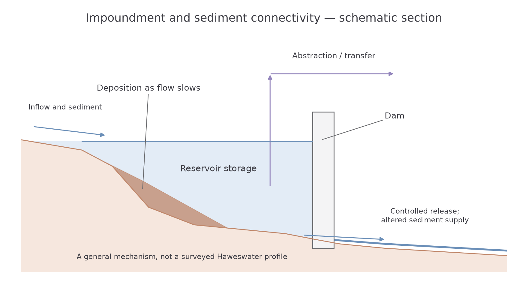
Downstream effects depend on both sediment supply and transport energy. Water released with little sediment can erode a channel if it still has sufficient power and erodible material is available. Conversely, reduced flood peaks or lower discharge may reduce transport capacity. A dam therefore does not automatically cause the same amount of scour everywhere. An explanation must compare changes in water, sediment and boundary conditions.
In a relict glacial landscape, the immediate active agent is often flowing water rather than ice. Nevertheless, modification of sediment inherited from glaciation and of a glacial valley's floor changes the glaciated landscape system. Its geological origin and present operating processes are different parts of the explanation.
Changing valley-floor landforms
Human changes become landscape changes when altered flows or storage modify the form and arrangement of the valley's landforms. At Haweswater, raising the water level extended the inundated area across part of the valley floor. Channels, deposits and former land surfaces beneath the reservoir were placed within a new lake-margin and submerged environment.
The direct transformation is clear in the historical record: land used by the Mardale community became part of a water-storage landscape. The resulting shoreline follows the inherited valley geometry but stands at an engineered level. Operation can then expose or submerge different margin surfaces as storage changes. The dam has changed the boundary conditions through which water acts, while the broader glacial valley remains recognisable.
Upstream, accumulated sediment can alter bed levels and flow paths around structures. The 2024 maintenance evidence demonstrates real sediment storage at intakes and weirs, followed by deliberate removal. It does not establish a particular long-term downstream incision depth, which would require channel surveys. This distinction avoids substituting a generic dam-impact diagram for measured case evidence.
The neighbouring Swindale valley provides a documented channel response to another human intervention. Historical straightening and bank raising sought to increase usable farmland and move water rapidly through the valley. Natural England's 2016 account describes channel gravel accumulation, bank problems and altered flooding before restoration. Natural England, 13 October 2016. These are changes to an active river corridor within the managed glaciated landscape, rather than new glacial erosion.
Together the examples show several scales of consequence: a sediment obstruction at an intake, a modified channel through a valley floor and an enlarged water body occupying a glacial basin. Their significance differs, but all can be traced back through changed water, energy or sediment transfers. A broad claim that “humans damage the landscape” lacks these testable links.
Worked resource application — human influence on a channel
Illustrative resource: a valley-floor plan shows a straightened river confined between raised banks. A second plan shows the banks removed and several bends reinstated. Referring to the plans, suggest how the intervention could influence river processes. Removing the raised banks allows high water to leave the channel and spread across the floodplain. That lowers local velocity and creates opportunities for temporary water storage and deposition. Reinstated bends also redistribute flow energy between inner and outer banks, promoting a more varied arrangement of erosion and sediment accumulation. The suggestion uses the structures shown in the resource to explain physical transfers, rather than assuming that the word “restoration” proves every intended benefit.
Restoration and system evidence
Restoration can alter the same process connections that earlier engineering changed, but it should be assessed through measured outcomes rather than its label. Swindale Beck's 2016 project replaced a straightened reach with a more sinuous channel and removed raised banks, allowing greater interaction with adjacent meadows.
A longer channel route spreads a given valley-height drop over more distance, reducing average channel gradient. Bends introduce spatial contrasts in velocity and encourage pools, riffles and gravel deposits. Lower banks allow high water to spread onto the floodplain, temporarily storing water and some sediment before it returns to the channel. These mechanisms alter both the timing of flow and the arrangement of valley-floor landforms.
The RSPB's restoration account reports the development of pools, riffles and gravel banks after the 2016 works. This supplies an observed landform response alongside the intended water-management benefits. RSPB, Swindale Beck: a river restored, checked 14 October 2026. The intervention did not return the entire estate to a pre-human condition; it changed specific channel constraints within a continuing managed landscape.
To evaluate the outcome, compare dated channel surveys, bed-material observations and floodplain inundation records before and after intervention. Similar flow events provide a better comparison than contrasting an ordinary summer day with an exceptional winter flood. A nearby comparison reach can help separate the intervention from wider climatic variation. Statements about reduced risk downstream require evidence at the relevant scale, not simply a photograph of a new bend.
There are also trade-offs. More local floodplain storage deliberately allows some land to flood, while maintaining water supply may still require intakes, dams and sediment maintenance elsewhere. The case shows that different human objectives can change the same system in different ways. Its strongest evaluation traces the actual transfers and landform responses, then judges how well they serve the stated purpose.
Worked argument — human and physical influences on landscape change
Assess the relative importance of human activities and physical processes in changing a glaciated landscape. In the Haweswater estate and neighbouring managed valleys, human decisions strongly control the timing and location of recent changes, while inherited relief and continuing river processes determine their form and persistence. Importance therefore depends on whether the focus is the origin of the valley or its contemporary water and sediment system.
Physical processes explain the broad landscape that made development possible. Earlier glacial erosion produced the valley and basin, while upland precipitation supplies the runoff now stored and transferred. A dam does not excavate the whole trough, and development in this relict landscape does not restart glacial erosion. At the scale of the valley's underlying geometry, ice and geology remain fundamental. However, explaining that inheritance alone would leave the twentieth-century transformation of the valley floor unexplained.
Human water-supply demand was decisive for that more recent transformation. Historic England's 2 March 1935 Mardale record documents land before inundation for Manchester's supply. Raising the reservoir level placed former land surfaces and channels within a new water body, creating an engineered shoreline. The scale of the continuing connection is indicated by United Utilities' December 2024 account that Haweswater served more than two million people. A distant urban demand therefore helped determine which upland surfaces were submerged and which transfers were maintained. That is stronger evidence of direct human control than a general association between population growth and landscape change.
The resulting sediment response still operates through physical mechanisms. Water slows in an impoundment, allowing some material to settle; downstream changes depend on the relationship between released water, sediment supply and erodible deposits. The 862 tonnes removed across six sites in 2024 demonstrate that management encounters real sediment accumulation around structures. They do not measure an equivalent amount of new bedrock erosion. Human operation changes connectivity, while floods, particle properties and available energy determine how material moves within those constraints.
Swindale Beck shows a different human objective producing another system response. In 2016, Natural England, the Environment Agency, RSPB and United Utilities restored bends and removed raised banks. Lengthening the flow path reduced its average gradient; renewed lateral connectivity allowed high water to spread into meadows. The RSPB's subsequent account reports pools, riffles and gravel banks. This supports a judgement that intervention can enable a more varied channel rather than merely impose a fixed shape. Its extent is narrower than reservoir inundation: it changes a river corridor within the valley, and the outcome remains sensitive to subsequent floods and maintenance.
Overall, physical processes dominate the explanation of the glacial valley's origin and supply the mechanisms of continuing adjustment. Human decisions have greater immediate importance for the location, level and connectivity of recent managed water bodies and channels. The most convincing assessment treats them as interacting controls: intervention sets new boundary conditions, then water and sediment respond through physical processes whose outcomes need dated monitoring. Neither the persistence of the trough nor the announcement of restoration alone establishes which influence dominates every scale of change.