1.1.1 - Coastal deposition and sediment landforms
Coastal deposition occurs where sediment supply, transport and local energy allow material to accumulate. This lesson explains beaches, spits, on-shore bars, tombolos and salt marshes, including the links between their shape and the processes building them. You will also learn why a depositional landform can migrate or erode while remaining part of an active sediment system.
Sediment transport and deposition
Deposition is the settling or accumulation of transported sediment when the transporting flow can no longer keep it moving or when an obstacle traps it. Sediment must first be available: a sheltered bay without a supply cannot develop a large beach simply because its waves are weak.
Moving water carries dissolved material in solution and fine particles in suspension. Sand and small pebbles may bounce along the bed by saltation, while larger particles roll or slide by traction. The required force generally increases with particle size, although cohesive clay behaves differently from loose sand. Fine sediment can stay suspended after coarser material settles. In sheltered brackish water, fine particles can combine into larger aggregates, helping mud deposition.
Longshore drift occurs when breaking waves approach the shore obliquely. Swash moves sediment up the beach at an angle, while gravity directs backwash downslope. Repetition produces net alongshore movement. Wave-driven longshore currents also transport sediment in the surf zone. Changing wave direction can reverse transport for a time; net drift describes the balance over a stated interval, not every movement of every grain.
Cross-shore transfers redistribute sediment between beach and offshore bars. Storm waves can remove material from the upper beach, while calmer conditions may return some of it onshore. River deposition supplies material at mouths, and wind can remove dry beach sand into dunes or return it from exposed land. Whether a store grows depends on its complete budget, including transfers invisible during one site visit.
A useful explanation therefore joins three questions: where did the sediment originate, what moved it, and why did it accumulate here? Reduced wave energy, a change in coastline direction, a sheltered lee or vegetation trapping may supply the final link. Deposition does not mean that the landform has stopped changing.
Beaches and their changing profiles
A beach is an accumulation of sediment along the shore, repeatedly reworked by waves and tides. It may contain sand, shingle or a mixture. Its profile is a cross-section from the backshore towards the sea; changes in slope, ridges and sediment levels reveal how the store is distributed.
Low-steepness waves often transport sediment towards the upper shore and can build a berm, a ridge near the upper limit of ordinary swash. During energetic storms, material may move down the profile into bars, leaving a lower or flatter upper beach. Recovery requires an available offshore store and suitable subsequent waves. Permanent export to deeper water cannot be assumed to return next summer.
Sediment size affects the response. Shingle is relatively permeable, so water can infiltrate during swash and reduce the volume returning as backwash. This can help maintain a comparatively steep profile. Finer sand commonly produces gentler slopes because it is less permeable and more readily moved. Sorting and mixed grain sizes complicate this tendency: a profile cannot be predicted from one pebble or one average size alone.
A sequence of surveys is stronger evidence than a single profile. If a winter survey shows the beach lower than in summer, compare tides, storm history and the offshore store before attributing the entire difference to season. An eroding beach section may be transferring sediment to another section rather than losing it from the whole cell.
Spits, on-shore bars and tombolos
A spit is an elongated ridge of deposited sediment attached to land at one end. It commonly begins where longshore transport reaches a change in coastline direction, such as the entrance to a bay or estuary. Sediment continues into the more sheltered water, transport capacity declines and a ridge extends beyond the original shoreline.
Its growth requires continuing supply. Waves approaching from different directions, refraction around the end and tidal currents can curve or rework its distal end. A recurved end therefore records changing transport conditions; it is not evidence that one prevailing wind always blows the sand backwards. Strong river or tidal flow may keep an inlet open and prevent the spit crossing it completely. Behind the ridge, reduced wave energy can allow fine sediment and salt marsh to accumulate.
A bar is an elongated sediment ridge. An on-shore or bay-mouth bar lies at the shore and may extend across a bay, joining land at both ends and enclosing a lagoon. Alongshore transport can extend a spit until it reaches the opposite side where through-flow is insufficient to maintain the opening. This should be distinguished from a submerged offshore bar built by cross-shore transfer. The term describes form and position; the particular formation mechanism still needs explaining.
A tombolo connects the mainland to an island. Waves refract and diffract around the island, creating a lower-energy area in its lee. Where suitable sediment is available, transport convergence and deposition can build a connecting ridge. If currents remain too strong or the island is too far from shore, no permanent connection develops.
[DIAGRAM: asset_name: Spit, bay-mouth bar and tombolo; asset_slug: p03-depositional-planforms; caption: Sediment supply and local shelter produce different depositional connections; description: Three separate schematic plan views show a recurved spit attached at one end with an open inlet, a bay-mouth bar attached at both ends with a lagoon behind, and a tombolo linking a mainland to an island. Arrows indicate sediment drift or wave approach. The shapes are explanatory and not maps of named places.]
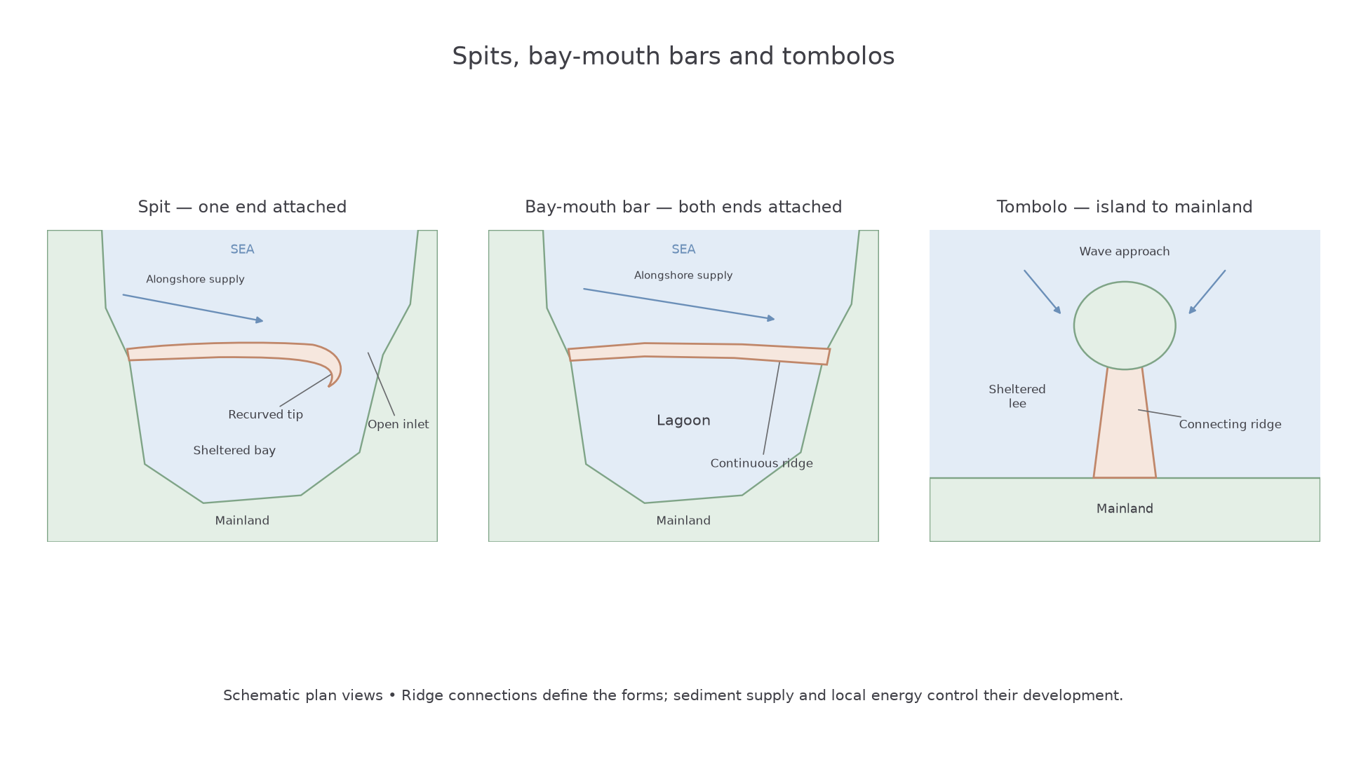
These landforms can migrate. Storm overtopping transfers sediment landwards, and changing supply can erode the connection while deposition continues elsewhere. Their persistence depends on the balance among supply, accommodation space and transport, rather than on deposition happening once.
Salt marsh development
Salt marsh develops where fine sediment can accumulate on an intertidal surface and salt-tolerant vegetation can establish. Sheltered estuaries and the lee of spits provide suitable low-wave-energy settings, although tidal currents remain important for supplying water and sediment.
At slack water, when tidal flow slows around its reversal, suspended particles can settle. Repeated deposition raises a mudflat. Once the surface has sufficient exposure between tides, pioneer plants can colonise. Their stems slow near-surface flow and their roots bind sediment, reducing its remobilisation. This encourages further accumulation and plant growth: a positive feedback that helps stabilise and elevate the surface.
As height increases, inundation becomes less frequent and different plants can establish. Small differences in elevation, drainage and salinity produce a mosaic of communities rather than a perfectly uniform succession. Tidal creeks deliver sediment into the marsh and drain it as the tide falls. The marsh, mudflat and channels are connected parts of the same system.
Vegetation does not guarantee permanent growth. A marsh can keep pace with rising relative sea level only if mineral sediment deposition and organic accumulation compensate sufficiently for water-level rise and subsidence. Wave attack at its edge, reduced sediment supply or obstruction of landward migration may cause loss. A sea wall can protect land while preventing the marsh retreating inland, creating coastal squeeze.
At Medmerry in West Sussex, managed realignment was completed in November 2013. Breaching the former defence allowed tides into a deliberately set-back area, creating 183 hectares of intertidal habitat, according to the Environment Agency's 2014 project account. Opening land to tides creates space for mudflat and salt-marsh development; it does not mean all 183 hectares instantly became mature salt marsh. Sediment supply, surface elevation and vegetation succession govern how the habitat develops.