1.1.2 - Post-glacial climate and meltwater landforms
A warming climate changes the balance between ice movement and meltwater activity. This lesson explains how deglaciation can produce kames, eskers and outwash plains, and why their sediments differ from direct glacial deposits. It also examines how rivers, vegetation and future climatic change can modify these inherited landforms.
Deglaciation and changing processes
Deglaciation is the reduction or disappearance of ice from an area, often associated with sustained negative glacier mass balance. Warming raises the energy available for melt and can shift precipitation from snow towards rain. If accumulation no longer compensates for losses, ice thins and its margin commonly retreats.
The transition from the last glacial period towards the Holocene provides the major inherited setting for many British meltwater landforms. Local retreat did not happen everywhere at once or without interruptions. A climate fluctuation, a changing snow supply or different glacier geometry could slow retreat or cause a readvance. “Post-glacial” describes a location after its ice has gone, rather than a claim that no glaciers remain anywhere on Earth.
As the ice shrinks, its ability to move and supply debris changes. Water released by melting gains importance as a transport agent. Streams flow on, within and beneath the ice, sometimes under pressure, before emerging at the margin. They can erode sediment stores as well as carry newly released debris. Ice blocks left in the forefield can temporarily support or obstruct deposits and channels.
Glacio-fluvial landforms are produced by meltwater associated with glaciers. Water sorts sediment according to flow strength and particle properties, commonly creating layers of sand and gravel. Directly deposited till is typically much less sorted. However, mixtures and reworking occur: a river can cut through till and redeposit selected particles downstream.
A warming transition can therefore change both the transporting agent and the position of deposition. Ice-contact deposits form beside or within decaying ice, while proglacial deposits accumulate beyond its margin. The sequence depends on the available sediment and discharge, not temperature alone. If an ice body has largely disappeared, its later meltwater contribution must eventually decline.
Kames and eskers
Kames and eskers preserve deposits formed in close contact with glacier ice, but their different shapes reflect different depositional environments. Both commonly contain sorted or stratified sediment because water, rather than direct ice release alone, did much of the deposition.
A kame is an irregular mound of sand and gravel associated with deposition against, on or within decaying ice. Meltwater can deposit sediment in a depression or pond held by ice when velocity falls. After the supporting ice melts, the deposit remains as a mound, often modified by collapse and slumping. Where sediment accumulates along a valley side between land and ice, removal of the ice can leave a kame terrace. Its bench-like form records the former ice-contact setting.
An esker is a long, often sinuous ridge of sand and gravel deposited by a meltwater stream flowing through an ice-walled channel, commonly beneath or within a glacier. When discharge or transport capacity falls, the channel becomes partly filled with sediment. The surrounding ice later disappears, leaving the fill standing as a ridge above the adjacent ground.
This explains an apparent inversion: a former low route through the ice is preserved as a high feature after its walls melt. A stream beneath thick ice can also be driven by water-pressure gradients, so an esker need not follow the downhill surface route that a modern unconfined river would take. The BGS esker definition, checked 14 October 2026, identifies the sinuous, stratified ice-channel deposit.
[DIAGRAM: asset_name: Ice-contact deposition and inherited ridges; asset_slug: p12-meltwater-landforms; caption: A mound from an ice-contact deposit and a ridge from a meltwater channel remain after the supporting ice disappears; description: Two schematic stages show an ice margin with a sediment-filled subglacial channel, an ice-contact sediment mound and a braided outwash area. After melting, the channel fill is an esker, the mound is a kame and the outwash plain remains beyond them. Shapes indicate depositional environments, not a measured landscape.]
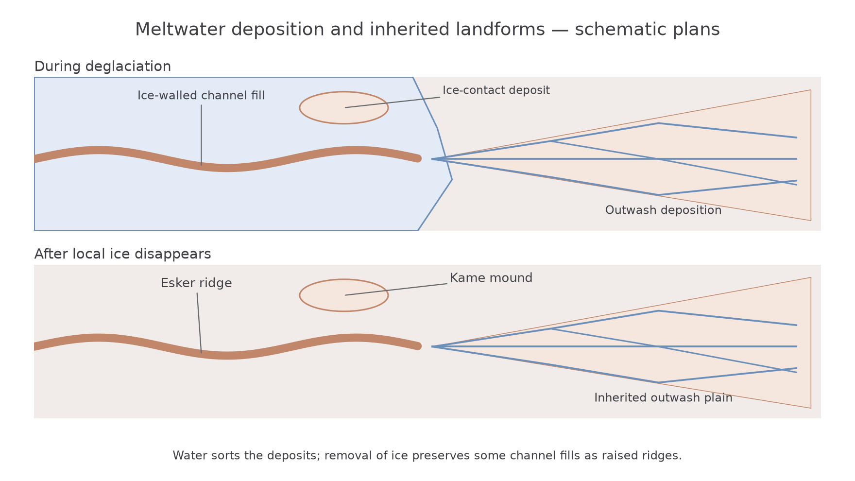
A ridge should not be called an esker solely because it curves. A moraine can also form a ridge but commonly contains less sorted material and has a different relationship to the former margin. Sediment structure, grain sizes and regional landform arrangement help discriminate between explanations. BGS's north-east Scotland account describes examples including the Kippet Hills, demonstrating how mapped forms and sediments are used together. BGS glacial and glacio-fluvial landforms, 2003 regional account.
Outwash plains
An outwash plain is a broad accumulation of sediment deposited by meltwater beyond a glacier margin. Its form reflects the interaction of high sediment supply, variable discharge and a surface across which channels can shift.
Meltwater emerges carrying material released by ice or eroded from the bed and margin. As water spreads, the channel gradient or confinement may decrease and its capacity to transport coarse particles falls. Sand and gravel accumulate in bars and sheets. Flow divides around deposits, creating multiple channels that separate and rejoin: a braided pattern.
Braiding is encouraged by abundant mobile sediment, variable flow and relatively unstable banks. During a melt peak or flood, channels can widen, shift and erode earlier deposits. As discharge declines, bars become exposed and finer material can settle. The plain therefore builds through alternating deposition and erosion; it is not simply a flat pile dumped during one instant of glacier retreat.
Sorting commonly produces coarser material nearer high-energy supply routes and finer sediment farther away, but local channel migration complicates the pattern. A sample from one bar cannot establish the grain size of the whole plain. Layers can record successive flow conditions, while abandoned channels show that the transport network has moved.
At an active ice margin such as west Greenland's Kangerlussuaq sector, sediment supply and discharge continue linking the ice with the proglacial river and downstream stores. In a British relict landscape, the glacier-fed discharge has ceased, but later rivers can occupy or incise an inherited outwash surface. Similar present forms can therefore have different balances between ongoing construction and subsequent modification.
Present and future modification
Meltwater landforms continue changing after deposition, and climate influences which modifying processes dominate. An esker or kame can be cut by a later river, weathered at the surface or modified by slope failure. Vegetation and soil development may stabilise sediment locally, while removal of supporting buried ice can cause subsidence and collapse.
Outwash plains respond to changes in both discharge and sediment supply. A flood can erode bars and cut a new channel, whereas declining flow can leave deposits inactive and allow vegetation to establish. If river transport capacity increases relative to supply, incision can lower the active channel below an older depositional surface, leaving a terrace. A greater discharge does not guarantee net deposition.
Future warming can initially increase meltwater from some glaciers, but continued ice loss reduces the remaining store. A catchment may pass a period of maximum glacier-derived runoff, often called peak water, followed by decline. Its timing varies with glacier size, climate and basin geometry. Rainfall changes can partly compensate or intensify the effects, so total river discharge and glacier melt contribution are not interchangeable. IPCC AR6 Working Group II, Water, 2022 assesses these contrasting runoff responses.
Changing meltwater availability can alter braiding, sediment connectivity and the erosion of kames or eskers. More exposed forefield may also supply loose debris for a time, while stabilisation can reduce later supply. The response is therefore a sequence, not a permanent rule that warming always increases every flow or erosion rate.
For a relict British outwash plain, future climate acts mainly through rainfall, rivers, weathering and vegetation rather than renewed local glacier melt. A precise explanation identifies whether ice is still present, what material is available and which process can reach the landform. That connects past formation with current and future modification without confusing their climates.