3.5 1.b - Plate boundaries, processes and crustal features
Relative plate movement produces distinctive combinations of landforms, earthquakes and volcanism. This lesson locates the main plate system and explains divergence, three convergent settings and conservative boundaries, connecting each process with its surface and depth patterns.
Global plates and divergent boundaries
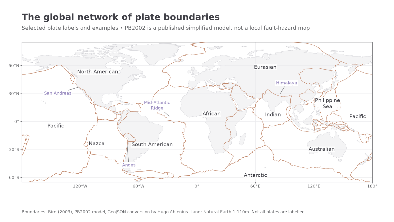
Plate boundaries form a connected global network, although some are broad deformation belts rather than one narrow line. The Pacific Plate occupies much of the Pacific basin; North American, South American, African, Eurasian, Antarctic and Indo-Australian regions occupy large parts of the remaining surface. More detailed models distinguish Indian and Australian plates and many smaller plates, including Nazca and Philippine Sea. A continent is not synonymous with a plate: plates commonly contain both ocean and land.
The Mid-Atlantic Ridge separates North American from Eurasian regions in the north and South American from African regions farther south. Convergent margins surround much of the Pacific, while the Alpine–Himalayan belt crosses southern Eurasia. Transform segments connect many ridge sections. The USGS global plate map places these boundaries in their geographical context.
The map uses Bird's published 2003 PB2002 model, a simplified representation of a more complex deforming Earth. Its boundary lines must not be read as exact local hazard-zone edges.
[DIAGRAM: asset_name: Global plate-boundary setting; asset_slug: d34-global-plates; caption: Mapped plate boundaries and selected plate labels show the global network and examples used in this lesson; description: A world map plots the Bird 2003 PB2002 boundary dataset with selected major plate names and labels for the Mid-Atlantic Ridge, Andes, Himalaya and San Andreas region. Boundary traces are a simplified published model, not exact local hazard zones or coastlines.]
At a divergent, or constructive, boundary, plates move apart. Mantle rises and pressure decreases, permitting partial melting without requiring a new source of frictional heating. Basaltic magma fills space and solidifies, producing new oceanic crust. Hot lithosphere near the spreading axis is relatively elevated; cooling away from it contributes to deeper sea floor. Extension and normal faulting can create a central rift, especially at slow-spreading ridges, and shallow earthquakes accompany brittle movement.
Continental rifting is an earlier setting for extension. Stretching thins crust, normal faults lower blocks and a rift valley develops. Rising mantle and decompression melting can support volcanism. The East African Rift divides the Nubian and Somali plate regions and is an active continental divergent system; it is not simply a volcano in an otherwise unchanging plate interior. Continued rifting can eventually produce oceanic spreading, but not every rift necessarily develops into an ocean on a predictable timetable. USGS's boundary cross-section explanation explicitly identifies East Africa as a continental rift.
Oceanic-continental convergence
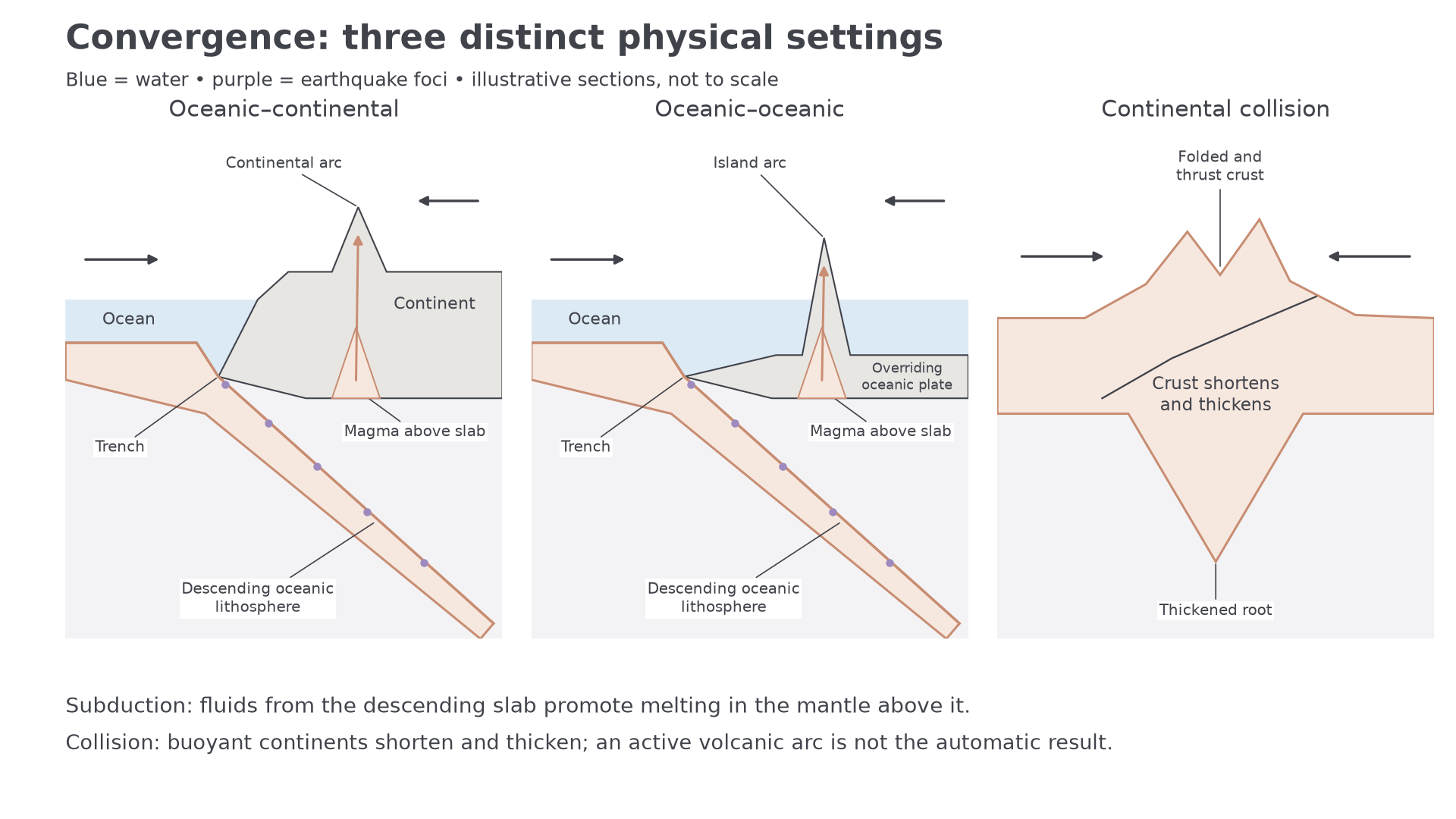
At oceanic–continental convergence, relatively dense oceanic lithosphere can descend beneath an overriding continental margin. Bending at the start of subduction forms a trench, while compression can fold and fault sediment and thicken the continental margin. The Nazca Plate descending beneath South America illustrates this setting: the offshore Peru–Chile trench and the Andes occupy different positions within one convergent system.
The Maule earthquake of 27 February 2010, magnitude 8.8, occurred through thrust faulting on this Nazca–South America interface. It demonstrates that a convergent margin's seismic hazard follows relative motion and locking along the plate contact, alongside the separate volcanic-arc process farther inland. USGS event record and tectonic summary.
Volcanism occurs because the sinking plate carries water in sediments and altered minerals. As conditions change at depth, released fluids enter the overlying mantle wedge and lower the temperature at which partial melting can begin. Buoyant magma rises, may evolve while stored or moving through crust, and feeds a continental volcanic arc. The essential explanation is not that friction melts the entire descending plate. The USGS introduction to subduction explains the connection among plate descent, water and magma.
[DIAGRAM: asset_name: Contrasting convergent boundaries; asset_slug: d34-convergent-sections; caption: Subduction generates a trench, depth-progressive seismicity and an arc, while continental collision thickens crust; description: Three labelled cross-sections compare oceanic–continental subduction, oceanic–oceanic subduction and continental collision. Descending lithosphere, earthquake foci, magma above a slab, continental or island arcs and a thickened collision root are distinguished. Geometry is illustrative and not a measured transect.]
Continue this lesson.
You’re previewing NovaLearn without an account. Create a free account to read the rest.
Create free account