1.1.2 - Glacial erosion and mountain landforms
Glacial erosion depends on moving ice interacting with rock, debris, water and surrounding slopes. This lesson connects weathering, nivation and mass movement with abrasion and plucking, then explains corries, arêtes, pyramidal peaks, troughs, roche moutonnée and striations. It shows how landform shape can reveal process and movement without assuming one mechanism acts alone.
Weathering, nivation and slope processes
A glaciated mountain landscape is shaped by processes around the glacier as well as beneath it. Weathering breaks down or alters rock in place, whereas mass movement transfers material downslope under gravity. These processes supply debris that may later become tools for glacial abrasion.
Freeze–thaw weathering can widen water-filled cracks when temperatures repeatedly cross freezing. Water availability, fracture geometry and the duration of freezing matter; permanently cold, dry rock does not experience an effective freeze–thaw cycle merely because it is below zero. Chemical reactions and biological processes can also operate when liquid water is available, especially in exposed areas after ice retreats.
Nivation is the combined action of processes associated with a persistent snow patch. Meltwater wets and weathers the underlying ground, freezing can weaken material around the patch, and wash or slow downslope movement removes loosened debris. These interactions can enlarge a shallow hollow that traps more snow. Nivation is not itself the erosion of a fully developed glacier, although it can help prepare a site for one.
Steep valley walls supply rockfall, slides and debris avalanches. A block can fall onto ice and be transported far from its source. After deglaciation, slopes may lose support previously supplied by ice, while opening fractures and water infiltration contribute to instability. The loss of support is a possible mechanism whose importance must be assessed locally, not an automatic cause of every post-glacial rockfall.
Energy and material transfers link the processes. Solar and atmospheric energy produce meltwater; gravity moves debris onto the ice; ice flow carries it away; and meltwater later sorts it. A mountain hollow therefore develops through connected snow, slope and glacier systems rather than a single cold-climate process acting in isolation.
Glacial erosion and sediment entrainment
Moving ice erodes effectively when it has appropriate contact with the bed, available debris and conditions that allow rock to be detached. Clean ice is relatively weak compared with many rocks; the sediment it carries often supplies the cutting tools.
Abrasion occurs when debris held at or near the glacier base scrapes and grinds the bed. It can smooth surfaces, cut grooves and produce fine rock flour. Its effectiveness depends on sliding speed, debris size and concentration, contact pressure and rock resistance. Too little debris provides few tools, while a thick protective sediment layer can separate ice from bedrock. Erosion therefore does not increase indefinitely with debris supply.
Plucking, also called quarrying, detaches blocks from jointed bedrock. Pressure changes around bed obstacles, water entering fractures and freezing or refreezing under suitable conditions can help loosen and attach blocks to the moving ice. Reduced pressure on the lee side of an obstacle can favour cavities and block removal. A sound explanation links existing weaknesses, basal conditions and ice motion; it does not require the whole glacier to freeze and thaw each day.
Entrainment is the incorporation of sediment into the moving glacier. Material may arrive from rockfall onto the surface, be buried by snow, or be picked up at the base. Debris can travel on the surface, within the ice or beneath it, usually described as supraglacial, englacial and subglacial transport. Unlike a river, ice does not need to become faster to carry a large block already embedded in it.
When ice melts or releases debris, deposition begins. Meltwater may then sort and transport the material again. This creates a link from erosion of a mountain bed to a deposit several kilometres downstream, with temporary storage between the two. A measured sediment load is therefore evidence of exported material, not a direct map of every place eroded beneath the glacier.
Corries, arêtes and pyramidal peaks
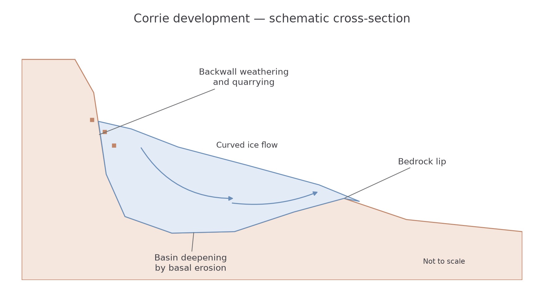
A corrie, also called a cirque, is an armchair-shaped mountain hollow with a steep backwall, an overdeepened basin and a lip at its outlet. Snow can initially persist in a sheltered hollow because of shading, wind deposition or avalanching. Nivation and weathering may enlarge the site before a small glacier develops.
As snow becomes ice, movement transfers it towards the outlet. A curved or rotational flow pattern can promote erosion of the basin floor. Abrasion deepens and smooths suitable bedrock, while quarrying exploits fractures. At the backwall, weathering and removal of debris help the hollow extend backwards. These processes steepen the rear wall and deepen the floor at different locations.
A rock lip can remain where erosion is less effective near the outlet, and deposited debris may add to it. After melting, a lake or tarn may occupy the basin if water is retained. Neither the tarn nor a sediment ridge is required to identify every corrie. Geological structure, later erosion and drainage can modify the classic shape.
[DIAGRAM: asset_name: Corrie development cross-section; asset_slug: p10-corrie-section; caption: Backwall retreat, basin deepening and a less-eroded lip combine to produce a corrie; description: A schematic mountain cross-section shows a steep jointed backwall, ice occupying an overdeepened hollow, curved ice-flow arrows towards a bedrock lip, debris from the wall and arrows identifying basin abrasion and backwall quarrying/weathering. It is not a measured site or a universal sequence.]
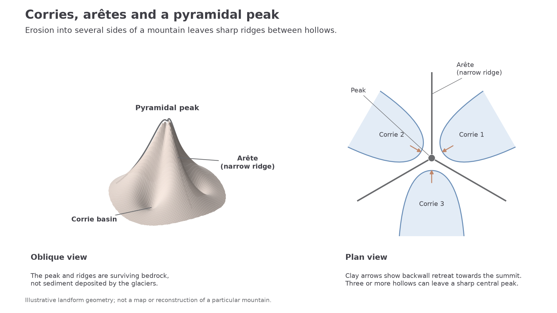
Where two adjacent corries or glacial valleys erode backwards towards one another, a narrow ridge can remain between them. Weathering and rockfall steepen its sides, producing an arête. Where three or more corries cut back towards a common summit, the intervening ridges can converge on a sharp pyramidal peak, or horn. The peak is the remnant left between eroding hollows, rather than a pile deposited by glaciers.
This explanation involves both differential erosion and slope processes. A weak or heavily fractured summit may collapse rather than preserve a perfect pyramid. A landscape's actual shape reflects its rock structure and several glaciations, not necessarily one neatly symmetrical group of simultaneous corries.
[DIAGRAM: asset_name: Corries, arêtes and a pyramidal peak; asset_slug: p10-corries-aretes-peak; caption: Backward erosion into several sides of a mountain leaves arêtes between corries and a sharp summit where ridges converge.; description: An oblique mountain view and a matching plan identify three corrie basins around a central bedrock peak. Narrow ridges separate adjacent hollows. Clay arrows in the plan point from corrie backwalls towards the summit, showing headward retreat rather than glacier flow. The geometry is illustrative and does not reconstruct a named mountain.]
Worked application — reading an eroded hollow
Illustrative resource: a photograph shows a mountain hollow with a steep backwall, a lake in a deep basin and a rock lip at its outlet. With reference to the photograph, explain how one of these features formed. The lake occupies an overdeepened basin. Debris held beneath moving corrie ice abraded the floor, while quarrying removed fractured blocks. Concentrated erosion deepened the hollow more than its outlet, leaving a basin that retained water after deglaciation. The visible lake is linked through the bedrock depression to glacial erosion; it is not itself an agent that excavated the corrie.
Worked explanation — energy, erosion and a named mountain landscape
Explain the influence of glacial erosion on mountain landforms. The Helvellyn account in JNCC's Quaternary of Northern England, drawing on Evans's 1997 survey, describes nine corries on its eastern slopes and identifies Swirral Edge and Striding Edge as intervening arêtes. It records Red Tarn's water area as 9.8 hectares and depth as 25.6 metres. These are the account's dated measurements, not new measurements in 2026. JNCC geological conservation account, chapter 5, printed p194.
Gravity supplied the force for accumulated ice to deform and move out of the hollows. Where debris contacted the bed, movement converted that material into abrasion tools, wearing down the basin floor. Quarrying exploited fractures and removed blocks, while weathering and rockfall supplied further debris from the headwalls. This material could be carried away by ice, allowing the walls to retreat rather than remaining protected by their own debris. Differential erosion left the deeper basin and a less-eroded outlet lip; after the ice disappeared, water could occupy the depression represented by Red Tarn. Retreat into adjacent hollows narrowed the bedrock between them, producing the arêtes. The explanation links energy, debris supply, erosion and transport to contrasting positions in the landform assemblage. Its effectiveness depended on rock structure and basal conditions, so the named ridges are evidence of an interacting system rather than proof that abrasion alone produced every feature.
Troughs, roche moutonnée and striations
A glacial trough is a valley widened and deepened by ice, commonly with a broad floor and steep sides. A glacier often occupies an earlier river valley. Abrasion and quarrying enlarge it while the distribution of thick, moving ice concentrates erosion in particular sections. Valley-side weathering and mass movement further modify its walls.
The resulting cross-section is commonly described as U-shaped, in contrast to an idealised V-shaped river valley. Ice can truncate projecting spurs and overdeepen basins, which may later hold lakes. Smaller tributary glaciers can erode less deeply than a thicker main glacier, leaving hanging valleys above the main trough after the ice disappears. These associated forms help explain the landscape's connectivity. Not every trough is a perfect U: bedrock structures, sediment infilling and later river action alter the outline.
A roche moutonnée is an asymmetric bedrock mound sculpted beneath moving ice. On the upstream, or stoss, side, ice is pressed against the obstacle and debris abrades a relatively smooth, gently sloping surface. On the downstream, or lee, side, pressure and contact conditions can favour quarrying along fractures, leaving a steeper, rougher face. Ice motion is commonly inferred from the smooth stoss side towards the quarried lee side, supported by other evidence.
[DIAGRAM: asset_name: Roche moutonnée process geometry; asset_slug: p10-roche-moutonnee; caption: Ice moving from stoss to lee can abrade the upstream face and quarry the downstream face; description: A schematic cross-section shows left-to-right ice flow over an asymmetric rock mound. The left stoss side is smooth and gently rising; the right lee face is steep and jointed, with removed blocks. Labels connect abrasion, quarrying and inferred movement direction.]
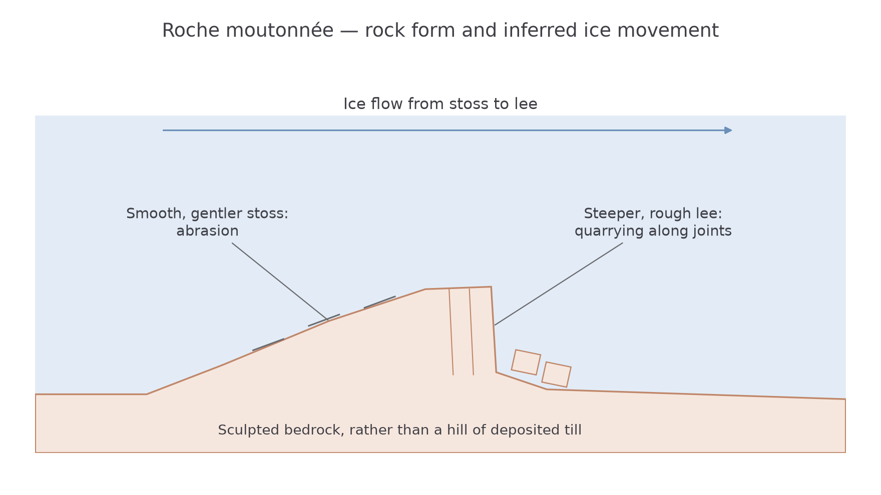
A roche moutonnée is made of bedrock. It should not be confused with a drumlin, which is commonly a streamlined hill of sediment. The asymmetric shapes also provide different directional clues, so identifying material is essential before interpreting flow.
Striations are scratches or grooves cut into rock by debris moved beneath the glacier. They can indicate the orientation of former movement, particularly where several parallel marks occur on a polished surface. A scratch by itself may not establish which of two opposite directions the ice travelled. Cross-cutting striation sets can record changing flow, and later weathering can remove them. Combining striations with roche moutonnée asymmetry, erratic sources and regional landform alignment provides a stronger reconstruction than using one feature alone.
These forms operate at different scales: a scratch records local contact, a bedrock mound records flow around an obstacle, and a trough reflects erosion integrated across a valley. Their coexistence links small-scale process evidence to a larger glaciated landscape.