1.2 - Arctic tundra water and carbon cycles
Alaska's North Slope combines small vegetation stores and a short growing season with water and carbon held in cold ground. This lesson explains the physical and seasonal controls of its tundra cycles, assesses oil and gas development and management, and shows how monitoring can distinguish local disturbance from wider climatic change.
Arctic tundra stores and slow cycling
The Alaska North Slope extends north of the Brooks Range towards the Arctic Ocean, with tundra landscapes that vary from foothills to a low coastal plain.
Low temperatures, a short growing season and frozen ground limit many transfers. Snow is an important seasonal water store, while ground ice retains water for much longer. Lakes, ponds, wet soils and streams occupy parts of the landscape. Low precipitation does not necessarily mean dry soil: low evapotranspiration and restricted drainage can retain water near the surface.
Permafrost and active layer
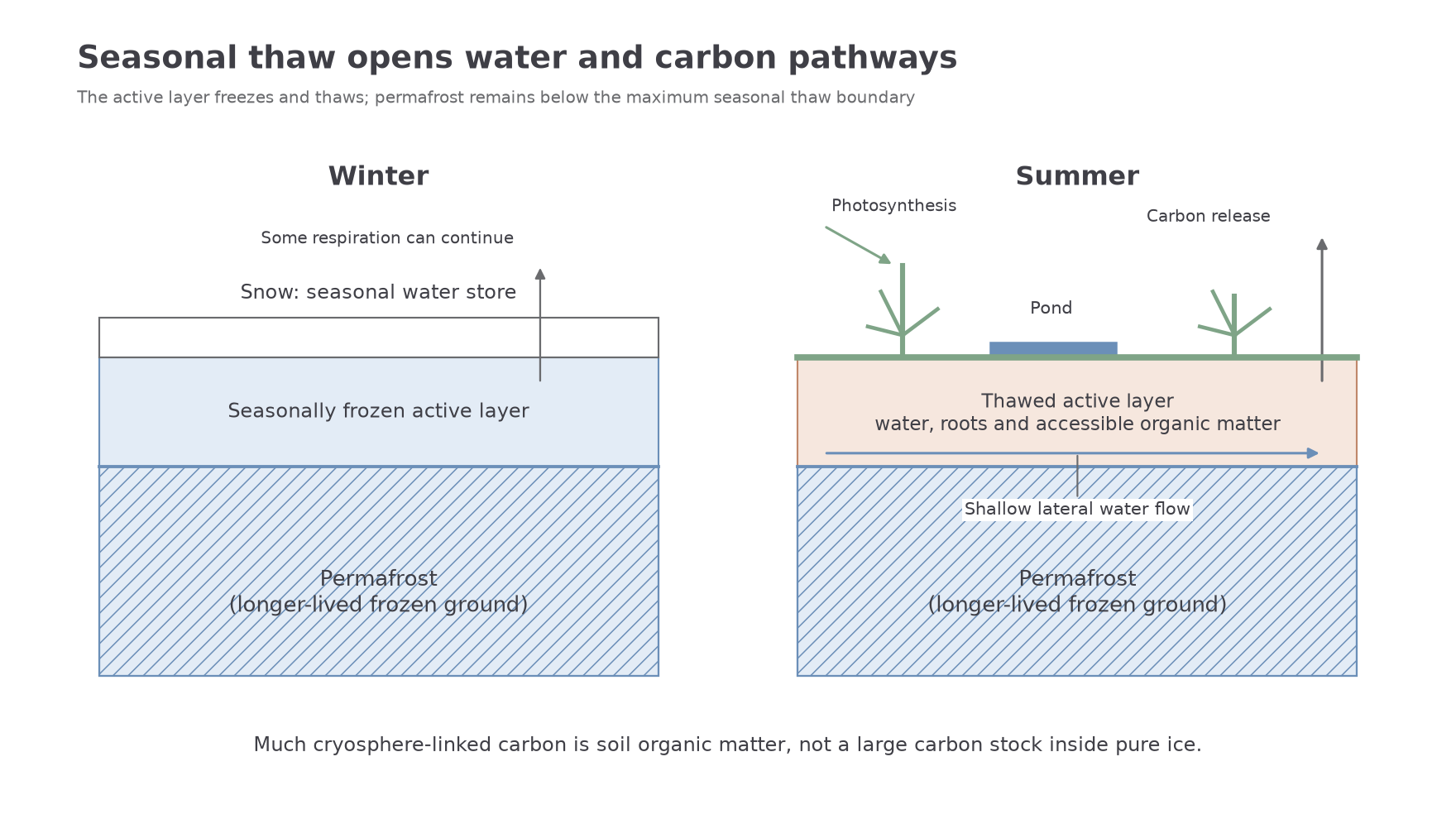
Permafrost is ground that remains at or below for at least two consecutive years. The active layer above it freezes and thaws seasonally. Permafrost is a temperature condition, not a synonym for pure ground ice or for a surface that never thaws.
Tundra plants include mosses, sedges, grasses, lichens and low shrubs rather than tall, dense rainforest trees. Living biomass is comparatively small. Plant growth adds organic carbon during the brief summer, while cold and sometimes waterlogged soils slow decomposition. Organic material accumulated over long periods forms a large soil and permafrost-associated store. Much of this carbon is organic matter within soil, not carbon dioxide imprisoned inside a vast block of pure ice.
“Slow cycling” is a comparison, not a claim that every flux is small at every moment. Spring melt can release a concentrated water pulse; summer plant uptake can be substantial; microbes can continue respiring in unfrozen pockets and beneath insulating snow. A long-established carbon stock also does not guarantee that the modern landscape remains a net sink. NOAA's 2024 Arctic carbon assessment distinguishes increasing plant uptake, respiratory losses and fire effects, with differences between sites and the wider tundra region.
Physical controls on tundra cycles
Temperature, substrate and relief interact to determine which stores can exchange water and carbon during the thaw season.
Freezing reduces access to liquid water and restricts infiltration into ice-filled ground. In summer, the active layer becomes a temporary zone of water storage and lateral flow above less permeable frozen material. The underlying rock may have considerable porosity or fractures, but seasonal freezing can prevent those pathways functioning like those in an unfrozen aquifer. Unfrozen zones below lakes or within some channels can allow deeper connections, so the system is not completely impermeable everywhere.
Porosity controls possible storage, while connected pores and fractures determine permeability when unfrozen. Coarse deposits can drain more readily than fine material, but ice content and soil structure may dominate their short-term response. On the low coastal plain, weak gradients and depressions encourage ponding. Steeper foothill slopes can drain more efficiently and transfer water and dissolved carbon into channels. Small differences in height between polygon centres and rims can create wet and dry patches over short distances.
Vegetation affects both cycles. Moss and organic layers can insulate the ground, while shrubs trap snow that also changes insulation. Roots absorb thaw-season water; leaves take up carbon and transpire. Moisture, nutrients and the length of the thaw season constrain their activity. Warming may increase plant growth, but can also increase decomposition and disturbance losses; the net carbon balance requires both sides of the budget.
Soil organic matter stores carbon and influences water retention. Parent material and rock mineral composition influence nutrients and dissolved weathering products. Carbonate minerals can supply dissolved inorganic carbon, whereas weathering of different silicates supplies different nutrients. Mineral association can protect some organic matter. On short seasonal timescales, however, temperature, drainage and thaw depth commonly exert stronger immediate controls than fresh bedrock weathering. Geological composition matters without overriding the effects of frozen ground.
[DIAGRAM: asset_name: Seasonal tundra water and carbon pathways; asset_slug: p26-active-layer-cycles; caption: Seasonal thaw opens shallow pathways above longer-lived frozen ground.; description: Paired winter and summer cross-sections show snow and a frozen surface in winter, then a thawed active layer above permafrost in summer. Summer arrows indicate shallow lateral water flow, root water uptake, photosynthesis and microbial carbon release. A small pond and organic layer show local storage and insulation. The permafrost boundary is separate from surface snow and the seasonally frozen active layer.]
Seasonal freeze and thaw
Seasonality changes the accessible stores and the timing of water and carbon flows rather than simply speeding every process equally in summer.
Winter precipitation accumulates mainly as snow. Limited sunlight and cold restrict photosynthesis and evaporation. Ground and surface water freeze, reducing liquid flow. Snow insulates the soil, however, so some microbial respiration continues below the surface. Spring snowmelt can arrive while the ground remains frozen, promoting overland and shallow lateral flow. The river's melt peak may therefore precede maximum active-layer depth.
During summer, deeper thaw creates more space for roots, water movement and microbial activity. Long daylight supports photosynthesis, and plants transpire where water is available. Thawed organic matter becomes accessible to decomposers. In aerated patches, carbon dioxide release can increase; in saturated anaerobic patches, methane production can be important. Autumn refreezing restricts pathways again, but heat stored in the soil can sustain respiration after plant uptake has declined. A summer-only measurement can miss a significant part of annual carbon loss.
The following NOAA 1991–2020 normals for Barrow Post Rogers Airport describe one coastal North Slope location. Temperatures have been converted from Fahrenheit to Celsius using ; precipitation is liquid-water equivalent, including snow, rather than snow depth.
| Month | Precipitation, mm | Mean daily minimum, °C | Mean daily maximum, °C |
|---|---|---|---|
| Jan | 3.6 | -27.7 | -20.7 |
| Feb | 5.3 | -27.9 | -20.8 |
| Mar | 4.6 | -27.3 | -19.9 |
| Apr | 4.6 | -19.2 | -11.9 |
| May | 7.1 | -7.5 | -2.8 |
| Jun | 10.9 | -0.5 | 4.9 |
| Jul | 24.9 | 2.0 | 8.7 |
| Aug | 27.7 | 1.7 | 6.9 |
| Sep | 19.6 | -0.9 | 2.8 |
| Oct | 13.7 | -8.4 | -3.6 |
| Nov | 9.4 | -17.8 | -11.4 |
| Dec | 5.6 | -24.6 | -18.0 |
[DIAGRAM: asset_name: Barrow tundra climate graph; asset_slug: p26-barrow-climate; caption: Coastal North Slope normals show a short mild summer and a long freezing season.; description: A graph uses NOAA Barrow Post Rogers Airport 1991–2020 monthly precipitation in millimetres as blue bars and mean daily minimum and maximum temperatures converted to Celsius as two clay-coloured lines. A zero-degree reference line and the two axis units are labelled. Precipitation is liquid-water equivalent and the graph is one coastal station, not a whole-North-Slope average.]
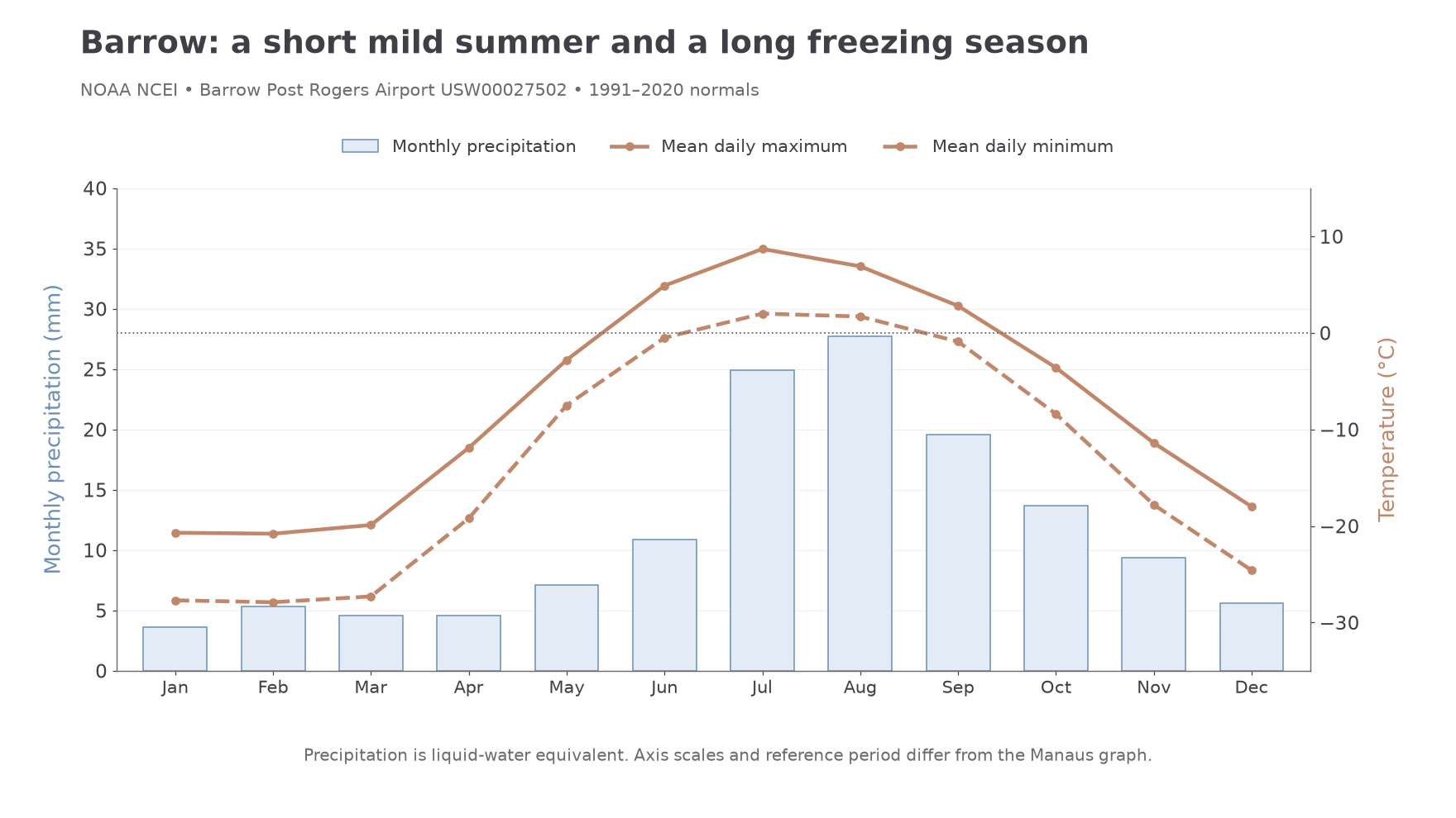
Both temperature statistics differ greatly from those at Manaus, but the climatologies cover different periods: Manaus uses 1961–1990 and Barrow 1991–2020. They illustrate contrasting seasonal environments; subtracting them cannot estimate climate change at either site. Nor does a monthly air normal directly measure ground thaw, which depends on snow, soil and local conditions.
Worked temperature conversions
For an air reading of , subtract 32 before multiplying:
For a separate reading of , keep the negative intermediate value:
Converting air temperatures puts observations into comparable units; it does not convert air temperature into a measurement of ground thaw.
Worked seasonal explanation of linked cycles
Examine how seasonal temperature changes influence water and carbon cycles in tundra. The Barrow 1991–2020 normals show a short mild summer within a long freezing season. Winter stores precipitation as snow and restricts liquid pathways, while limited light reduces photosynthesis. Snow's insulation can nevertheless allow microbial respiration below the surface, so the winter carbon budget remains active even when the visible landscape is frozen.
Spring warming melts snow before the whole soil profile thaws. Stored water is released rapidly over frozen ground, increasing surface and shallow flows. Continued heating later deepens the active layer, providing roots and microbes with a larger accessible zone. Water availability supports plant uptake and transpiration, while decomposition transfers soil carbon into gases. Drainage determines the form and rate of release: aerated soil favours carbon dioxide production, whereas waterlogged anaerobic patches can release methane. The same temperature rise therefore affects the cycles through different stores and thresholds rather than simply increasing every transfer together.
An illustrative seasonal resource showing a meltwater peak in May and deepest thaw in August would be explained through this timing difference. For a short resource explanation, identify the peak, link it to snow storage release, then link delayed deep thaw to accumulated summer heat. For the carbon link, explain how prolonged thaw can increase respiratory losses after plant uptake declines. NOAA's 2024 assessment consequently treats annual uptake, respiration and fire together. Longer growing seasons can increase uptake, but their net storage effect depends on the complete annual balance and local moisture conditions.
Oil and gas development impacts
Oil and gas development around Prudhoe Bay and within the National Petroleum Reserve-Alaska introduces local disturbances into tundra cycles while connecting geological carbon to wider energy use.
Roads, pads and buildings can remove or bury vegetation and insulating organic layers. Heat from infrastructure or altered snow accumulation can deepen thaw; melting ground ice may cause subsidence and change surface drainage. A raised road can impede lateral flow, making one side wetter and another drier, unless crossings maintain drainage. These hydrological differences influence both plant uptake and decomposition, so the sign of a local carbon response can vary.
Water withdrawn from lakes or streams for industrial use and ice-road construction changes seasonal storage. Winter is sensitive because ice already reduces the liquid water available. Excessive withdrawal can affect later storage and connections, while summer melt of an ice road returns water at a different time or place. Fuel use, flaring and leakage introduce additional carbon pathways. Carbon removed as oil is an output from the local geological store; much combustion occurs elsewhere, so it must be included only within an appropriately wider carbon boundary.
The USGS 2024 Greater Mooses Tooth study compared stream samples from 2010 and 2023, including developed catchments and a reference site. Water-quality characteristics were generally similar across these snapshots. This constrains claims: plausible disturbance pathways do not establish that every developed stream has become severely polluted. Sparse sampling also cannot demonstrate that no seasonal or longer-term hydrological change occurred.
Worked active-layer comparison
Illustrative dataset: at a matched late-summer date, a site beside infrastructure deepens from 50 to , and a reference site from 40 to . Calculate each change before subtracting:
Regional warming affects both sites, while snow, soil ice and vegetation may differ. The extra 8 centimetres supports investigation of a local effect but does not isolate its cause.
Worked pipeline comparison
Illustrative dataset: another site changes from 38 to 56 centimetres beside a pipeline, while its reference changes from 42 to 54 centimetres. Repeat the method:
The reference already has deeper thaw initially, so comparing final depths alone would miss the different changes. Repeated matched transects, pre-development baselines and several references strengthen attribution.
Moderating industry impacts
Management can reduce heat, surface disturbance and drainage disruption, but each method needs monitoring and appropriate site conditions.
Elevating suitably designed pipelines and buildings can reduce direct heat transfer into frozen ground and leave space for air circulation. Insulation and passive cooling systems, such as thermosyphons where suitable, help remove heat during cold conditions. These methods protect the thermal regime rather than making ground immune to regional warming. Foundations, spacing and changing snow conditions affect performance.
Road crossings and culverts maintain natural drainage pathways; a culvert that is too small, blocked or poorly positioned may still cause ponding or erosion. Concentrating several wells on one pad using directional drilling can reduce the footprint of roads and vegetation clearance, though the remaining infrastructure continues to alter its immediate surroundings. Water-use controls can limit withdrawal from vulnerable winter stores and require monitoring of lake levels and remaining liquid water.
Seasonal access on adequately frozen, snow-covered surfaces can reduce damage relative to repeated summer passage. Ice roads avoid a permanent gravel road in some locations but consume water and are not impact-free. A BLM study of ice-road traces surveyed in 2001–2002 found vegetation damage differed among terrain types, with greater impacts on some dry uplands. Its older 1978 road trace showed recovery by the survey period. That evidence does not guarantee identical recovery times at every road or prove that each new road has unchanged ground conditions.
The technical principle is to limit the initiating disturbance and preserve the system's drainage and insulation. Success should be judged by vegetation recovery, ground temperatures, active-layer depth, water levels and carbon fluxes over time, rather than the presence of a particular engineering device alone. The historical study demonstrates management evidence; it is not a statement that its procedures are the complete legal requirements applying to every North Slope project in 2026.