1.1.3 - Dryland erosion, weathering and landforms
Dryland landforms reflect the interaction of weathering, gravity, occasional water flows and wind. This lesson explains how these processes release and transfer sediment, how wadis and canyons develop, and why pedestal rocks, ventifacts and stone pavements require particular combinations of rock, sediment and energy.
Dryland weathering and mass movement
Weathering breaks down rock in place, whereas mass movement transfers rock or soil downslope under gravity.
Large temperature changes can create stresses as a rock's surface and interior heat or cool at different rates. Minerals also expand differently. Repeated stresses can help loosen grains or flakes, particularly in already fractured rock. Temperature range alone does not demonstrate rapid breakdown: rock properties, heating rates and previous weaknesses matter. Salt weathering occurs where saline moisture enters pores or joints and salt crystals grow as conditions change, exerting stress on the rock. A supply of moisture is needed even in a very dry climate.
Chemical reactions also occur in drylands. Water can dissolve soluble minerals or react with minerals in joints and beneath soil. Such weathering is usually limited by moisture but can be significant during wetter episodes or over a long period. On cold uplands, freezing conditions can assist rock breakdown where water reaches cracks. A dry rock that simply becomes cold does not automatically undergo frost shattering.
Weathering prepares sediment for transport. A jointed cliff may release blocks in a rockfall when weathering or undercutting weakens support. Gravity supplies the downslope driving force; the fall converts potential energy into movement. Loose debris can accumulate as scree at the foot of a slope. During intense rain, water adds weight, raises pore-water pressure and reduces friction. A sediment–water mixture may then move as a debris flow, carrying material much coarser than a low-discharge stream could normally transport.
These processes are linked. Long intervals of rock breakdown may build a slope store; one storm can empty part of it into a channel. Neither constant rapid erosion nor complete inactivity describes all drylands. Evidence such as fresh scars, angular blocks and sediment lobes helps identify the processes and their relative timing.
Flash floods, wadis and canyons
Water can perform intense erosional work in drylands even where channels remain dry for most of the year.
A flash flood is a rapid rise in flow following a short-lived input such as intense rainfall. Where rainfall exceeds infiltration, overland flow reaches channels quickly, particularly on steep, sparsely vegetated slopes. A storm upstream may cause flooding downstream beneath a clear sky. Discharge can rise quickly, increasing the force available to entrain material and the size of particles the water can move.
Hydraulic action loosens material through the force of moving water, while sediment carried by the flow abrades the channel bed and banks. Fine particles travel in suspension; sand and gravel move intermittently along the bed by rolling, sliding or saltation. Dissolved minerals are transported in solution. When flow spreads, infiltrates into a permeable bed or declines after the storm, transport capacity falls and sediment is deposited. Coarse debris may remain nearer the mountain front while finer material travels farther, though debris flows and changing channels complicate simple sorting patterns.
Wadi
A dryland valley or channel that normally carries water intermittently, especially after rain. Its present flows may be too small or infrequent to explain its entire inherited size.
Concentrated runoff repeatedly scours a wadi and removes weathered debris. A canyon is a deep, steep-sided valley, commonly incised into bedrock. Incision requires the river to erode downward over time; uplift or a lowered base level can maintain a steep gradient. Joints, faults and contrasts in rock resistance guide its course and produce steps or cliffs. Sidewall weathering and rockfalls supply further sediment. A narrow canyon in a desert is therefore not evidence that wind carved it.
A large wadi can also preserve drainage established under a wetter climate. Today's flash floods may modify a much older valley. Distinguish the process that originally created a landform from the process now reworking it. The National Park Service's account of Death Valley's August 2023 Hilary floods documents event-scale changes to canyons and fans; it does not imply that the whole canyon system formed in that event.
Worked resource application — erosion recorded in a canyon
Illustrative resource: a canyon photograph shows narrow grooves cut into its bedrock floor, loose angular blocks below jointed walls and rounded pebbles in the channel. With reference to the photograph, explain one process shaping the canyon. The pebbles provide tools for abrasion when a flood moves them across the bed. Repeated impacts and grinding remove bedrock and can deepen the grooves shown in the floor. The explanation connects an observed sediment supply with moving water and the particular erosional feature, rather than attributing the canyon's entire age or depth to one photograph.
Worked explanation — the influence of water on dryland landforms
Explain the influence of water on dryland erosional landforms. Water operates episodically, but concentration of discharge gives individual events substantial erosive capacity. In Death Valley, the 19–21 August 2023 Hilary event brought rain to slopes and channels; NPS recorded floodwater in Gower Gulch near Zabriskie Point and damage including undercut roads and debris-covered routes. These observations demonstrate rapid reworking, while the bedrock canyon framework records a much longer history.
Where rainfall exceeds infiltration, runoff from several slopes converges in a wadi. Discharge and water depth rise, increasing the stress applied to the bed and banks. Hydraulic action can loosen material, while entrained stones abrade rock and remove weathered debris. This connects a water input to the tools and force needed for incision. Joints and bedding guide removal and help produce steep sides or bedrock steps; later weathering and rockfalls supply new blocks for subsequent floods. Over repeated events, downward erosion can deepen a canyon, especially where uplift or base-level change maintains gradient. The water does not have to flow continuously for the accumulated work to be substantial. Equally, today's smaller intermittent stream may be reoccupying drainage inherited from a wetter interval. The explanation therefore distinguishes observable event processes, cumulative landform development and the rock and relief controls that shape the response.
Aeolian erosion and sediment transport
Aeolian processes are driven by wind, but erosion begins only when the stress applied to the surface exceeds the resistance of available particles.
The entrainment threshold depends on grain size, weight, moisture and cohesion as well as wind speed. Dry, loose sand is often readily moved. Larger stones are heavy, while very fine clay particles can stick together and resist initial detachment. Crusts and vegetation further raise resistance. Once lifted, small dust particles can remain aloft even though they were initially difficult to detach.
Deflation removes loose particles and can lower or hollow a surface. Abrasion is the impact of wind-driven grains against a rock or other surface. Wind provides the transporting energy; the grains are the abrasive tools. Bare rock with no supply of sand can experience little abrasion despite strong winds.
Transport takes three main forms. In suspension, fine dust remains within turbulent air and can travel far beyond its source. In saltation, sand grains make repeated short hops close to the surface. Their impacts eject other grains and maintain transport. In surface creep, larger grains roll or slide following wind stress or impacts from saltating grains. Most sand abrasion is consequently concentrated relatively close to the ground, rather than uniformly through the atmosphere.
[DIAGRAM: asset_name: Aeolian transport pathways; asset_slug: p16-wind-transport; caption: Wind transfers dust, sand and coarser grains along different pathways.; description: A schematic cross-section shows fine dust in suspension, sand following short saltation arcs, and larger grains moving by surface creep after saltation impacts. Sand striking a rock illustrates abrasion. Labels distinguish transport pathways from the entrainment threshold and state that the drawing is not to scale.]
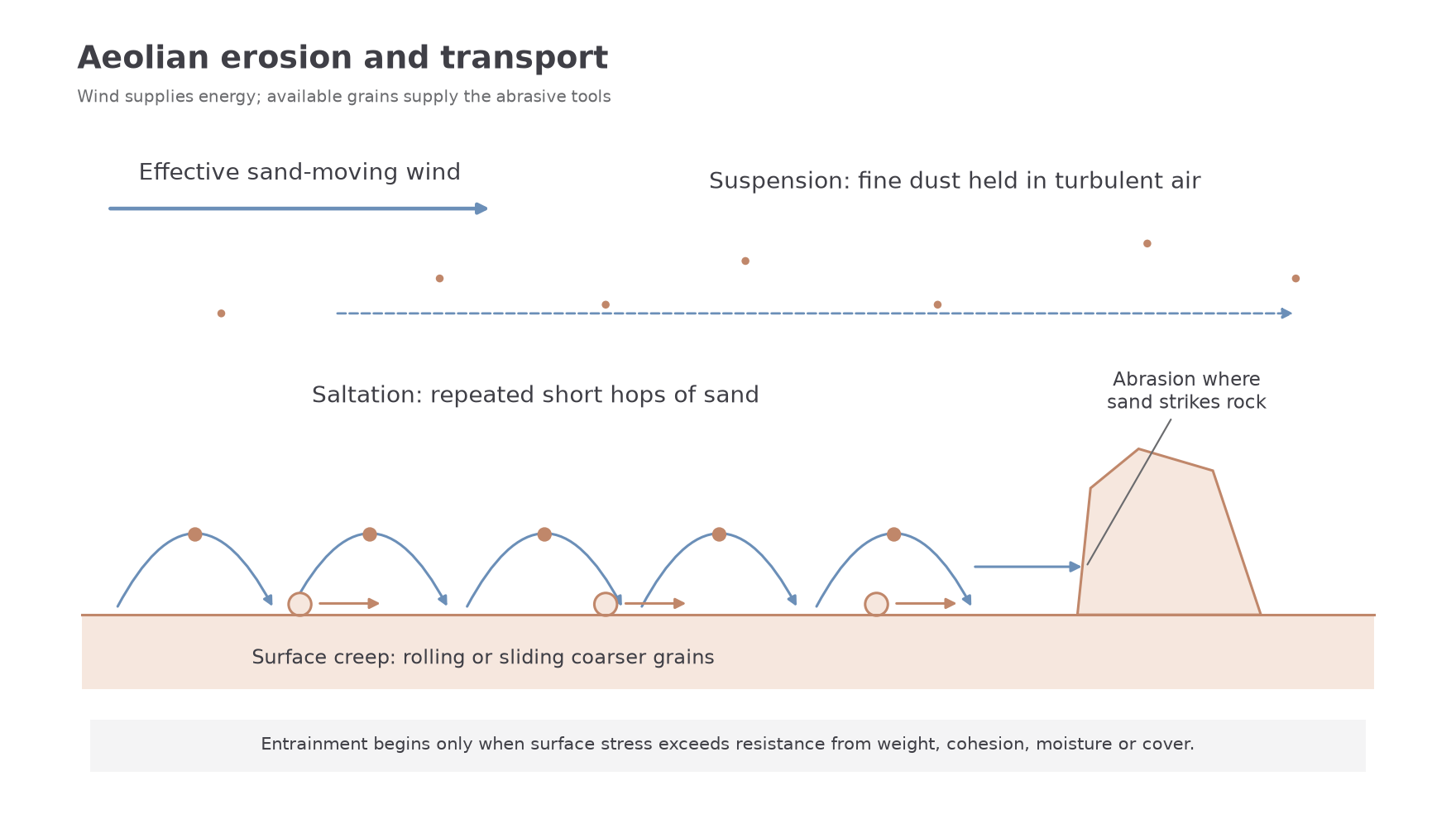
Deposition occurs when the wind can no longer carry its load, for example where surface roughness, vegetation or an obstacle slows flow. Moisture can also trap particles. A fall in wind energy alone does not create a dune without a sand supply. USGS's account of aeolian processes distinguishes these transport mechanisms and the resulting erosion and deposition.
Pedestal rocks, ventifacts and pavements
Wind-related landforms record selective erosion and surface protection rather than a single uniform process.
A pedestal rock has a relatively narrow lower section beneath a broader upper section. A supply of saltating sand can abrade the lower rock preferentially, undercutting its base. A resistant upper layer above weaker material may strengthen the contrast. Weathering can also help produce or enlarge the shape. Identifying the shape alone does not prove that wind was its only cause; compare rock strength, jointing and the direction and height of abrasion.
A ventifact is a stone whose surface has been polished, grooved or faceted by wind-driven sediment. Abrasion acts most effectively on the exposed face. A stable stone in a persistent wind may develop a clear facet; rotation or changing effective wind directions can expose additional faces. Rock hardness and the supply of abrasive grains control how quickly the surface changes. Facets are evidence of past abrasive transport, but their orientation need not represent the present wind if the stone has moved.
A desert pavement is a closely packed surface cover of stones above finer material. Deflation and occasional runoff can remove fines, leaving coarse fragments concentrated as a lag. As the cover develops, stones shield the underlying surface and reduce further sediment loss: a negative feedback on deflation.
However, not every pavement is simply a residue after a thick layer of fines was blown away. Research summarised in a USGS 2008 Mojave Desert field guide also describes wind-blown dust accumulating beneath surface stones as soils develop. Movement and rearrangement can keep stones near the surface. The precise history requires evidence from the soil profile and deposits beneath the pavement, not just a photograph of the stones. Pavement protection also explains why a visually bare desert surface may supply little sand to nearby dunes.