3.3 1.a, 1.b - Ocean basins, water properties and circulation
The oceans form one connected water body with contrasting basins, landforms and water properties. This lesson locates the major oceans, compares their size, explains horizontal and vertical variation in temperature and salinity, and traces the surface and deep circulation that redistributes heat and materials.
The global distribution of oceans
The Pacific, Atlantic, Indian, Southern and Arctic Oceans are named divisions of a connected global ocean. The Pacific lies between Asia and Australasia to the west and the Americas to the east. The Atlantic separates the Americas from Europe and Africa. The Indian Ocean lies between eastern Africa, southern Asia and Australia. The Arctic surrounds the North Pole, largely enclosed by northern continents; the Southern Ocean encircles Antarctica and connects the southern parts of the other major basins.
Ocean boundaries are conventions rather than walls. A comparison must use the same treatment of marginal seas and the Southern Ocean. The following rounded figures regroup NOAA's ETOPO1 reference data published in 2010, reproduced in the Ocean Exploration Trust's data table. The Pacific row combines that table's Pacific and separately listed South China Sea; the Atlantic includes its listed marginal seas. Volumes here are approximate calculations from the reference areas and rounded mean depths, rather than new measurements.
| Ocean grouping | Approximate area, million | Approximate volume, million |
|---|---|---|
| Pacific, including the listed South China Sea | 168.7 | 669.9 |
| Atlantic | 85.1 | 310.4 |
| Indian | 70.6 | 264.0 |
| Southern | 22.0 | 71.8 |
| Arctic | 15.6 | 18.7 |
The Pacific is largest by both measures; the Arctic is smallest and relatively shallow. Area alone cannot determine volume. In a simplified basin, volume equals surface area multiplied by mean depth, with consistent units. A deep basin can therefore hold much more water than a similarly sized shallow one. Actual bathymetric calculations integrate many depths, as explained by NOAA's global relief model programme.
Worked example — estimating basin volume
Illustrative dataset: a basin has area 2 million square kilometres and mean depth 3 kilometres.
Worked example — a wider, shallower basin
Illustrative dataset: another basin has area 7 million square kilometres and mean depth 1.5 kilometres.
Maximum depth cannot replace mean depth: multiplying the entire area by a trench's deepest point would overestimate the volume.
Worked resource critique — comparing ocean basins
Illustrative resource: a three-dimensional bar chart titled “The world's oceans” labels Pacific 169, Atlantic 85 and Indian 71. It supplies no units and omits the Southern and Arctic Oceans. Its perspective makes the front faces of equal-width bars appear different in size. Identify three limitations of the presentation technique. Missing units prevent the viewer deciding whether values represent area, volume or another measure. Omitting two oceans makes the coverage incomplete for the title. Three-dimensional perspective distorts visual comparison between the bars. These are distinct limitations of labelling, coverage and graphical form, rather than unsupported criticism of the underlying ocean measurements.
Ocean basin relief
Bathymetry describes the shape and depth of the sea floor. Ocean basins contain continental margins, deep plains and tectonic relief; they are not uniform bowls. Understanding their formation helps explain why resources, habitats and hazards occur in particular places.
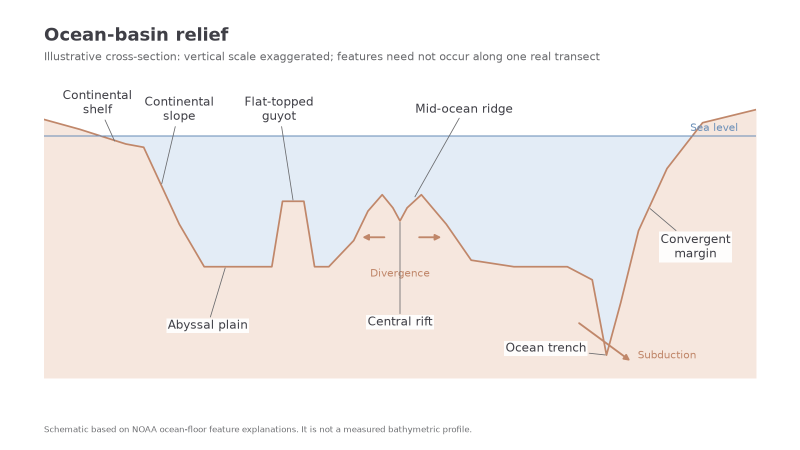
A continental shelf is the gently sloping submerged edge of a continent, exemplified by much of the North Sea. Its width varies greatly. At the shelf edge, the continental slope descends more steeply towards the deep basin. Sediment transported from land and down submarine slopes can cover rough crust, creating broad, relatively flat abyssal plains, commonly several kilometres below the surface. Not every deep area is flat, and a continental margin can contain canyons and other irregularities. NOAA's ocean-floor overview distinguishes these features.
At divergent plate boundaries, upwelling mantle and magma create new oceanic crust along an ocean ridge, such as the Mid-Atlantic Ridge. Hot, relatively buoyant lithosphere gives the ridge its elevated position. A rift valley is a central depression formed by extension and faulting, especially prominent at slow-spreading ridges. Moving away, the crust cools, thickens and subsides. This links ocean relief to plate movement rather than assuming a ridge is a pile of sediment.
At convergent boundaries, one plate can bend down into a subduction zone, producing a long, narrow ocean trench. The Mariana Trench lies in the western Pacific and illustrates this contrasting setting. A guyot is a flat-topped submerged volcanic mountain. A volcano can be eroded near sea level, then carried away from its original setting and lowered as the underlying plate subsides. Its flat summit records that history rather than proving that the sea floor was always flat. NOAA explains guyots and sea-floor mapping.
[DIAGRAM: asset_name: Ocean basin landforms; asset_slug: d17-ocean-basin-relief; caption: An illustrative cross-section distinguishes continental margins, a spreading ridge, a guyot and a subduction trench; description: A schematic basin profile labels continental shelf, continental slope, sediment-covered abyssal plain, a flat-topped guyot, a mid-ocean ridge with central rift, and an ocean trench beside a convergent margin. Vertical relief is exaggerated and the arrangement is not a surveyed transect.]
Continue this lesson.
You’re previewing NovaLearn without an account. Create a free account to read the rest.
Create free account