2B.7 - Sea-level change and coastal landscapes
Learn why sea level changes relative to land, how this leaves distinctive coastal landscapes, and why long-term processes and sudden tectonic movements create different risks.
Water and land can both move
A coast responds to the height of the sea relative to its land, rather than to global sea level alone. Eustatic change changes global ocean level: storing water in continental ice lowers it; melting land ice returns water to the ocean. Warming seawater expands, increasing ocean volume without adding water. Melting floating sea ice has little direct effect compared with land ice because it already displaces seawater.
Relative sea level
Sea-surface height measured against the land at a particular coast. It rises if the sea rises, the land sinks, or both.
Isostatic adjustment is the response of the crust to changing loads. Ice loading depresses land; unloading after melting allows rebound, which continues long after the ice disappears. Areas around an ice sheet may have been pushed upwards as a forebulge, then subside as it relaxes. Sediment loading can depress a basin, while compaction or groundwater withdrawal can cause local subsidence. Accretion may build a coastal surface upwards if sediment deposition keeps pace with rising water. Tectonic uplift and subsidence also change land level, sometimes abruptly; these are land-level changes but not all are isostatic mechanisms.
For an original illustrative coast, a sea rise of 4 mm/year and land uplift of 2 mm/year give a relative rise of 2 mm/year. Land subsidence of 2 mm/year instead gives 6 mm/year. Keep the sign convention explicit: upward land movement is subtracted from sea-surface rise. Regional ocean circulation and gravitational effects mean a global mean is not identical to the local rate.
Raised beaches and fossil cliffs
An emergent coast develops where relative sea level falls, exposing land formerly reached by the sea. Uplift may exceed eustatic rise, or sea level may fall while land remains stable. Waves previously cut a cliff and platform and deposited beach material at the old shoreline. Once lifted beyond normal wave attack, the beach becomes a raised beach and the cliff behind it becomes a fossil cliff. A new active beach and cliff may form lower down.
Use the paired profiles below as exact original illustrative height data, not observations from a named place. Profile A has a level surface at 10 m and a steep slope behind it; Profile B has a deep valley floor below present sea level. Height alone cannot prove marine origin. Rounded beach gravels, shells and a consistent former shoreline level strengthen the raised-beach interpretation; a flat terrace could instead have been formed by a river.
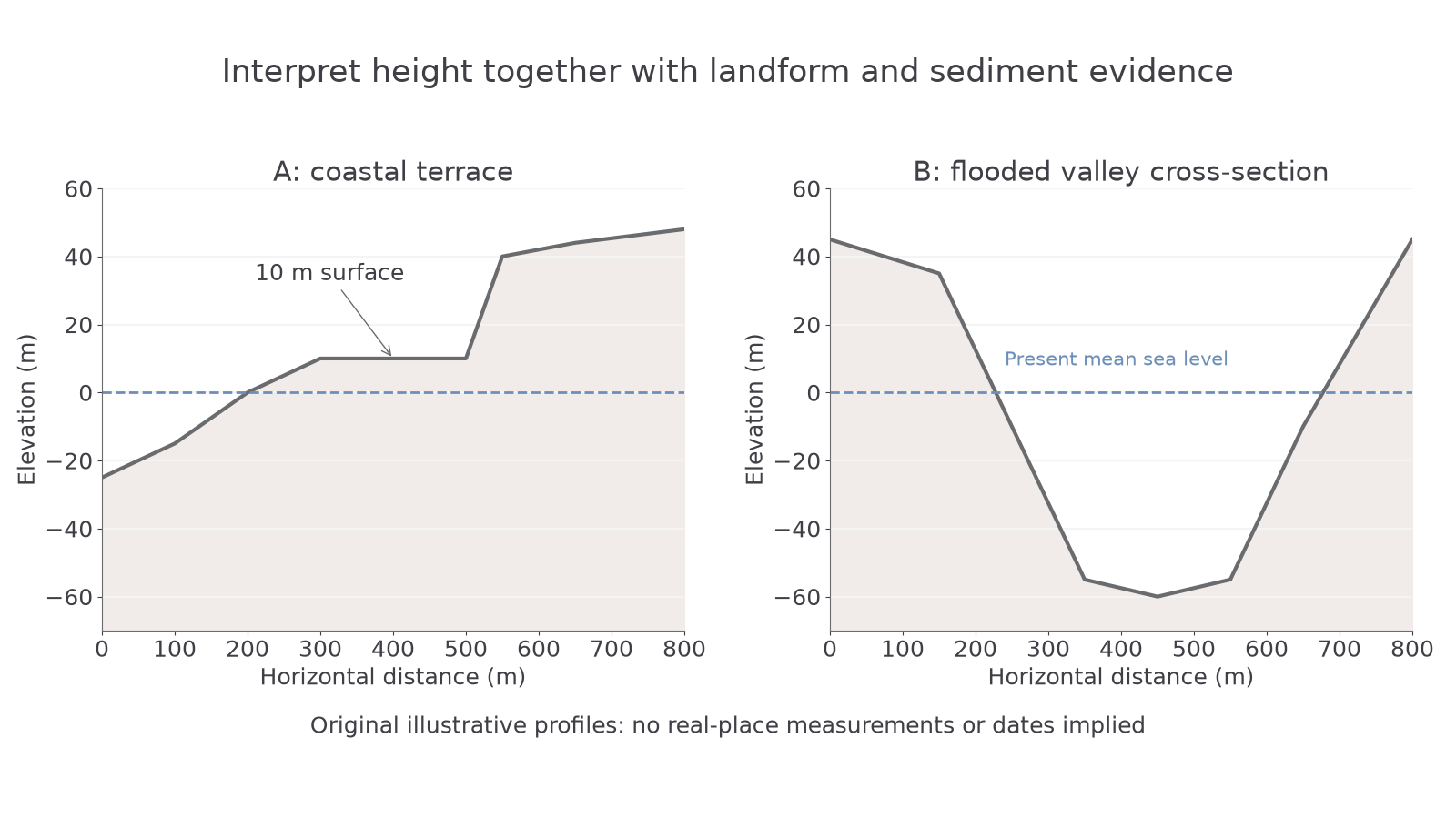
Original illustrative profiles. The dashed line is present mean sea level; distance and elevation axes permit comparison, not dating.
Emergence can improve access to dry land but leave harbours stranded and disrupt shallow-water habitats. The resulting landform records relative change, not necessarily a fall in global ocean volume.
Different valleys produce different drowned coasts
A submergent coast forms where relative sea level rises and floods existing relief. The shape depends on the landscape that was there before flooding.
| Landform | Pre-existing relief and resulting coastal pattern | Useful distinguishing evidence |
|---|---|---|
| Ria | A river valley is partly drowned, creating a branching inlet which generally widens and deepens seawards. | Tributary-shaped branches; comparatively gentler valley sides; submerged fluvial valley floor. |
| Fjord | A glacial trough is drowned, creating a deep, steep-sided inlet. | U-shaped cross-section, hanging tributary valleys and often a shallow threshold or sill near the mouth. |
| Dalmatian coastline | Valleys between elongated ridges running parallel to the coast are drowned. | Long narrow islands and channels parallel to the mainland; the islands are former ridges. |
Do not infer a fjord merely because an inlet is narrow: a river can also cut a narrow valley. Submergence explains water entering the valley, while river or ice erosion explains the original valley shape. Likewise, the alignment of Dalmatian islands records geological structure as well as later sea-level change.
For map and aerial interpretation, first orient the coast and check scale. Trace the main inlet and tributaries; compare contour spacing and offshore depths, then note island alignment. A plan-view image shows branching or parallelism well but hides submerged valley depth. Combine bathymetry, contour maps, glacial landforms and sediment evidence before assigning a cause. In satellite imagery, sediment-rich shallow water may appear light without being dry land; compare tide and image dates.
Slow rise and sudden tectonic change
Contemporary warming raises sea level through thermal expansion and land-ice loss. A higher starting water level allows the same tide or surge to reach farther inland, while beaches and marshes need space and sediment to adjust. Risk is greatest where low elevation, subsidence and dense development coincide. An uplifting coast may experience less relative rise than a subsiding delta even under the same global trend.
Change need not be gradual. On 27 March 1964 the Alaska earthquake produced extensive uplift and subsidence. USGS's 1965 investigation recorded maximum subsidence of 2.3 m in the subsiding zone. This permanently changed some coastlines' relative levels; the accompanying tsunami was a separate, short-lived wave hazard. Do not describe every tectonic sea-level effect as a tsunami.
Landforms record the combined history of ocean level, vertical land movement and the pre-existing landscape. Future coastal risk therefore requires local land and water measurements as well as a global projection.