1.3 - Earthquake, volcanic and tsunami processes
Learn how seismic waves, volcanic materials and displaced seawater create primary and secondary hazards, and how tsunami travel-time information supports a warning decision.
Seismic waves and ground movement
An earthquake releases energy when rock ruptures and a fault slips; seismic waves carry part of that energy away from the focus. A rupture can also reach the surface, producing permanent displacement across a fault. This surface fracturing is distinct from the oscillating ground motion produced by waves, although shaking can create additional cracks and failures.
P waves are compressional body waves: particles move backwards and forwards parallel to the direction of wave travel. They travel through solids and liquids and normally arrive first. S waves are shear body waves: particles move perpendicular to the travel direction. They pass through solids but not liquids and arrive after P waves. L waves are surface waves; Love waves produce horizontal shear and Rayleigh waves produce a rolling motion. Surface waves travel along the Earth's surface and can produce large, prolonged ground movement.
Shaking damages buildings by accelerating the ground beneath them. Inertia makes parts of a building respond differently; large strains can exceed the strength of walls, joints or foundations. Frequency, amplitude and duration all matter. Soft sediments may amplify some shaking, and a building's response depends on its design as well as the event. It is therefore unsafe to say that one wave type always causes all damage or that magnitude alone determines local shaking.
Liquefaction and earthquake-triggered landslides
Ground shaking can trigger other hazards where local materials and topography are susceptible. These secondary hazards explain why damage may be concentrated away from the main fault trace.
Liquefaction is a temporary loss of strength in loose, water-saturated granular sediment. Repeated shaking tends to rearrange grains. If water cannot drain quickly, pore-water pressure increases, reducing the effective contact forces between grains. Sediment may then behave like a fluid: foundations lose support, buildings settle or tilt, and ground can spread laterally towards a river or coast. The rock itself has not melted. Loose saturated sands and silts are more susceptible than well-cemented bedrock; both ground conditions and shaking are necessary to explain the risk.
Earthquake-triggered landslides occur when shaking increases destabilising forces or weakens material on a slope. Steep slopes, fractured rock, loose deposits and wet ground can increase susceptibility. A slide may bury settlements, block roads or dam a river, generating a later flood if the dam fails. The earthquake is the trigger, while slope properties and water conditions explain where failure occurs.
For example, two equally distant districts can experience different ground failure: a flat district on loose saturated river sediment may liquefy, whereas a steep mountainous district may experience rockfalls and landslides. A physical-hazard map should therefore combine shaking with substrate, slope and groundwater evidence. It cannot identify ground failure reliably from distance to an epicentre alone.
Lava, pyroclastic flows, ash and gases
Volcanic eruptions produce different hazardous materials with different pathways and spatial footprints. Lava, pyroclastic flows and ash are not interchangeable descriptions of an eruption.
Lava flows are molten rock moving across the surface. They can bury or burn buildings, roads and vegetation; their speed depends on viscosity, supply rate and slope. Many flows permit evacuation, but fast-moving fluid lava can still threaten life. Pyroclastic flows are rapidly moving mixtures of hot fragments and gases, generated by processes such as collapse of an eruption column or lava dome. Their temperature, speed and impact can be lethal. Dense flows often follow valleys, while more dilute surges may cross terrain obstacles; a safe route cannot be chosen merely by walking uphill nearby.
Ash consists of fragmented rock and volcanic glass rather than ordinary combustion ash. Fine particles can travel far downwind. Ash fall can damage crops, contaminate water supplies, impair breathing and reduce visibility; wet ash loads can collapse roofs. Ash reaching jet engines can create serious aircraft hazards. Wind direction and plume height therefore affect which distant areas are exposed.
Volcanoes also emit gases. Sulfur dioxide can irritate breathing and contribute to acid deposition; carbon dioxide can accumulate in depressions and displace breathable air. Fluorine compounds can contaminate grazing land and water. Concentration, ventilation and duration of exposure affect severity. A quiet-looking volcano may emit hazardous gas without a spectacular explosive eruption.
Lava and dense pyroclastic flows are strongly influenced by relief. Ash and gases are also transported by air, so a volcanic hazard can extend far beyond the mountain's slopes.
Lahars and jökulhlaups
Water can remobilise volcanic material or be released suddenly by an eruption, producing major hazards beyond the vent. Secondary does not mean minor or necessarily delayed for a long time.
A lahar is a flowing mixture of water and volcanic sediment or debris. Intense rainfall on loose ash, melting snow or ice, or release of water from a crater lake can supply the water. The mixture can travel rapidly down drainage valleys, bury settlements, destroy bridges and continue far downstream. It can occur during an eruption or months to years afterwards while unconsolidated material remains available. A river valley outside a lava-flow zone is therefore not automatically safe.
A jökulhlaup is a sudden glacial outburst flood. Beneath an ice-covered volcano, geothermal or eruptive heat may melt ice and accumulate water; failure of an ice dam or opening of a drainage route can release it rapidly. Floodwater erodes and carries sediment, damaging roads, bridges and farmland. Glacial outburst floods can also occur without a volcanic eruption, so the word describes the flood mechanism rather than a uniquely volcanic event.
The hazards can overlap but should not be treated as synonyms. A lahar is defined by its sediment-laden volcanic mixture; a jökulhlaup by sudden release of glacial water. A flood from melting ice may pick up enough volcanic debris to become a lahar. In both cases, valley geometry controls routing and the water supply controls timing and volume.
From fault displacement to coastal inundation
A large submarine subduction earthquake can generate a tsunami when abrupt vertical seabed movement displaces the overlying water column. A locked plate interface may accumulate strain for years; sudden slip lifts or lowers a broad area of seabed, disturbing the sea surface. Gravity then restores the disturbed water surface and long waves spread away from the source.
The energy travels across the ocean; the same parcel of water does not move from the source to every receiving coast. In deep water, a tsunami may have a very long wavelength and a small wave height, making it difficult to notice from a ship. As it enters shallower water, it slows, its wavelength shortens and its height may grow through shoaling. Coastal shape, seabed relief and interactions between waves modify the local outcome. Inundation is the water flooding onto land; run-up describes the maximum vertical elevation reached above a reference sea level.
A tsunami is a wave train, so the first arriving wave need not be the largest. Currents and later waves may remain dangerous after an initial withdrawal or surge. Tsunami-generating earthquakes require favourable displacement, not merely a large numerical magnitude. Submarine landslides and volcanic collapses can generate tsunami waves by a different displacement mechanism and may produce especially severe local impacts.
The linked chain is therefore: fault slip → seabed displacement → water-column disturbance → ocean propagation → shallow-water transformation → coastal flooding. The transition between stages explains why two coasts at similar distances can experience different flood depths.
Reading tsunami travel times and warning limits
A tsunami travel-time map shows when a modelled first wave could reach different positions after generation. Lines joining equal travel times are isochrones; they are not lines of equal wave height or expected damage.
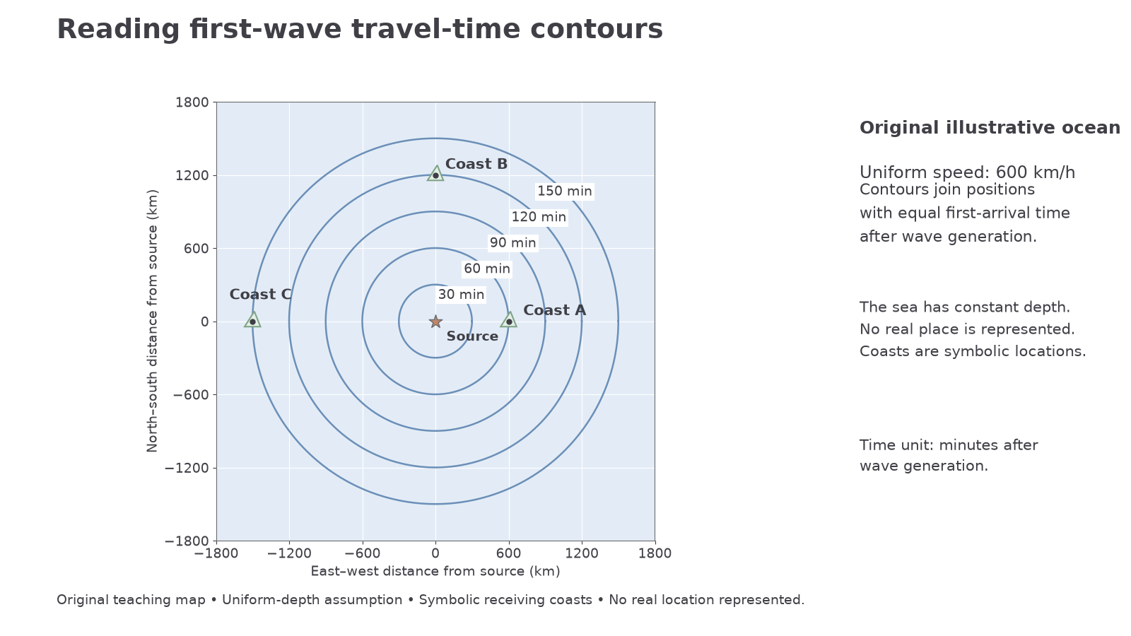
Original illustrative map. The source is at the centre, the assumed ocean speed is uniformly 600 km per hour, and contours show minutes after generation. This constant-depth model is designed to teach map reading and is not an operational forecast.
In this idealised map, Coast A lies on the 60-minute contour, B on the 120-minute contour and C on the 150-minute contour. If the wave is generated at 09:00, expected first arrivals are 10:00, 11:00 and 11:30. If a warning reaches A at 09:15, its gross warning window is 45 minutes. Verification, communication, evacuation travel and access needs reduce the usable window; some people may need to start moving immediately after strong or long local shaking.
For an idealised long wave, , where is speed in metres per second, is gravitational acceleration and is water depth in metres. With constant speed, , using compatible distance and speed units.
For example, at a depth of 4,000 m and using , , or 720 km per hour. A 1,440 km path at that speed takes 2 hours. This is a calculation under explicit assumptions, not the 600 km per hour assumed in the map.
Real oceans have variable depth. Tsunami energy travels faster through deeper water and slower over shelves, making actual isochrones irregular. Operational models use bathymetry and source estimates; buoys and coastal gauges help update forecasts. A travel-time map can prioritise warning communication and evacuation, but does not establish inundation height, the largest wave, or exact safe-return time. Errors in source location, generation time and depth data introduce uncertainty. A near-source coast may have very little warning, while a distant coast has more time but still needs an effective response.