1.2 - Plate tectonics and hazard characteristics
Learn how Earth's structure and heat transfer drive plate movement, how sea-floor evidence supports the theory, and why different margins produce different earthquakes and eruptions.
A layered Earth with moving lithosphere
Plate tectonics explains the movement of rigid lithosphere over a weaker part of the upper mantle, rather than the movement of crust alone. Two ways of describing Earth's layers must be kept separate: composition and mechanical behaviour.
By composition, Earth contains a thin crust, a much thicker silicate mantle, and an iron-rich core. Oceanic crust is relatively thin and basaltic; continental crust is thicker, less dense overall and more compositionally varied. The outer core is liquid, while the inner core is solid under immense pressure. Most of the mantle is solid rock.
By mechanical behaviour, the lithosphere combines crust with rigid uppermost mantle. Beneath it, the asthenosphere is hot, weak upper-mantle material that can deform and flow over geological time. A small amount of partial melt may occur, but describing the whole asthenosphere as liquid gives the wrong mechanism. A rigid plate can be supported by and move over solid rock that deforms slowly.
Heat remaining from Earth's formation and heat produced by radioactive decay contribute to internal energy. Temperature differences and gravity permit mantle convection: warmer, less dense material can rise, while cooler, denser material can sink. This circulation is slow and interacts with plates. It does not require each plate to sit on a neat, isolated circular conveyor belt.
Lithosphere and asthenosphere
The lithosphere is Earth's rigid outer layer, made of crust and uppermost mantle. The asthenosphere is a weaker, deformable part of the upper mantle beneath it.
Convection, ridge push and slab pull
Plate motion reflects a balance of driving and resisting forces within the plate–mantle system. Mantle convection provides the wider setting, but slab pull and ridge push explain important direct forces on plates.
At a spreading ridge, hot newly formed lithosphere is elevated. As it moves away it cools, thickens and becomes denser. Gravity causes lithosphere to move away from the elevated ridge, a force called ridge push. The name can mislead: magma does not simply act as a piston pushing two entire plates apart. It is mainly a gravitational effect associated with the sloping, cooling lithosphere.
At a subduction zone, cold oceanic lithosphere can become denser than the surrounding mantle. Its weight pulls the descending slab down and helps draw the attached plate towards the trench. This is slab pull, often a major driver where a long dense slab is present. Subduction also influences mantle flow. Friction on faults, bending of the plate and resistance from surrounding mantle oppose motion.
Sea-floor spreading is the creation and movement of oceanic lithosphere at a constructive margin. As plates separate, mantle rises; decreasing pressure promotes partial melting. Magma rises and solidifies to form new basaltic crust. Spreading is the observed movement and creation process; it should not be confused with a complete explanation of every force causing that movement. The relative importance of driving forces differs between plates and changes as boundaries develop.
Sea-floor ages and palaeomagnetism
Plate tectonic theory is tested by independent patterns rather than accepted solely because a diagram looks plausible. Ocean-floor age, magnetic properties, sediment thickness, earthquake locations and measured surface movement provide different kinds of evidence.
When basalt cools, magnetic minerals acquire a record of Earth's magnetic-field direction. Earth's magnetic polarity has reversed many times. Palaeomagnetism is the study of magnetic information preserved in rocks. At a spreading ridge, new basalt on both sides forms during the same polarity interval. Continued spreading carries it away, while younger basalt forms at the ridge. Alternating normal and reversed polarity strips can therefore form approximately symmetrical sequences on the two sides.
Radiometric dating shows that oceanic crust generally becomes older away from the ridge. Sediment cover also commonly thickens with age, although local deposition and erosion can complicate it. Together, age and magnetic patterns support sea-floor spreading. They are not evidence that the magnetic field pushes plates apart. Transform offsets and unequal spreading rates may disrupt perfect symmetry, so several observations should be combined.
A worked illustrative profile has 4-million-year-old basalt 120 km from a ridge axis. If it began at the ridge and travelled steadily perpendicular to it, the average half-spreading rate is 120 km divided by 4 million years: 30 km per million years, equivalent to 30 mm per year. If the opposite flank has the same rate, the full separation rate is 60 mm per year. One flank's distance must not be labelled the full spreading rate.
Use compatible units. per million years equals per year. Assume the crust formed at the ridge, measure perpendicular to the ridge and treat this as a long-term average rather than an instantaneous speed.
Recognising processes at four margins
A plate-boundary block diagram can be identified from the direction of motion, the kinds of lithosphere and the structures created at their contact. Begin with those features; a mountain or volcano alone is not enough to identify the margin.
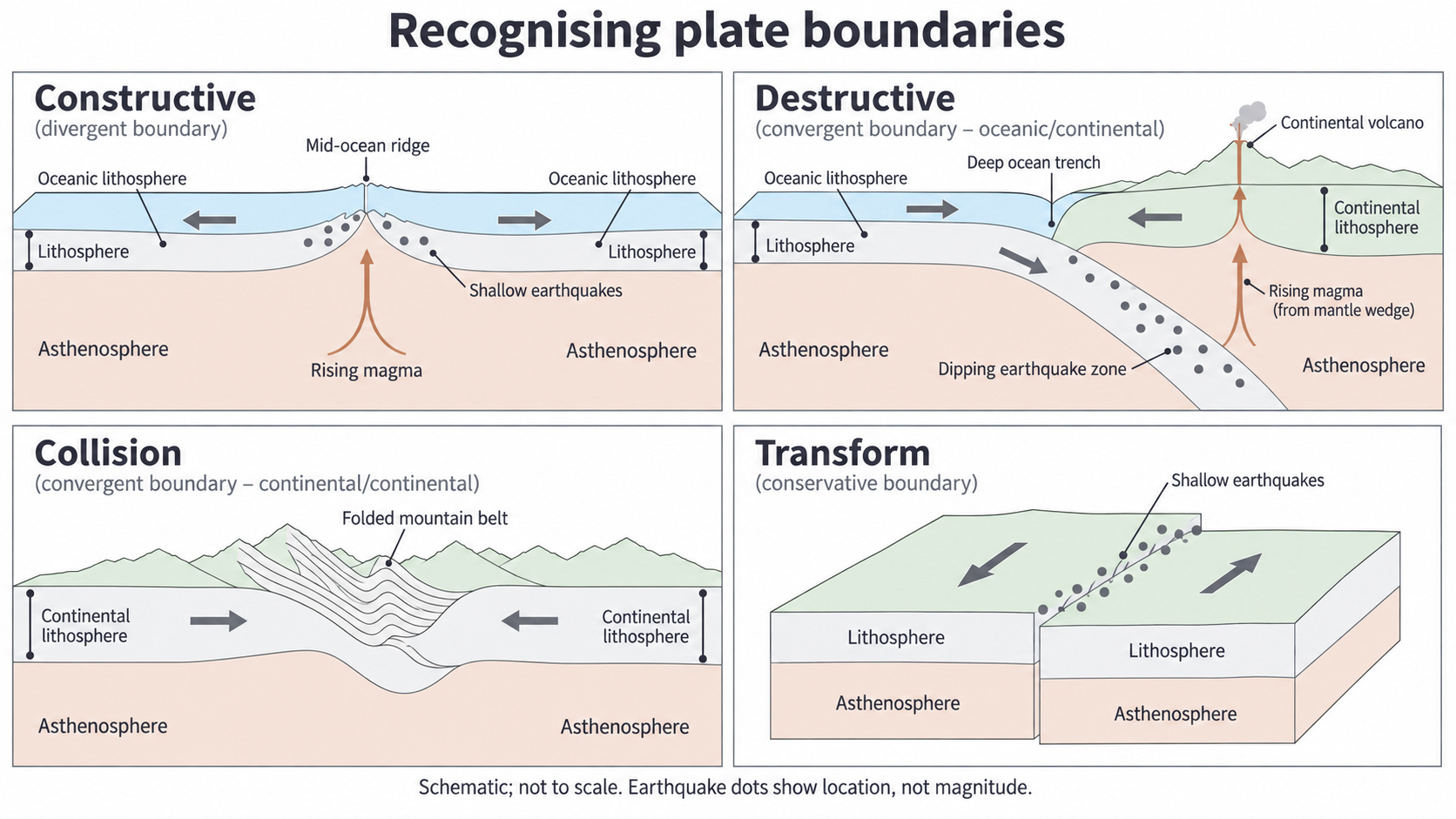
Original conceptual teaching diagram. Arrows indicate relative plate motion; earthquake dots indicate positions, not earthquake magnitude. Structures are schematic and not to scale.
At a constructive margin, plates diverge and rising mantle partially melts through decompression. New crust forms at a ridge or within a continental rift. Tensional faulting and magma movement generate mainly shallow earthquakes. No descending slab is present, so no deep inclined earthquake zone is expected.
At a destructive margin, dense oceanic lithosphere subducts. The descending slab releases fluids that lower the melting temperature of the mantle wedge above it. Partial melting there supplies magma that can rise into a volcanic arc. Do not say that friction simply melts the whole slab. Locking and sudden slip at the plate interface generate major earthquakes, and earthquakes also occur within the slab as it descends.
At a collision margin, two continental masses converge after intervening oceanic lithosphere has largely been consumed. Crust folds, faults, shortens and thickens to create high mountains. Thrust faults can produce damaging earthquakes. Buoyant continental lithosphere resists deep descent, and there is usually no active subduction volcanic arc at the collision front.
At a transform margin, plates slide laterally past one another. Faults can lock, allowing stress to accumulate before abrupt slip. Lithosphere is neither systematically created nor consumed, and volcanism is generally absent. Oceanic transforms connect displaced ridge segments; continental transforms such as the San Andreas system involve extensive fault networks. In a diagram, opposite arrows parallel to the fault distinguish transform motion from divergence across a gap.
Why earthquake depth and eruption style differ
A tectonic setting influences the type of hazard, but it does not determine the size or impact of every event. Physical characteristics vary within each setting.
An earthquake's focus is the place where rupture starts within the Earth; its depth is measured below the surface. Its magnitude measures source size using seismic information, whereas intensity describes effects and shaking at a particular place. A larger ruptured fault area, greater slip and stronger rock can produce a larger seismic moment and magnitude. Large locked subduction interfaces can rupture across long distances, producing the largest earthquakes. Shallow events also occur at constructive, transform and collision settings; shallow does not mean small.
The Wadati–Benioff zone is an inclined distribution of earthquake foci associated with a descending slab. Foci commonly become deeper inland from the trench, ranging from shallow through intermediate to deep events, sometimes reaching about 700 km. The cool slab retains conditions allowing earthquakes at depths where the surrounding hot mantle normally deforms without ordinary brittle failure. Deep earthquakes do not automatically cause the worst surface damage: distance from the source, local geology, rupture direction and buildings influence shaking. A long fault rupture means distance to the epicentre alone can be misleading.
Volcanic eruption style depends strongly on magma viscosity, dissolved gases and interaction with water. Hot, low-silica basaltic magma is relatively fluid, often allowing gas to escape and producing effusive lava flows. Higher-silica, cooler or crystal-rich magma is more viscous and can trap expanding gases; pressure release can fragment magma in an explosive eruption. Subduction settings often produce more evolved magmas through melting and crustal interactions. Constructive and oceanic hot-spot settings commonly supply basalt. These are tendencies: basalt can erupt explosively if gas release or water interaction favours fragmentation, as ice- or water-contact eruptions demonstrate.
Eruption magnitude also concerns how much material is erupted, not just whether the event is explosive. The volume of stored magma available, the rate at which it is supplied and how long eruption continues influence the total erupted volume. Gas pressure, magma viscosity and vent behaviour affect how rapidly material is fragmented and discharged. The Volcanic Explosivity Index (VEI) describes explosive eruptions using evidence such as ejecta volume and plume height; it should not be treated as an earthquake magnitude scale or as a complete measure of every lava-flow eruption. A long-lived effusive eruption can release a large lava volume, while a brief explosion may have a high plume but a different total volume. Style and magnitude therefore need separate evidence.
Boundary type explains a characteristic range of processes. Event magnitude, focal depth and eruption style require additional evidence about the fault, slab and magma; they cannot be read from the boundary name alone.