1.1 - Tectonic hazards and plate boundaries
Learn why earthquakes, volcanoes and tsunamis form distinctive geographical patterns, how those patterns relate to plate movements, and why hazards also occur within plates.
Reading global and regional hazard patterns
Tectonic hazards cluster because the Earth's rigid outer shell is divided into moving plates rather than behaving as one unbroken surface. A tectonic plate contains crust and the rigid uppermost mantle: together these form the lithosphere. Plate edges are broad zones of interaction in some regions, not perfectly thin lines.
Earthquakes occur when stressed rock ruptures or faults slip suddenly, releasing stored elastic energy. Many form narrow belts along plate boundaries. Globally, major earthquake belts surround the Pacific and extend through the Mediterranean–Himalayan region. Earthquakes also occur at ocean spreading ridges, although a map showing only large events underrepresents their many smaller earthquakes. Volcanoes cluster around much of the Pacific and along spreading ridges; their distribution overlaps earthquake belts without matching them everywhere. Continental collision and transform boundaries generate earthquakes but usually no active volcanic chain.
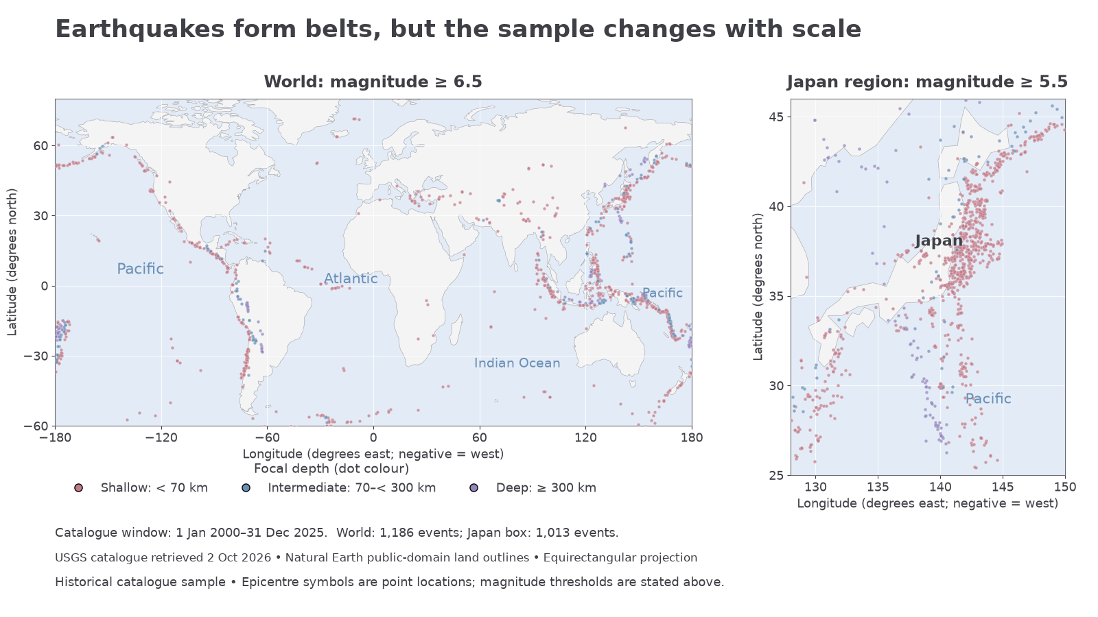
The world panel shows catalogue events of magnitude at least 6.5; the Japan panel uses at least 5.5. Positions are authentic USGS catalogue coordinates downloaded on 2 October 2026. Land outlines are public-domain Natural Earth data. This is a historical event sample, not a forecast; the panels have different thresholds.
Read a hazard map in three steps. First check its extent, date range, key and selection threshold. Next describe the spatial pattern with directions and named regions: for example, the Japan panel resolves a concentrated belt near the Pacific side of the islands that is difficult to distinguish on the world map. Finally explain it using a tectonic setting and identify an exception. The Pacific Ocean appears split at the edges of this world projection; clusters on its two sides belong to the same ocean-margin system.
Changing scale reveals different evidence. A world map establishes broad clustering; a regional map shows whether epicentres lie inland, offshore or in several parallel belts. Coloured depth symbols can reveal a landward-deepening earthquake zone near Japan. A point symbol marks an epicentre, the surface location above an earthquake's origin; it does not show the size of the rupture or the area shaken. Dense points may overlap. A blank area means no selected event in that period, not zero future hazard.
Plate movements and boundary settings
A boundary's hazard pattern depends on the relative motion of the adjoining plates and on whether their edges carry oceanic or continental lithosphere. A plate may carry both; a coastline is therefore not automatically a plate boundary.
| Relative motion | Setting and distribution | Expected hazard pattern |
|---|---|---|
| Divergent: plates move apart | Oceanic spreading ridges, such as the Mid-Atlantic Ridge; continental rifts, such as the East African Rift | Shallow earthquakes and volcanic activity as mantle material rises and partially melts |
| Convergent: plates move together | Oceanic–continental subduction along the Andes; oceanic–oceanic subduction in island arcs such as the Mariana arc | Earthquakes at a range of depths, volcanic arcs and potential earthquake-generated tsunamis |
| Convergent: continental collision | The India–Eurasia collision forming the Himalayas | Major earthquakes and mountain building; usually no subduction-related volcanic arc |
| Conservative: plates slide past | Transform faults such as the San Andreas system in California; transforms also offset spreading-ridge segments | Mainly shallow earthquakes; neither systematic creation nor destruction of lithosphere and usually no volcanism |
Subduction occurs when dense oceanic lithosphere descends beneath another plate. This explains why a volcanic arc can lie inland or landward of an ocean trench rather than exactly on the surface plate boundary. Continental lithosphere is relatively buoyant, so a continent–continent collision mainly shortens and thickens the crust. These general settings explain regional patterns; plate boundaries can include oblique motion, several faults and transitions between boundary types.
At a world scale, the Mid-Atlantic Ridge helps explain a long volcanic belt within an ocean. At a regional scale, Iceland is an exposed section of this spreading system, influenced additionally by a hot spot. In the Andes, the Nazca plate descends beneath the South American plate; earthquakes and a volcanic chain therefore occur near the continental margin. In the Himalayas, convergence occurs without the same oceanic-subduction volcanic arc. Compare the process, not simply whether an area is near a mountain or a coast.
Tsunami sources and exposed coasts
A tsunami's source distribution and its impact distribution are different. A tsunami is a sequence of long waves generated by rapid displacement of a large water volume. Large, shallow submarine earthquakes at subduction zones can move the seabed vertically and displace the water above it. Consequently, many tsunami sources lie around the Pacific and along the Sunda subduction zone bordering the Indian Ocean.
An offshore earthquake does not automatically create a major tsunami. A deep rupture may produce little seabed displacement; a mainly horizontal strike-slip movement usually displaces much less water than a large vertical movement. Submarine landslides, volcanic activity and other sudden displacements can also generate tsunamis. Earthquake size, depth, fault movement and rupture location all matter.
Once generated, tsunami energy can cross an ocean. A coast far from a plate boundary can therefore be exposed to a distant-source tsunami. Local seabed depth, coastline shape and low-lying coastal land affect how the wave develops and where flooding occurs. A world map of tsunami damage should not be interpreted as a map of earthquake epicentres. The 2011 Japan and 2004 Indian Ocean tsunamis illustrate the connection between an ocean-margin source and effects across a wider basin; travel time and coastal conditions help explain the differences.
Earthquake and volcanic source patterns mainly follow tectonic settings. Tsunami exposure also depends on the pathway from a water-displacement source to a receiving coast.
Hazards away from plate boundaries
A plate interior can contain faults and volcanic centres even where it lies far from a present plate boundary. Intra-plate earthquakes can occur when stresses transmitted through a plate reactivate an older fault. Ancient rifts and other weaknesses may concentrate that stress. Human activities, such as some fluid injection or reservoir loading, can also change fault stresses, but not every intra-plate earthquake is human induced.
A hot spot is a long-lived focus of volcanic activity that can occur within a plate. In the mantle-plume explanation, unusually hot mantle rises from depth. As it rises, pressure decreases and some mantle partially melts. Magma can then reach the surface. The mantle remains predominantly solid; it is not a liquid sea beneath the crust.
If a plate moves over a relatively persistent plume, the active volcanic centre can remain over the plume while older volcanoes are carried away. A chain with systematically older volcanic rocks away from its active end provides evidence of plate movement. The Hawaiian island chain is a key oceanic example. A continental hot spot, such as Yellowstone, can involve interactions with continental crust and produce very different eruptive materials. A hot spot is not necessarily evidence of a new plate boundary.
The plume model is useful but simplified: plume behaviour, shallow mantle flow and the movement of hot spots remain research questions. Iceland shows why explanations can overlap: it lies on a divergent boundary and is influenced by a hot spot. An apparent exception to a boundary pattern should prompt an additional process explanation, not abandonment of plate tectonics.