2B.2 - Geological structure and coastal form
Learn how the orientation and weaknesses of rock layers influence coastline shape, cliff profiles and local erosion, from headlands and bays to caves.
Rock bands beside or across the coast
The orientation of rock bands determines which materials waves encounter along a coastline.
Concordant and discordant coasts
On a concordant coast, rock bands run broadly parallel to the coastline. On a discordant coast, contrasting rock bands meet the coastline at an angle, commonly close to a right angle.
On a discordant coast, alternating resistant and less resistant rocks are exposed to the sea side by side. Weaker bands retreat more rapidly into bays, while more resistant bands remain as headlands. As this relief develops, wave refraction concentrates energy around projecting headlands and spreads it through bays. Sediment accumulating in sheltered bays may protect the weaker rock. Differential resistance creates the initial contrast; changing wave energy and beach cover can reinforce or modify it.
On a concordant coast, a resistant outer band can protect weaker rock behind it. If a fault or joint is breached, waves gain access to that weaker band. Rapid lateral erosion can widen a cove behind a narrow entrance; another resistant band inland may limit its landward growth. Concordance does not guarantee a straight coast, and a cove is not just a bay with a different name: its restricted entrance and widening behind a protective band reveal a particular structural control.
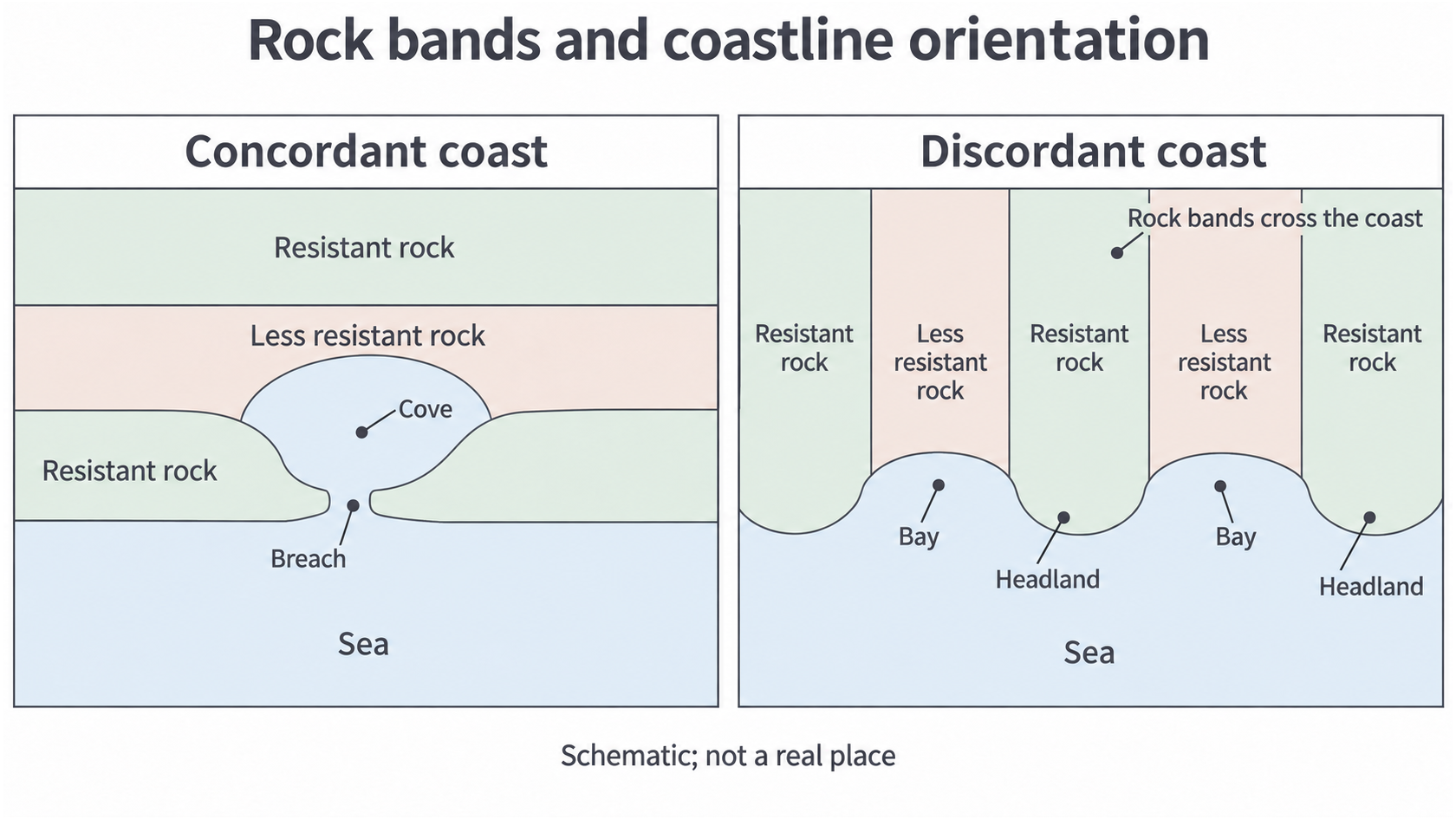
Schematic plan views: an outer band can shield a concordant coast; differential erosion creates headlands and bays on a discordant coast.
Parallel coastlines can have different origins
Long narrow coastal features can look similar in plan view even when different processes created them.
A Dalmatian coast develops where a rise in relative sea level submerges a landscape whose ridges and valleys run parallel to the coast. Lower valleys become long marine channels; higher ridges remain as elongated islands. The name refers to the Adriatic coast of Croatia. Folding and the structural grain organise the original ridges, while inundation converts terrestrial relief into islands and waterways. Present waves then modify these inherited forms; waves did not build the islands from beach sediment. A 2012 geomorphological study of Ugljan documents the link between structural alignment and late Quaternary marine inundation.
A Haff-type coast contains elongated lagoons separated from the sea by broadly shore-parallel sandy barriers, exemplified around parts of the southern Baltic such as the Curonian Spit and Lagoon. On a shallow low-relief coast, waves and alongshore transport redistribute sediment into barriers, restricting exchange between lagoon and open sea. Its parallel layout places it among concordant coastal forms, but do not assume a resistant bedrock wall creates every Haff barrier. Sedimentary inheritance, relative sea-level history and deposition are necessary parts of its explanation.
When interpreting satellite images, a chain of long rocky islands with intervening flooded channels suggests a Dalmatian landscape. A continuous narrow sandy barrier enclosing a shallow lagoon suggests Haff morphology. Check geology and elevation: sediment barriers and bedrock ridges can be hard to distinguish from shape alone. The classification names a pattern; the explanation must identify how that pattern formed.
Weaknesses and dip shape cliffs and caves
Geological structure controls where water enters rock and which blocks can move, even within a single rock type.
Bedding planes separate sedimentary layers. Joints are fractures without substantial displacement; they let water and pressurised air penetrate and divide rock into blocks. A fault is a fracture along which displacement has occurred, often accompanied by fractured rock. Folding bends layers and changes their exposure and inclination. Dip is the angle at which a layer slopes from the horizontal, together with its direction.
Closely spaced joints provide more accessible weaknesses, encouraging fragmentation and local cave enlargement. Widely spaced joints can leave larger coherent blocks, although their eventual collapse may be substantial. Waves repeatedly compress water and trapped air in a joint; weathering also weakens its sides. A fault zone can be eroded faster than adjacent intact rock, focusing an inlet or cave. Not every cave follows a fault: a bedding-plane weakness or a particularly erodible bed may be enough.
Horizontal resistant layers can support steep, stepped cliffs where weaker beds beneath are removed. Seaward-dipping beds can form inclined sliding surfaces where they emerge in the cliff face: a block may slide if gravity overcomes resistance along a weakened bedding plane. Landward dip can reduce this particular sliding route because the beds slope into the cliff, but joint-controlled falls and undercutting remain possible. Dip direction is an influence on stability, not a guarantee of safety.
The Glamorgan Heritage Coast supplies a located example of layered and fractured geology. BGS describes the Lower Jurassic cliff succession as interbedded limestone and mudstone, with folding and faulting visible around Southerndown. Different resistance between beds can create ledges and recesses; bedding planes, joints and faults provide routes for erosion. Use a geological map and a photographed cliff section together to distinguish regional structure from individual weaknesses. A general rock name cannot explain every cave or cliff profile along the reach.
Lithology describes the material; structure describes its arrangement and weaknesses. A strong rock can erode rapidly where it is intensely fractured or exposed along unstable planes.