2A.2 - The cryosphere and changing ice cover
Learn to classify ice masses, explain their role in Earth systems, and compare modern ice cover with the evidence left by much more extensive Pleistocene glaciation.
Frozen water in Earth systems
The cryosphere connects climate, water storage, oceans and ecosystems because frozen water can persist, reflect energy and later melt.
Cryosphere
The parts of Earth where water is frozen, including snow cover, glaciers, ice sheets, sea ice, lake and river ice, and frozen ground such as permafrost.
Large land-ice masses store freshwater for centuries to millennia. Their melt supplies rivers and transfers water to the ocean. Loss of grounded land ice adds water to the ocean and raises global mean sea level. Floating sea ice already displaces water, so its melting has little direct effect on sea level; its disappearance still matters greatly for energy balance and ecosystems. Floating ice shelves can restrain grounded ice behind them, so losing a shelf can indirectly increase sea-level rise by accelerating that grounded ice.
Snow and ice have relatively high albedo, the fraction of incoming solar energy reflected. Replacing them with darker rock, water or bare ice usually increases absorbed energy and reinforces warming. Seasonal snowmelt changes the timing of river flows. Permafrost influences infiltration and soil drainage; thaw changes ground stability and can permit stored organic carbon to decompose. These are connections between cryosphere, hydrosphere, atmosphere, lithosphere and biosphere, not isolated consequences.
Distinguish an ice-covered surface from a glaciated landscape. A landscape may contain landforms produced by former glaciers while having no glacier today. Britain has extensive glaciated landscapes, but no surviving permanent glacier.
Classifying ice masses and thermal conditions
Ice masses differ in size and topographic control, while their thermal condition controls how they interact with their beds.
A glacier is a persistent body of land ice formed largely from accumulated snow and moving under its own weight. Snow cover that melts where it falls without forming flowing ice is not a glacier.
| Ice mass | Distinguishing characteristics | Example location |
|---|---|---|
| Ice sheet | More than 50,000 square kilometres; buries much underlying relief and flows broadly outward from interior high areas | Greenland and Antarctica |
| Ice cap | Smaller than an ice sheet; dome-like mass that covers underlying relief and feeds outward flow | Vatnajökull, Iceland |
| Ice field | Connected ice across mountain terrain; rock peaks may protrude and topography strongly guides flow | Juneau Icefield, Alaska and British Columbia |
| Cirque glacier | Small glacier occupying a mountain bowl near a valley head | High mountain ranges including the Alps |
| Valley glacier | Elongated ice flowing along a valley, often fed from a cirque, cap or field | Alpine and Himalayan valleys |
These categories describe form and scale, not a sequence in which every glacier must develop. An ice sheet may feed narrow outlet glaciers, and a valley glacier can reach the sea. Ice shelves are floating extensions of land ice; they are different from sea ice formed by freezing seawater.
In a temperate glacier, ice is close to its local pressure-melting point for much of its thickness, so basal water and sliding can occur. In a polar glacier, much ice remains below that melting point and substantial bed areas may be frozen, restricting sliding. A polythermal glacier contains both warm and cold zones. Location is a useful clue, not a perfect classification: thick polar ice sheets can contain warm-based fast-flowing sectors. “Polar” does not mean “motionless”, and mountain glaciers are not all temperate.
Why latitude and altitude matter
Glaciers survive where accumulation exceeds loss sufficiently often, so both cold conditions and a supply of snow are needed.
The only present ice sheets cover Greenland and Antarctica at high latitudes. Reduced solar input, long cold seasons and persistent snow enable broad ice cover, although very dry interiors accumulate slowly. High latitude alone is not enough: precipitation, ocean influence and topography explain contrasts within the Arctic.
Mountain glaciers occur in Alaska, western Canada, the Andes, the European Alps, the Himalaya–Karakoram and New Zealand's Southern Alps, among other ranges. High altitude lowers air temperature. Mountains also force moist air upwards, producing snowfall on favourable slopes. Near the equator, permanent glaciers can occur at very high elevations; towards the poles, ice can survive much nearer sea level. Latitude and altitude therefore partly compensate for one another.
Aspect, shading, wind redistribution and avalanche supply introduce local differences. A shaded cirque may retain snow while a nearby exposed slope at the same elevation does not. A snowy maritime mountain may support larger glaciers than a colder but dry inland range. A map of ice cover needs temperature and precipitation explanations, not the rule “the coldest place has the most ice”.
High latitude permits broad low-elevation ice cover. At lower latitudes, sufficiently high and snowy mountains can support ice, with aspect and precipitation modifying the pattern.
Reconstructing former ice extent
Past ice cover must be reconstructed from converging evidence because the ice itself has usually disappeared.
During Pleistocene glacials, the Laurentide Ice Sheet occupied much of Canada and extended into the northern United States. Large ice sheets covered Scandinavia and parts of northern Europe. British–Irish ice covered much of Britain and Ireland during major cold phases. Today's ice sheets are concentrated in Greenland and Antarctica, while these former Northern Hemisphere ice-sheet regions retain extensive relict landscapes and smaller mountain or Arctic ice masses.
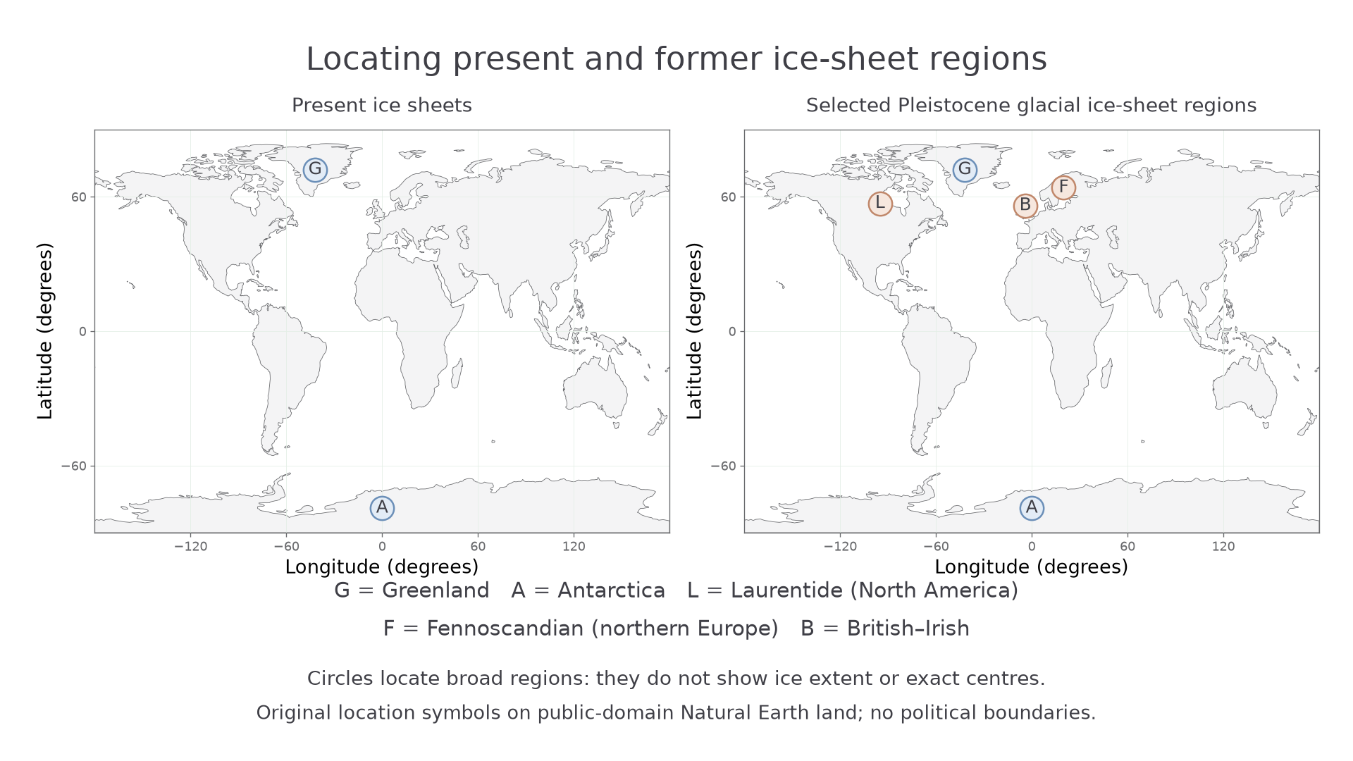
Original location symbols on public-domain Natural Earth land polygons. Circles identify broad regions, not ice-sheet boundaries; their sizes do not measure area. Selected Pleistocene regions summarise major glacials rather than one synchronous dated maximum.
The maps show that major Northern Hemisphere ice-sheet regions were more numerous and extended into lower-latitude North America and Europe. The high-latitude Greenland and Antarctic regions persist. The longitude–latitude grid permits location comparisons, but this projection distorts areas near the poles. Do not calculate ice loss from the circles: an extent comparison requires dated boundary polygons rather than region symbols.
In Britain, the Anglian ice limit extended much farther into southern and eastern England than the last major Devensian ice sheet. Till in East Anglia and its stratigraphic relationships therefore do not imply that the last glaciation covered every place reached by older ice. In upland areas such as the Lake District and Snowdonia, cirques and glacial troughs remain after the disappearance of glaciers. The Alps offer a contrast: active high-altitude glaciers coexist with lower valleys shaped by much larger Pleistocene ice systems.
Evidence includes till, deposited directly by ice; erratic boulders transported from a different rock source; striated bedrock; moraines marking margins; and streamlined or eroded terrain indicating flow. A single erratic may have been reworked, and absence of till may reflect later removal. Landforms plus sediment, dating and rock provenance give a stronger reconstruction than one isolated feature.
To compare two maps, first check their dates, projections, scale and legends. Separate actual glacier polygons from “formerly glaciated” shading. Describe change in extent, latitude and elevation; then identify surviving and disappeared ice centres. At regional scale, use the same boundary for both dates. An original illustrative comparison for a fixed mountain catchment gives 60 square kilometres of ice at a dated former maximum and 12 square kilometres in a modern survey: a decline of . This measures mapped area, not volume lost, and depends on the reliability of the reconstructed boundary.
GIS can overlay glacier outlines, elevation and geological evidence. Align coordinate systems, use comparable survey seasons, and distinguish seasonal snow from ice. Repeat imagery should be taken near the end of the melt season where possible. Debris-covered ice can be difficult to classify, so a clean white patch is not the only possible glacier surface.