2A.7 - Glacial erosion and landforms
Learn how moving ice, weathering and geology create landforms, and how maps and ranked observations can test an explanation of a glaciated landscape.
Erosion at the glacier bed
A glacier erodes through contact between moving ice, its debris and the rock beneath it; ice alone is not a universal cutting tool.
Abrasion
The scraping and grinding of bedrock by rock fragments carried at the base of moving ice.
Debris pressed against the bed scratches striations and can polish rock. Fine debris grinds the surface; large clasts cut deeper grooves. Erosion depends on sliding speed, pressure, debris supply and rock resistance. Too little debris provides few tools, while a thick loose sediment layer may shield the bed. Crushing breaks fragments or weak bedrock under concentrated stresses, supplying smaller abrasive particles and rock flour.
Quarrying, often called plucking, removes blocks from jointed bedrock. Ice flows over an obstacle and pressure changes around it. Water enters joints; freezing can attach blocks to ice, while variations in water pressure and stresses help loosen them. Sliding ice then entrains the blocks. These are overlapping terms for block removal, rather than two completely separate landform recipes.
Basal melting occurs where the bed reaches the pressure-melting point and heat is available, including frictional and geothermal heat. Pressure changes around small obstacles can enable melting and refreezing. Meltwater can lubricate sliding and alter joint-water pressure, influencing abrasion and quarrying. Melting is therefore part of the erosional system; it does not mean that ice melts solid bedrock away. Cold-based ice frozen to its bed normally does much less sliding erosion.
Above the ice, water freezing in cracks contributes to freeze–thaw weathering where moisture and suitable temperature changes occur. Rockfalls and other mass movements remove loosened material from steep walls and feed debris onto the glacier. Glacial erosion undercuts and steepens walls, encouraging further failure. A landform thus records interacting subglacial and subaerial processes.
Cirques, arêtes and pyramidal peaks
A cirque develops where snow and ice persist in an upland hollow and erosion enlarges the hollow into a steep-sided basin.
Initially, shaded or snow-catching hollows favour accumulation. Nivation and weathering help enlarge a hollow, but a substantial cirque or corrie requires glacial erosion. Thickening ice moves rotationally within the bowl. Abrasion and quarrying deepen the basin, while freeze–thaw and rockfall help the backwall retreat. Ice is generally thinner near the outlet, so less erosion there can leave a raised rock lip. After deglaciation a tarn may occupy the overdeepened basin, sometimes assisted by a moraine dam.
Where adjacent cirques erode backwards towards each other, the intervening divide narrows into an arête, a sharp ridge. Erosion by cirques on several sides can leave a pyramidal peak where the ridges meet. These landforms develop over repeated glaciations and also reflect the original relief and structure of the rock. A north-facing aspect often favours snow survival in the Northern Hemisphere through lower solar exposure, but wind redistribution, altitude and snowfall can outweigh aspect. Reverse the shading expectation in the Southern Hemisphere; do not treat compass direction as a universal cause.
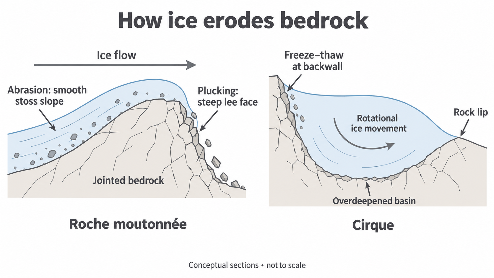
The sections are conceptual and not to scale. The cirque's basin is deepened beneath thick ice; the lip is not a pile of ice pushed forward.
The valley landform assemblage
Valley glaciers reshape an existing drainage network unevenly, so related features should be explained together.
Ice fills much of a river valley's cross-section. Abrasion and quarrying deepen the floor and widen the sides, producing a steep-sided glacial trough, often with a broad U-shaped profile. The glacier removes projecting interlocking spurs, leaving abrupt truncated spurs. The trough is not made simply by pushing the sides apart: rock is removed and exported.
A main glacier usually carries more ice and has greater erosive power than a tributary. Its valley can be deepened much more, leaving the tributary floor perched above it as a hanging valley. A postglacial stream may fall as a waterfall into the main trough. Geology, ice duration and confluences complicate this contrast, so ice thickness is an explanation to investigate rather than a rule that every tributary must follow.
Long ribbon lakes occupy overdeepened sections of troughs. Thicker ice, a confluence or less resistant rock can concentrate erosion, while a bedrock threshold or later moraine may impede drainage at the outlet. Water then fills the basin after retreat. Sediment infilling and postglacial river incision can modify these features. On an OS map, steep closely spaced valley-side contours, a broad floor, straightened spur ends and a high tributary outlet support a glacial interpretation; any one feature alone is weaker evidence.
Ice-sheet scouring and differential geology
Ice sheets can scour broad areas, but the pattern of erosion varies with joints, rock strength and the direction of ice movement.
A roche moutonnée is a bedrock mound with an abraded, relatively smooth, gently sloping upstream stoss face and a rougher, steeper downstream lee face where quarrying removes blocks. Read both the surface texture and slope asymmetry before inferring flow from stoss to lee. The left panel of the diagram shows this contrast. Striations support an axis of movement but do not by themselves distinguish the two possible directions along it.
In a knock and lochan landscape, resistant rock survives as low hills or knolls, while weaker or strongly jointed zones are scoured into hollows that fill with water. Ice-sheet erosion and differential geology therefore create a mosaic of rock and lakes, rather than a uniform flat surface. BGS describes scoured rock, corries and drift in the Northern Highlands of Scotland: a UK example of how an assemblage records both erosion and deposition.
A crag and tail forms where a resistant crag obstructs ice flow. The crag protects material downstream from stronger erosion, leaving a tapering tail which may contain less resistant bedrock and/or deposited till. Its tail normally points down-ice. Unlike a roche moutonnée's plucked lee face, this feature has sheltered material extending behind the obstacle. Bedrock mapping helps explain why one outcrop survived and neighbouring rock did not.
A landform's shape is evidence of process filtered through geology. Combine morphology, surface textures and mapped rock types before reconstructing ice flow.
Cirque orientation and ranked relationships
Mapped measurements can test whether cirques are associated with altitude and favourable orientation, provided the variables are defined consistently.
On a large-scale OS map, identify the basin, backwall and outlet using contours; draw the basin's outward-facing axis from backwall towards lip and record its bearing clockwise from north. Use the same basin-height definition, such as the lowest closed basin contour, for every site. Estimate plan area from a mapped polygon with a scale or GIS, in square kilometres. A satellite image helps verify the feature, but distinguish ice-covered active basins from exposed relict ones. Equivalent topographic maps and GIS allow comparison outside the UK.
Compass bearings are circular: 359° and 1° are close, although a raw ranking would separate them. For a hypothesis about north-facing shade, transform aspect to northness, , where is the bearing and the calculator is in degrees. Northness is +1 for north, 0 for east/west and −1 for south. It is dimensionless and tests one specified shading relationship; it is not a complete description of orientation.
This original illustrative dataset is not field evidence from a real range:
| Basin | Height (m) | Area (km²) | Aspect (°) | Height rank | Area rank |
|---|---|---|---|---|---|
| A | 550 | 0.06 | 180 | 1 | 1 |
| B | 600 | 0.08 | 160 | 2 | 2 |
| C | 650 | 0.09 | 140 | 3 | 3 |
| D | 700 | 0.10 | 120 | 4 | 4 |
| E | 750 | 0.12 | 100 | 5 | 6 |
| F | 800 | 0.11 | 80 | 6 | 5 |
| G | 850 | 0.14 | 60 | 7 | 8 |
| H | 900 | 0.13 | 40 | 8 | 7 |
| I | 950 | 0.16 | 20 | 9 | 9 |
| J | 1000 | 0.18 | 0 | 10 | 10 |
For paired ranks without ties, Spearman's coefficient is
where is the difference between the two ranks and is the number of paired observations. Rank both variables in the same direction. For ties use average ranks and a method that handles ties appropriately.
Here four rows have a rank difference of magnitude 1, so and to three decimal places. This is a strong positive height–area association. Against a supplied two-tailed 5% critical value of 0.648 for ten pairs, its magnitude exceeds the threshold: reject the null hypothesis of no monotonic association. This does not give a 95% probability that height caused basin size.
Northness increases in the same order as height here, so northness–area also has . The two explanatory variables are confounded: this sample cannot distinguish greater snow survival at north-facing sites from an altitude effect. Examine a scatter plot, add sites covering different combinations of height and aspect, consider lithology and avoid sampling neighbouring basins as if fully independent. Repeat measurements or mapping at a second range can test transferability. A significant association supports an enquiry; it does not prove a single formation process.