3.1 - Tropical cyclone formation and measurement
Tropical cyclones draw energy from warm oceans but need several conditions to organise into powerful rotating storms. Explain their formation, distribution and structure, then interpret wind and pressure measurements carefully.
Conditions for cyclone formation
A tropical cyclone is an organised rotating low-pressure system with thunderstorms that develops over tropical or subtropical water. “Hurricane” and “typhoon” are regional names for strong tropical cyclones, not separate physical mechanisms.
Warm ocean water, commonly about 26.5°C or warmer through a sufficient depth, provides heat and moisture. Evaporation supplies water vapour; rising moist air cools and condenses, releasing latent heat that supports further uplift. Warm surface water alone is not sufficient: a shallow warm layer can be mixed with colder water, weakening the energy supply.
An existing disturbance helps air converge and rise. Low atmospheric pressure encourages surface inflow, while rising air and removal of air aloft help maintain the circulation. A moist, unstable atmosphere supports deep convection. A cyclone does not form because a patch of sea simply becomes hot enough to boil.
The Coriolis effect, associated with Earth's rotation, deflects moving air and supports organised rotation. It is weak near the equator, so development is uncommon within roughly 5° of it. Coriolis shapes the circulation; the warm ocean supplies energy. Low vertical wind shear, a small change of wind with height, helps thunderstorms remain organised around the centre. Strong shear can tilt or disrupt the system.
Eye, eyewall and circulating air
In a mature cyclone, air converges near the surface and spirals around the low-pressure centre. The eyewall contains strong uplift, intense rain and often the strongest winds. In the eye, air generally descends and conditions may be temporarily calmer. Pressure remains very low there; a calm interval during eye passage does not mean the storm has ended.
High-level outflow carries air away from the top of the system. Rainbands extend beyond the eyewall, so dangerous conditions can occur far from the centre. Northern-hemisphere storms rotate anticlockwise and southern-hemisphere storms clockwise, viewed from above; the cross section below shows vertical flow rather than that plan-view rotation.
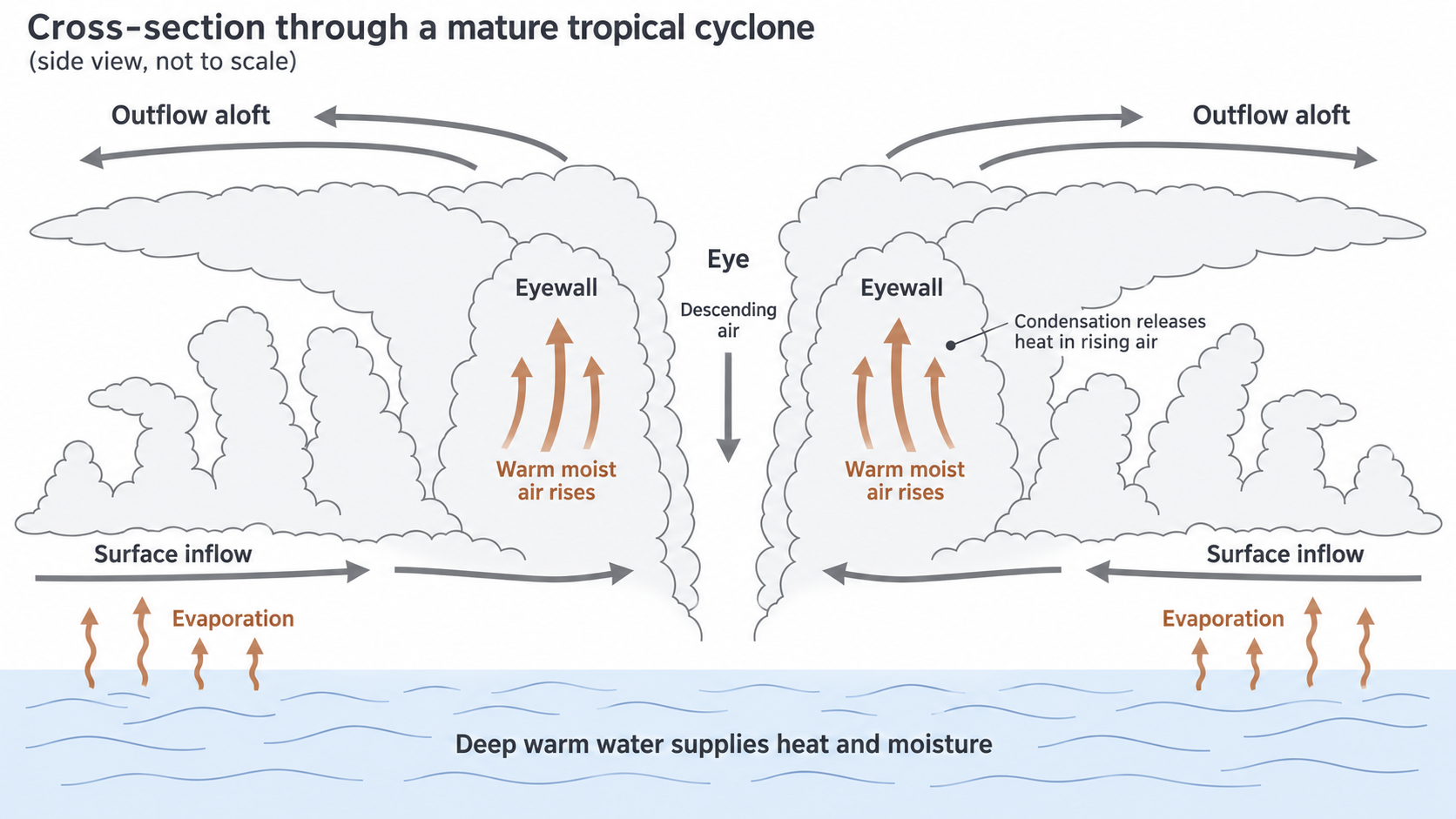
A schematic vertical slice, not a forecast or a diagram of wind direction viewed from above.
As a cyclone moves over land, it loses its continuous warm-ocean moisture and heat supply, and surface friction also disrupts circulation. Cooler water, dry air or strong wind shear can weaken it at sea. Weakening winds do not immediately end heavy rain, river flooding or landslide risk.
Continue this lesson.
You’re previewing NovaLearn without an account. Create a free account to read the rest.
Create free account