1.1 - Water cycle and drainage basins
Water moves between oceans, air, land and living things without leaving the Earth's water system. Learn how the global cycle differs from a drainage basin, and how a map reveals the route water takes to a river mouth.
Global stores and transfers
The hydrological cycle is the continuous movement of water between stores. A store holds water for some time; a transfer moves it. Oceans are the largest store. Ice sheets and glaciers, groundwater, lakes, rivers, soil, vegetation and the atmosphere also hold water. The time spent in a store varies enormously: a drop may cross a small river reach quickly but remain in an ice sheet for centuries.
Closed system
A system that exchanges energy with its surroundings but, at the scale being studied, has no significant net exchange of matter.
The global hydrological cycle is treated as a closed system: solar energy enters and heat leaves, but its water is recycled rather than continually supplied from outside Earth. This does not mean every store stays the same size. Melting land ice transfers water to the ocean; the total remains within the system.
Solar energy supports evaporation, the change of liquid water into water vapour. Plants take up water and release vapour through transpiration. Together these are evapotranspiration. Cooling air can cause vapour to condense into tiny liquid droplets or ice crystals. Clouds form, and water returns as precipitation, such as rain or snow. Wind transports moisture between places, so evaporation over an ocean can eventually supply rainfall on land.
Water moving through land
Rain does not all reach a river immediately. Interception occurs when leaves and branches catch precipitation. Some intercepted water evaporates; some drips to the ground. Water can collect in puddles or enter the soil by infiltration. It may move sideways through soil as throughflow, or downward into rock by percolation. Groundwater occupies saturated pores and cracks below the water table and can flow slowly towards a channel.
When rainfall arrives faster than the ground can absorb it, water flows across the surface as surface runoff. Runoff also develops when the ground is already saturated. These routes have different speeds: a paved road can deliver water rapidly to a drain, whereas water moving through soil and rock is usually delayed. That difference will matter when explaining floods.
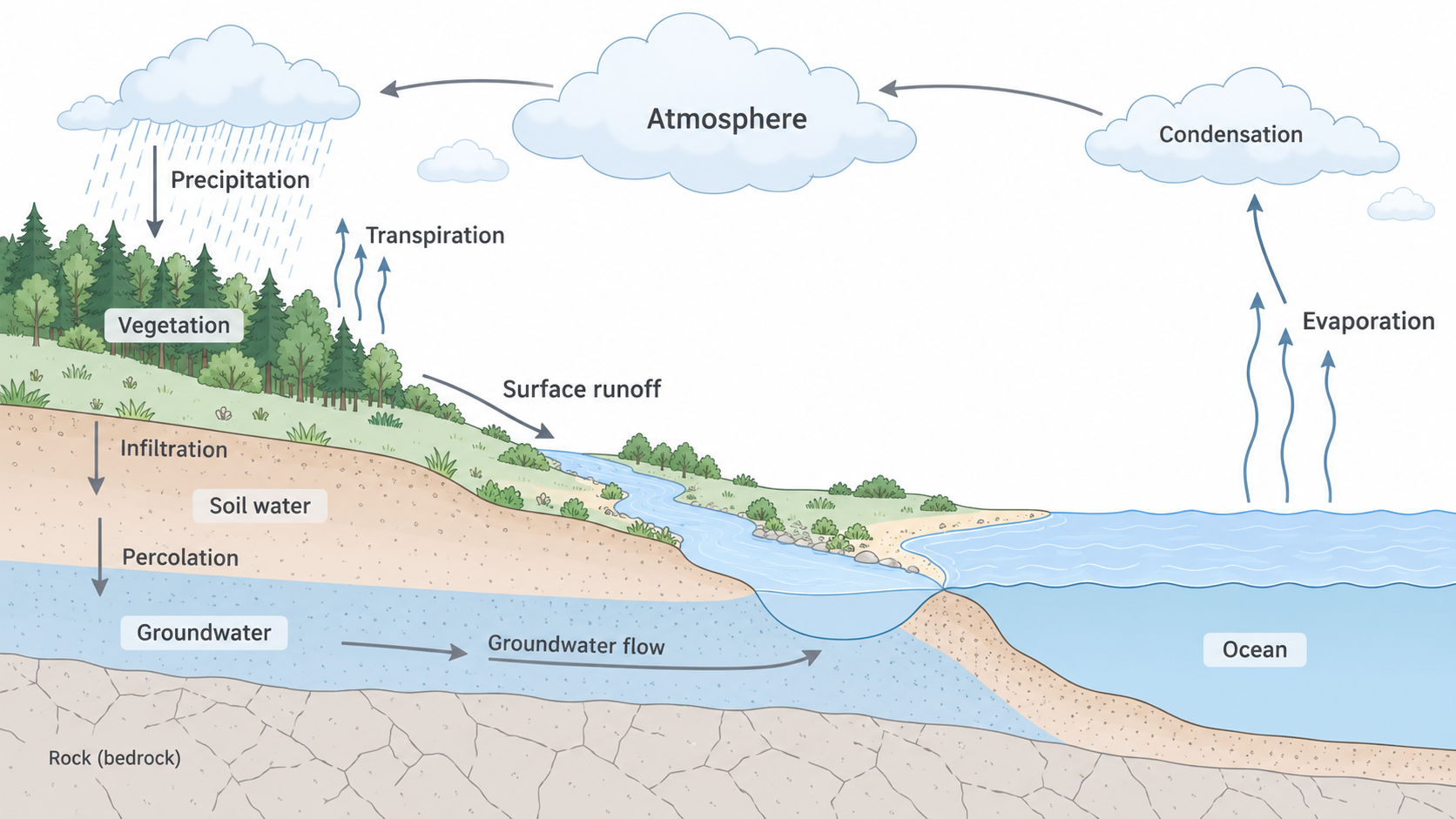
The global water cycle and selected land transfers. This is a schematic: groundwater also moves through permeable rock, not only a single layer, and not every possible transfer is shown.
The drainage-basin network
A drainage basin is the land area drained by a river and its tributaries. Its boundary, the watershed, usually follows high land separating flow towards neighbouring river systems. A watershed is a boundary, not another channel. The river begins at its source, which may be a spring, lake, glacier or upland area where small flows join. A tributary joins a larger channel at a confluence. Together these channels form the channel network. The mouth is where the river enters a sea, lake or another river.
A drainage basin is an open system. Precipitation enters; river discharge and evapotranspiration leave. Water may also enter or leave through groundwater or human transfers. Stores within it can rise during wet weather and fall during a drought. A reservoir therefore changes the timing and location of storage, rather than creating new water.
On a topographic map, first locate the mouth and trace the main channel upstream. Add tributaries, then follow surrounding ridges and high points to identify the watershed. Contours form V-shapes pointing upstream where they cross many valleys. The basin boundary follows the intervening high ground, rather than cutting across tributaries. Underground flow can cross a surface watershed where geological conditions allow, so the mapped surface boundary is a useful model rather than a perfect underground barrier.
Mapping a connected basin
A geographic information system (GIS) combines geographically located layers. For a basin, useful layers include elevation, channels, settlements, geology and land use. Turn layers on separately before combining them: a dark patch on an image may be a forest or a shadow, while a labelled land-use layer provides a different kind of evidence.
For the River Tees in northern England, locate the upper Pennine catchment, trace the river through Teesdale and towards its North Sea mouth, then add major tributaries and settlements. A height layer shows why tributaries converge from surrounding slopes. A settlement layer helps identify places that could receive water from upstream. Enlarging the map improves local detail but removes some catchment context; keep a wider view available when judging connections.
For a real reference, Map 1 in the Environment Agency's Tees catchment report shows the river network, settlements and catchment extent together. Trace the Skerne towards the Tees and compare the western headwaters with the eastern urban area. This historical planning map supplies a mapped network; it is not a live river-level display.
Suppose a tributary joins the main river above a town. Heavy rain in that tributary's basin can increase water arriving at the town even if it barely rains in the town itself. This inference follows the connected network. It does not prove a flood will occur: storage, rainfall duration and channel capacity must also be considered.