2.1 - Erosional and depositional coastal landforms
Coastal landforms reveal where material has been removed, transported or deposited. Explain headlands, cliffs and erosion sequences, then follow the sediment that builds beaches, spits and bars.
Headlands and bays
Where bands of contrasting rock meet the coast, less resistant material may be removed faster, creating a bay, while more resistant material remains projecting as a headland. This differential erosion can produce an irregular coastline. The simplest pattern occurs where the bands cross the coastline; other arrangements produce different shapes.
As waves enter shallow water, different parts of a wave front slow at different rates. This refraction bends wave fronts around headlands and can concentrate energy there. More sheltered bays often receive less wave energy, encouraging sediment deposition and beach development. A headland's resistance does not make it immune: concentrated attack and fractures still allow erosion.
To explain an irregular coast, combine a geological map with wave-exposure and coastline evidence. A bay is a shape, not proof of a particular rock type. Faults, former river valleys and sea-level change can also produce indentations.
Cliffs and wave-cut platforms
Waves concentrate erosion near the base of a cliff, often around the range of water levels reached by tides and waves. Hydraulic action and abrasion can form a wave-cut notch. Undercutting makes an overhang unstable; weathering and gravity contribute to collapse. Waves remove some of the debris, exposing the foot to further erosion.
Repeated undercutting, collapse and retreat leave a gently sloping wave-cut platform extending seaward from the cliff. The platform is cut into rock, rather than simply being a sand beach. Its width and visibility depend on tides, geology, erosion and sea-level history. As a platform widens, waves may lose energy crossing it, modifying later retreat.
The process is episodic. A cliff may appear unchanged for months and then lose a large block during or after a storm. Measuring a short interval can therefore misrepresent its long-term average retreat.
Caves, arches, stacks and stumps
Waves exploit joints or faults in an exposed headland. Hydraulic action and abrasion enlarge a weakness into a cave. Continued erosion can cut through the headland, sometimes as caves on opposite sides meet, forming an arch. Weathering widens cracks in the roof while erosion removes support. Gravity eventually collapses the roof, isolating a stack offshore.
Further wave erosion, weathering and collapse reduce the stack. A low remnant is a stump, often more visible at low tide. Not every cave develops into an arch, and not every arch collapses in the same way: rock structure, dimensions and exposure control the sequence.
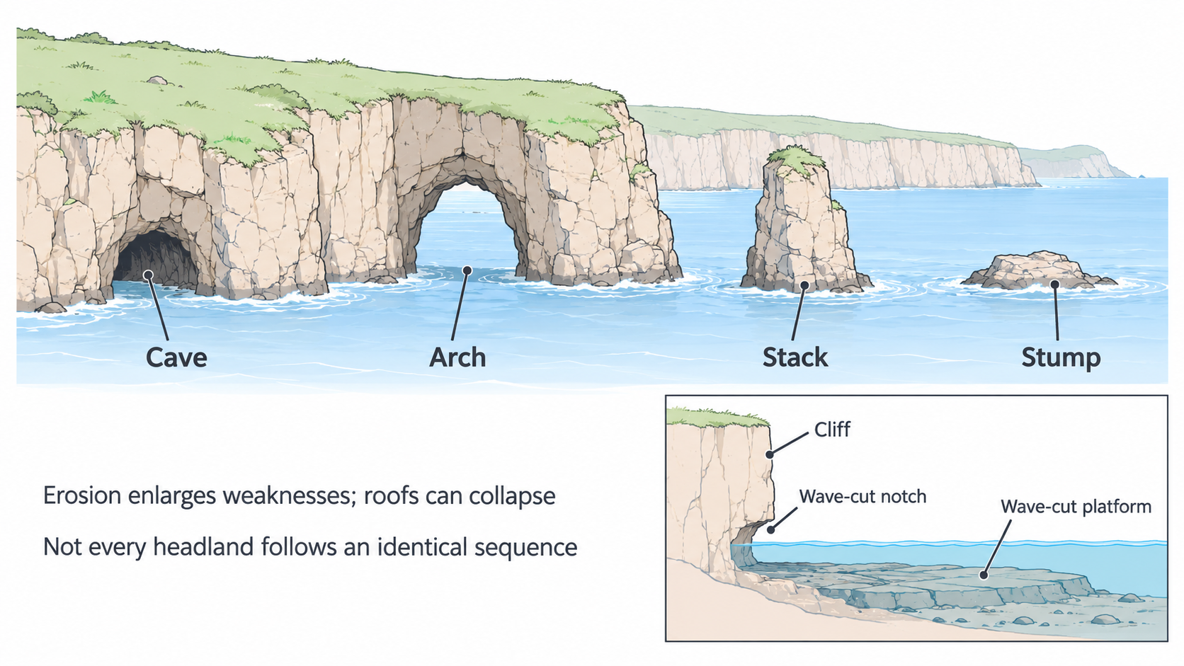
Schematic relationships, not four photographs of one headland at known dates. The platform inset shows rock remaining after cliff retreat.
Beaches and sediment balance
A beach is accumulated sand, shingle or other sediment along a shore. Material can come from eroding cliffs, rivers, offshore stores or biological sources such as shells. Waves and currents sort and redistribute it. Deposition occurs where the transporting flow loses the ability to carry some of its load.
Beaches change as inputs and losses change. Lower-energy waves can move material landward, building the beach, while storms may transfer it offshore or alongshore. Sand beaches commonly have gentler profiles than coarse shingle beaches, although local conditions vary. A wider beach often provides more space for waves to lose energy before reaching the land behind.
A coastline is part of a sediment system. To interpret a GIS map of a beach, include nearby cliffs, rivers, transport direction and coastal structures rather than mapping its width alone. Two aerial images can show change, but compare tide level, season, scale and image date before inferring a long-term loss.
Spits, bars and sheltered water
A spit is a narrow ridge of deposited sediment attached to land at one end. Longshore drift supplies material along a coast. Where the coast changes direction at a bay or estuary, sediment can continue into the water and be deposited as energy falls, extending the ridge. Wave direction changes and tidal currents can curve its tip.
Sheltered water behind a spit allows fine sediment to settle; mudflats or salt marsh may develop. A river or strong tidal currents can maintain an open estuary mouth, preventing the spit simply extending across it.
A bar can form when deposition extends a ridge across a bay and connects land at both ends. Water trapped behind it forms a lagoon. A bar therefore differs from a one-ended spit. Not every spit becomes a bar: river flow, tides, depth and sediment supply may prevent closure.
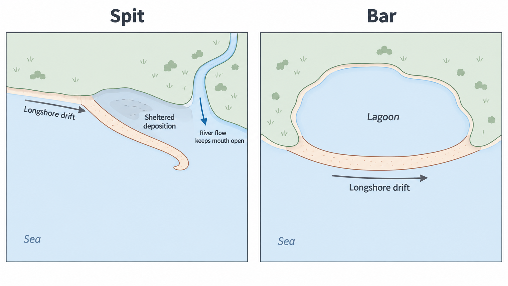
Plan-view schematic showing attachment points, sediment movement and the estuary opening.