1.2 - Upland and lowland river landforms
River landforms are the accumulated results of erosion, slope change and deposition. Follow the formation of upland valleys and waterfalls, then explain how meanders, oxbow lakes, floodplains and levees develop in lower-relief reaches.
Valleys and interlocking spurs
In a steep upper course, a river cuts down into its bed through vertical erosion. Weathering weakens rock on the valley sides, and gravity moves loosened material towards the channel. The river removes some of that material. Repeated downcutting and slope retreat help create a narrow V-shaped valley. A V-shape therefore involves both river erosion and valley-side processes; a river does not carve the entire V-shaped cross section by itself.
Small upland rivers often wind around projecting ridges of more resistant or higher ground instead of cutting a straight path through them. These alternating projections are interlocking spurs. They look as though they overlap when viewed along the valley. They are not the same as lowland meanders: the river is constrained by the existing relief rather than mainly migrating across a broad floodplain.
Upper Teesdale provides a named setting for steep valley sides, while the broader lower Tees valley shows a different balance of processes. Use contours to identify steep sides: closely spaced contours indicate steep slopes, while their arrangement shows alternating ridges and tributary valleys. A photograph alone may hide a spur behind the next ridge, so combine views with a map.
Waterfalls and retreating gorges
A waterfall can form where resistant rock overlies less resistant rock. The weaker rock is eroded more rapidly, creating a step. Falling water and its load deepen a plunge pool through hydraulic action and abrasion, while undercutting removes support from the resistant cap. An overhang develops and eventually collapses along weaknesses under its own weight. Fallen blocks may help abrade the pool, although they also have to be removed or broken down.
The new lip is farther upstream. Repeated undercutting and collapse make the waterfall retreat upstream, leaving a steep-sided gorge downstream. The water still flows downstream: retreat describes the changing position of the lip, not a reversal of river flow. Rock structure, floods and glacial history can modify this simplified sequence.
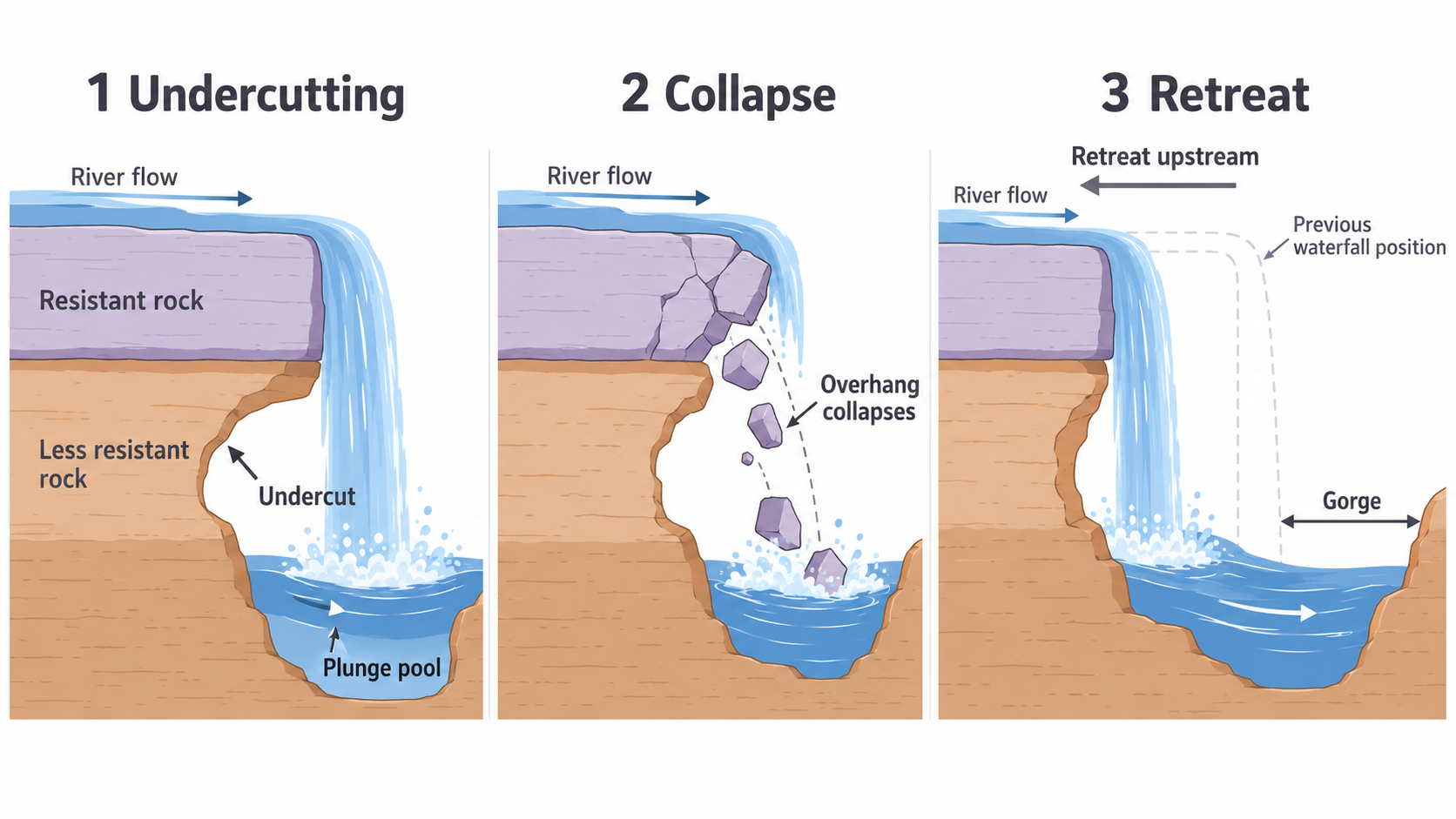
Schematic formation sequence. The left-pointing retreat arrow describes the lip's movement; water flows to the right.
At High Force on the River Tees, resistant Whin Sill dolerite overlies sedimentary rocks, including sandstone and limestone. Their different resistance helps explain the waterfall. The North Pennines landscape authority also identifies the role of meltwater during the last ice age in shaping the gorge, so present-day flow is not its only historical influence.
Meanders and channel migration
A meander is a bend in a river. In many bends, the fastest current is directed towards the outer bank. Greater erosion creates a steep river cliff and a deeper channel there. Water is slower in the shallower inner bend, where sediment is deposited as a slip-off slope or point bar. The bend changes position as erosion removes one bank and deposition builds the other.
The pattern is more complex than water simply travelling in two separate lanes. Flow spirals through bends, helping transfer sediment from the outer-bank area towards the inner bar. Vegetation, bank strength and floods affect migration. Opposite banks can therefore record erosion and deposition at the same time without contradiction.
Meanders in the lower Tees near Yarm can be located on a map or aerial image. Trace the curved channel, identify its outer and inner sides, then compare with available bank or sediment evidence. A curved blue map line proves a bend exists; it does not alone prove which bank is currently eroding fastest.
Oxbow lakes and cutoffs
As neighbouring bends enlarge, erosion on their outer banks can narrow the land between them, called the neck. During high discharge, water may cut across the neck along a shorter, steeper route. That route attracts more flow and is enlarged by erosion. The former loop receives less flow, which encourages deposition near its entrances. It can become separated as an oxbow lake.
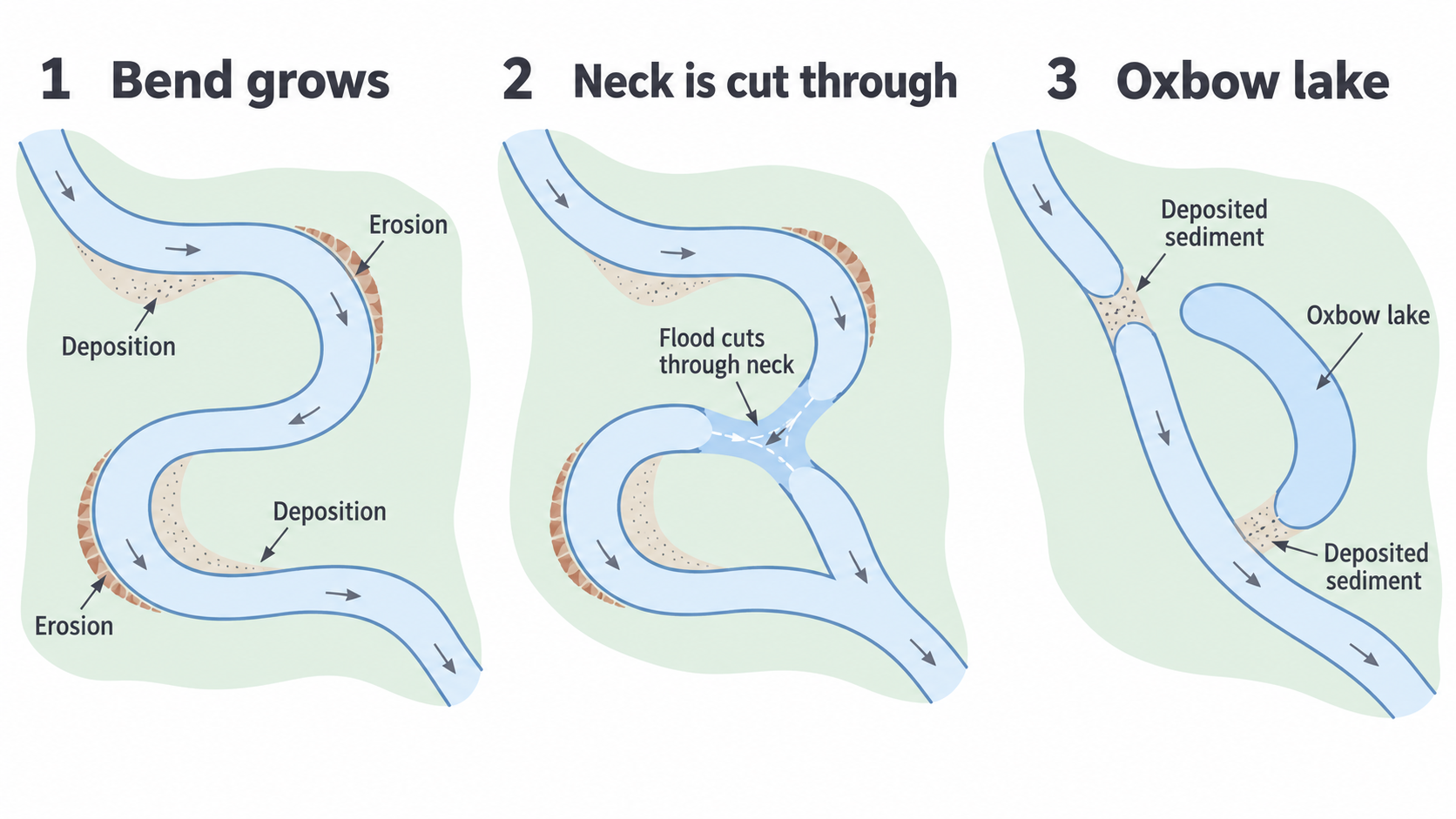
A schematic cutoff sequence. Deposition seals the former loop after the main river adopts the shorter channel.
A cutoff can happen rapidly during a flood even though the bend took years to develop. The lake may later fill with fine sediment and vegetation, leaving a meander scar. Not every bend becomes an oxbow; bank resistance, flood paths and human engineering influence the outcome.
Floodplains and natural levees
A floodplain is relatively flat land alongside a river that can be inundated when water exceeds channel capacity. Meander migration and lateral erosion help widen the valley floor. During floods, water spreads out, becomes shallower and encounters more friction, so it loses transporting ability. Alluvium, river-deposited sediment, accumulates across the flooded land. Repeated floods build up deposits over time.
Water slows sharply on leaving the channel. Coarser sediment is often deposited first near the banks; finer particles can be carried farther across the floodplain. Repeated deposition can build raised banks called natural levees. They are depositional landforms, unlike artificial flood embankments built by people. Natural levees can reduce the frequency of smaller overbank flows but are not a guarantee against a large flood or a breach.
A floodplain is not created by deposition alone: lateral erosion and channel movement help produce its width and shape. On a lower-course map, look for a wide flat valley floor and meander traces; combine that with sediment or height evidence rather than treating every flat surface as a floodplain.
Explain a landform as a sequence: the changing conditions, the processes they cause, and the resulting shape. A landform name by itself does not explain its formation.