2.1 - Coastal processes and their controls
Coasts change through wave action, weathering, gravity and sediment movement. Learn how these processes work together and why geology, vegetation, people and sea-level change make neighbouring stretches respond differently.
Wave action and energy
Wind transfers energy to the sea surface. Wave size depends on wind strength, how long it blows and the distance over water it blows across, called fetch. Waves mainly transfer energy: water particles move in orbital paths rather than travelling across an ocean with every wave. As waves enter shallow water, interaction with the seabed slows and steepens them until they break.
Swash is water moving up a beach after a wave breaks; backwash returns downslope under gravity. Lower, less frequent waves with relatively strong swash can add beach material and are often called constructive. Steeper, more frequent waves with powerful backwash can remove material and are often called destructive. These describe tendencies, not two permanent kinds of coastline. The same beach can gain sediment in one season and lose it in a storm.
A wide beach can absorb wave energy before it reaches a cliff or sea wall. Removing beach sediment can expose the land behind to stronger attack, connecting sediment transport to erosion risk.
Erosion and sediment transport
Hydraulic action occurs when waves exert force on rock and compress air or water in cracks. Abrasion occurs when transported sediment strikes and scrapes the coast. Attrition makes colliding sediment particles smaller and rounder; solution removes soluble minerals. Jointed or weak rock often offers more opportunities for removal than massive resistant rock.
Waves and currents transport sediment. Coarse material can roll or slide (traction), smaller grains bounce (saltation), fine particles travel in suspension, and dissolved substances move in solution. Deposition occurs when the flow can no longer carry some of its load, often in sheltered or lower-energy water.
Longshore drift moves beach sediment along a coast. When waves approach obliquely, swash carries grains up the beach at an angle. Backwash returns more directly downslope, approximately perpendicular to the shoreline. Repetition produces a zigzag path and net transport alongshore. A change in wave direction can reverse transport; the long-term net direction need not match every individual day.
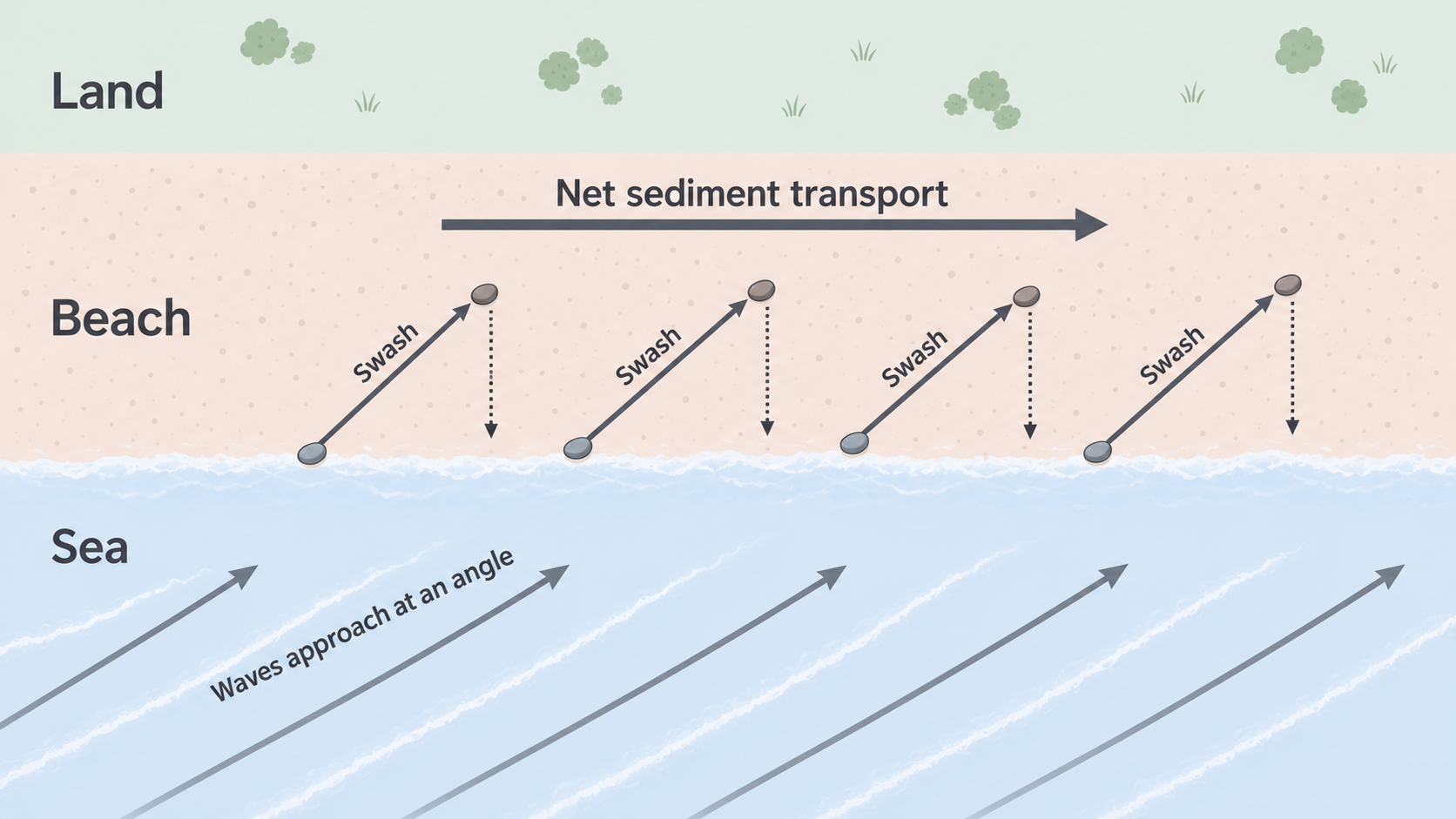
Plan-view schematic: the repeated swash and backwash steps produce net movement to the right. The separate arrow pairs illustrate the mechanism rather than measured pebble positions.
Weathering, sliding and slumping
Weathering breaks down rock in place. Mechanical weathering includes freeze-thaw action where conditions allow and salt-crystal growth in pores. Chemical weathering includes reactions such as dissolution of limestone by weakly acidic water. Biological weathering includes roots widening cracks and organisms producing acids. These processes can weaken a cliff before waves remove material.
Mass movement transfers material downslope under gravity. A slide moves along a relatively planar surface. A slump rotates along a curved failure surface, commonly in weak or waterlogged material. Water can increase weight and pore pressure, reducing effective friction or strength. Waves may also remove support at the foot, making failure more likely.
Consider a clay-rich cliff after prolonged rain and storm waves. Saturation weakens the material while marine erosion undercuts its base. A rotational slump can occur even after the largest waves have passed. Calling the whole event “wave erosion” misses gravity and water within the cliff.
Geology and vegetation controls
Rock type affects resistance, permeability and weathering. Structure affects the position and direction of joints, faults and bedding planes. Two cliffs made of the same rock can erode differently if one is more fractured. Alternating resistant and less resistant beds can produce contrasting coastal shapes.
A geological map can be compared with a coastline map. Mark the rock contacts and ask whether bays coincide with less resistant material or headlands with more resistant rock. Then test alternatives: wave exposure, coastal structures and differences in jointing may also influence the pattern. A correlation is evidence for a mechanism, not proof that geology acts alone.
Apply this using the BGS Geology Viewer around Flamborough Head and Holderness. Read both the bedrock and superficial-deposit legends: exposed chalk and a coast dominated by unconsolidated glacial deposits provide different resistance and stability conditions. Overlay the coastline, settlements and defences in GIS to investigate why retreat varies. Turning a layer off can reveal features hidden by another, but matching coloured areas to coastal form still requires a process explanation.
Vegetation can bind dune or cliff-top soil with roots and intercept rainfall. It can also contribute to biological weathering. Removing vegetation may expose loose sediment to wind and runoff. The effect depends on root depth, substrate and wave attack: grass does not prevent the sea eroding an unprotected cliff base indefinitely.
People and changing sea level
People alter sediment supply and wave attack. Groynes can retain sand locally but reduce supply farther alongshore. Dredging, sand extraction or river dams can change the sediment reaching a coastal system. Ports, buildings and sea walls change the shape or mobility of the shoreline, while trampling can damage stabilising dune plants.
Relative sea level is sea height compared with the land. It can rise because the ocean rises or the land sinks, and fall where land uplift outpaces ocean rise. Rising relative sea level allows waves to act higher on the coast and can increase flood exposure. A storm surge is a temporary weather-driven rise; it is distinct from the longer-term change, although they can combine.
A coastal change usually has several causes. Explain the interaction between wave energy, sediment supply, rock or slope properties and human intervention before deciding which factor matters most.